![](/images/other/stat-length.png)
![Excursión Senderismo Merksplas - Met de Nederlandse grens spelen in Merksplas - Photo](https://media.geolcdn.com/t/1900/400/ext.pjpeg?maxdim=2&url=https%3A%2F%2Fstatic1.geolcdn.com%2Fsiteimages%2Fupload%2Ffiles%2F1553511878bg_sport_marche.png)
Met de Nederlandse grens spelen in Merksplas
LucThomaere
Usuario
![Longitud](/images/other/stat-length.png)
Longitud
18,8 km
![Altitud máxima](https://static1.geolcdn.com/siteimages/upload/files/1508320355ic_sort_altitude_max_24dp.png)
Altitud máxima
36 m
![Desnivel positivo](https://static1.geolcdn.com/siteimages/upload/files/1508320355ic_sort_den_pos_24dp.png)
Desnivel positivo
100 m
![Km-Effort](/images/other/stat-length.png)
Km-Effort
20 km
![Altitud mínima](https://static1.geolcdn.com/siteimages/upload/files/1508320355ic_sort_altitude_min_24dp.png)
Altitud mínima
16 m
![Desnivel negativo](https://static1.geolcdn.com/siteimages/upload/files/1508320355ic_sort_den_neg_24dp.png)
Desnivel negativo
100 m
![Boucle](https://static1.geolcdn.com/siteimages/upload/files/16400158638029165_repeat_loop_refresh_sync_direction_icon.png)
Boucle
Sí
Fecha de creación :
2021-09-26 10:58:47.0
Última modificación :
2021-09-27 07:19:53.895
![Senderismo](https://static1.geolcdn.com/sitytour/trail-icons/101.png)
4h55
Dificultad : Medio
![Escanee este código QR para abrir la excursión en la aplicación SityTrail](https://capi.geolives.com/qq0zvz2zws4bq2lad0pu/sitytour/trails/2950521/qr.png?size=200)
Aplicación GPS de excursión GRATIS
A propósito
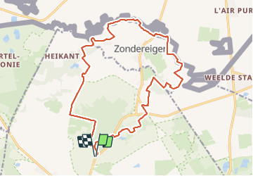
Ruta Senderismo de 18,8 km a descubrir en Flandes, Amberes, Merksplas. Esta ruta ha sido propuesta por LucThomaere.
Descripción
Weinig bebouwing, vele panorama's, de grensstreek op haar mooist.
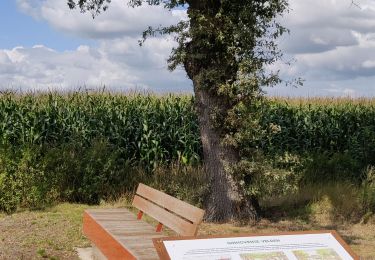
Voor wie van panorama's houdt: vermijdt de periode dat de maïs op haar hoogst staat (september)
Localización
País:
Belgium
Región :
Flandes
Departamento/provincia :
Amberes
Municipio :
Merksplas
Localidad:
Unknown
Salida:(Dec)
Salida:(UTM)
630183 ; 5693021 (31U) N.
Comentarios
Excursiones cerca
![Excursión Senderismo Merksplas - Vossenbergwandeling - Photo](https://media.geolcdn.com/t/375/260/b1242961-7b45-4aa1-80bb-578d573a1248.jpg&format=jpg&maxdim=2)
![Senderismo Senderismo](https://static1.geolcdn.com/sitytour/trail-icons/101.png)
Vossenbergwandeling
Senderismo
Muy fácil
Merksplas,
Flandes,
Amberes,
Belgium
![](/images/other/stat-length.png)
8,3 km | 8,8 km-effort
1h 49min
![](https://static1.geolcdn.com/siteimages/upload/files/16400158638029165_repeat_loop_refresh_sync_direction_icon.png)
No
![Excursión Senderismo Beerse - Blackheide - Photo](https://media.geolcdn.com/t/375/260/8457e976-ce2c-4f86-89e9-a2e5b61d602a.jpg&format=jpg&maxdim=2)
![Senderismo Senderismo](https://static1.geolcdn.com/sitytour/trail-icons/101.png)
![Excursión Bicicleta Turnhout - f-belgie-van-noord-naar-zuud-in-belgie - Photo](https://media.geolcdn.com/t/375/260/ext.jpg?maxdim=2&url=https%3A%2F%2Fstatic1.geolcdn.com%2Fsiteimages%2Fupload%2Ffiles%2F1524743154velo.jpg)
![Bicicleta Bicicleta](https://static1.geolcdn.com/sitytour/trail-icons/200.png)
f-belgie-van-noord-naar-zuud-in-belgie
Bicicleta
Muy fácil
Turnhout,
Flandes,
Amberes,
Belgium
![](/images/other/stat-length.png)
358 km | 424 km-effort
Desconocido
![](https://static1.geolcdn.com/siteimages/upload/files/16400158638029165_repeat_loop_refresh_sync_direction_icon.png)
No
![Excursión Senderismo Rijkevorsel - Belgie - GR Kempen 2 - Photo](https://media.geolcdn.com/t/375/260/ext.jpg?maxdim=2&url=https%3A%2F%2Fstatic1.geolcdn.com%2Fsiteimages%2Fupload%2Ffiles%2F1553511878bg_sport_marche.png)
![Senderismo Senderismo](https://static1.geolcdn.com/sitytour/trail-icons/101.png)
Belgie - GR Kempen 2
Senderismo
Muy fácil
Rijkevorsel,
Flandes,
Amberes,
Belgium
![](/images/other/stat-length.png)
23 km | 24 km-effort
Desconocido
![](https://static1.geolcdn.com/siteimages/upload/files/16400158638029165_repeat_loop_refresh_sync_direction_icon.png)
No
![Excursión Senderismo Beerse - Belgie - Boswandeling Beerse - Photo](https://media.geolcdn.com/t/375/260/ext.jpg?maxdim=2&url=https%3A%2F%2Fstatic1.geolcdn.com%2Fsiteimages%2Fupload%2Ffiles%2F1553511878bg_sport_marche.png)
![Senderismo Senderismo](https://static1.geolcdn.com/sitytour/trail-icons/101.png)
Belgie - Boswandeling Beerse
Senderismo
Muy fácil
Beerse,
Flandes,
Amberes,
Belgium
![](/images/other/stat-length.png)
3,6 km | 4 km-effort
Desconocido
![](https://static1.geolcdn.com/siteimages/upload/files/16400158638029165_repeat_loop_refresh_sync_direction_icon.png)
Sí
![Excursión Senderismo Ravels - Weelde WeeldeStation Ravels - 10 km RT - Photo](https://media.geolcdn.com/t/375/260/ext.jpg?maxdim=2&url=https%3A%2F%2Fstatic1.geolcdn.com%2Fsiteimages%2Fupload%2Ffiles%2F1553511878bg_sport_marche.png)
![Senderismo Senderismo](https://static1.geolcdn.com/sitytour/trail-icons/101.png)
Weelde WeeldeStation Ravels - 10 km RT
Senderismo
Muy fácil
Ravels,
Flandes,
Amberes,
Belgium
![](/images/other/stat-length.png)
9,3 km | 9,9 km-effort
Desconocido
![](https://static1.geolcdn.com/siteimages/upload/files/16400158638029165_repeat_loop_refresh_sync_direction_icon.png)
Sí
![Excursión Senderismo Ravels - Weelde Station naar Zwarte Heide - 13 km RT - Photo](https://media.geolcdn.com/t/375/260/ext.jpg?maxdim=2&url=https%3A%2F%2Fstatic1.geolcdn.com%2Fsiteimages%2Fupload%2Ffiles%2F1553511878bg_sport_marche.png)
![Senderismo Senderismo](https://static1.geolcdn.com/sitytour/trail-icons/101.png)
Weelde Station naar Zwarte Heide - 13 km RT
Senderismo
Muy fácil
Ravels,
Flandes,
Amberes,
Belgium
![](/images/other/stat-length.png)
13 km | 13,9 km-effort
Desconocido
![](https://static1.geolcdn.com/siteimages/upload/files/16400158638029165_repeat_loop_refresh_sync_direction_icon.png)
Sí
![Excursión Senderismo Turnhout - Turnhout Zwart Water Pad - 7 km RT - Photo](https://media.geolcdn.com/t/375/260/ext.jpg?maxdim=2&url=https%3A%2F%2Fstatic1.geolcdn.com%2Fsiteimages%2Fupload%2Ffiles%2F1553511878bg_sport_marche.png)
![Senderismo Senderismo](https://static1.geolcdn.com/sitytour/trail-icons/101.png)
Turnhout Zwart Water Pad - 7 km RT
Senderismo
Muy fácil
Turnhout,
Flandes,
Amberes,
Belgium
![](/images/other/stat-length.png)
6,9 km | 7,2 km-effort
Desconocido
![](https://static1.geolcdn.com/siteimages/upload/files/16400158638029165_repeat_loop_refresh_sync_direction_icon.png)
Sí
![Excursión Senderismo Turnhout - Turnhout Turnhouts vennengebied - 9 km RT - Photo](https://media.geolcdn.com/t/375/260/ext.jpg?maxdim=2&url=https%3A%2F%2Fstatic1.geolcdn.com%2Fsiteimages%2Fupload%2Ffiles%2F1553511878bg_sport_marche.png)
![Senderismo Senderismo](https://static1.geolcdn.com/sitytour/trail-icons/101.png)
Turnhout Turnhouts vennengebied - 9 km RT
Senderismo
Muy fácil
Turnhout,
Flandes,
Amberes,
Belgium
![](/images/other/stat-length.png)
9 km | 9,8 km-effort
Desconocido
![](https://static1.geolcdn.com/siteimages/upload/files/16400158638029165_repeat_loop_refresh_sync_direction_icon.png)
Sí