![](/images/other/stat-length.png)
![Excursión Senderismo Bazoches - Compestelle etape 2 - Photo](https://media.geolcdn.com/t/1900/400/ext.pjpeg?maxdim=2&url=https%3A%2F%2Fstatic1.geolcdn.com%2Fsiteimages%2Fupload%2Ffiles%2F1553511878bg_sport_marche.png)
Compestelle etape 2
maginot
Usuario
![Longitud](/images/other/stat-length.png)
Longitud
22 km
![Altitud máxima](https://static1.geolcdn.com/siteimages/upload/files/1508320355ic_sort_altitude_max_24dp.png)
Altitud máxima
326 m
![Desnivel positivo](https://static1.geolcdn.com/siteimages/upload/files/1508320355ic_sort_den_pos_24dp.png)
Desnivel positivo
436 m
![Km-Effort](/images/other/stat-length.png)
Km-Effort
28 km
![Altitud mínima](https://static1.geolcdn.com/siteimages/upload/files/1508320355ic_sort_altitude_min_24dp.png)
Altitud mínima
188 m
![Desnivel negativo](https://static1.geolcdn.com/siteimages/upload/files/1508320355ic_sort_den_neg_24dp.png)
Desnivel negativo
541 m
![Boucle](https://static1.geolcdn.com/siteimages/upload/files/16400158638029165_repeat_loop_refresh_sync_direction_icon.png)
Boucle
No
Fecha de creación :
2021-09-21 07:08:59.0
Última modificación :
2021-09-21 15:43:21.062
![Senderismo](https://static1.geolcdn.com/sitytour/trail-icons/101.png)
6h06
Dificultad : Medio
![Escanee este código QR para abrir la excursión en la aplicación SityTrail](https://capi.geolives.com/qq0zvz2zws4bq2lad0pu/sitytour/trails/2944645/qr.png?size=200)
Aplicación GPS de excursión GRATIS
A propósito
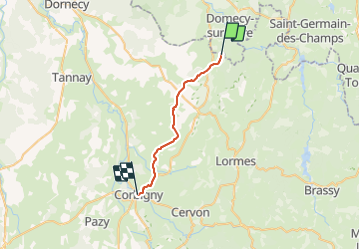
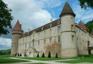
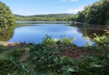
Ruta Senderismo de 22 km a descubrir en Borgoña-Franco Condado, Nièvre, Bazoches. Esta ruta ha sido propuesta por maginot.
Descripción
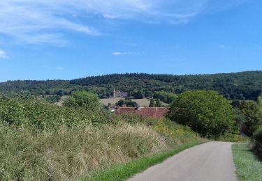
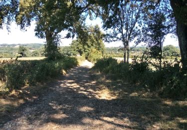
Départ de Domecy sur Cure 8h brouillard et pluie,parcours au début sympa jusqu’à Bazoches puis après beaucoup de route surtout à la fin
Arrêt à Corbigny au refuge mairie
Très bien en plus je suis seul
Localización
País:
France
Región :
Borgoña-Franco Condado
Departamento/provincia :
Nièvre
Municipio :
Bazoches
Localidad:
Unknown
Salida:(Dec)
Salida:(UTM)
560289 ; 5248595 (31T) N.
Comentarios
Excursiones cerca
![Excursión Senderismo Saint-André-en-Morvan - SAINT-ANDRE-EN-MORVAN (9/20) - Photo](https://media.geolcdn.com/t/375/260/ext.jpg?maxdim=2&url=https%3A%2F%2Fmedia.geolcdn.com%2Ff%2F2afd1577-a731-4de7-8e6f-0fb7b3dcf911.jpg)
![Senderismo Senderismo](https://static1.geolcdn.com/sitytour/trail-icons/101.png)
SAINT-ANDRE-EN-MORVAN (9/20)
Senderismo
Medio
Saint-André-en-Morvan,
Borgoña-Franco Condado,
Nièvre,
France
![](/images/other/stat-length.png)
8,9 km | 11,8 km-effort
3h 15min
![](https://static1.geolcdn.com/siteimages/upload/files/16400158638029165_repeat_loop_refresh_sync_direction_icon.png)
Sí
![Excursión Senderismo Bazoches - BAZOCHES - (9/20) - Photo](https://media.geolcdn.com/t/375/260/ext.jpg?maxdim=2&url=https%3A%2F%2Fmedia.geolcdn.com%2Ff%2F311c8b98-292f-4397-a886-c9a8ef5e96fd.jpg)
![Senderismo Senderismo](https://static1.geolcdn.com/sitytour/trail-icons/101.png)
BAZOCHES - (9/20)
Senderismo
Medio
Bazoches,
Borgoña-Franco Condado,
Nièvre,
France
![](/images/other/stat-length.png)
10,7 km | 15 km-effort
3h 43min
![](https://static1.geolcdn.com/siteimages/upload/files/16400158638029165_repeat_loop_refresh_sync_direction_icon.png)
Sí
![Excursión Senderismo Pierre-Perthuis - Pierre-Perthuis-Vezelay - Photo](https://media.geolcdn.com/t/375/260/ext.jpg?maxdim=2&url=https%3A%2F%2Fservices.sitytrail.com%2FGeolivesWS%2FDownloadMedia.ashx%3FTrailID%3D1030999%26Media%3Dfix__20180826153418.jpg)
![Senderismo Senderismo](https://static1.geolcdn.com/sitytour/trail-icons/101.png)
Pierre-Perthuis-Vezelay
Senderismo
Difícil
Pierre-Perthuis,
Borgoña-Franco Condado,
Yonne,
France
![](/images/other/stat-length.png)
16,8 km | 22 km-effort
4h 24min
![](https://static1.geolcdn.com/siteimages/upload/files/16400158638029165_repeat_loop_refresh_sync_direction_icon.png)
Sí
![Excursión Senderismo Bazoches - Autour de Vauban - Bazoches - Photo](https://media.geolcdn.com/t/375/260/ext.jpg?maxdim=2&url=https%3A%2F%2Fservices.sitytrail.com%2FGeolivesWS%2FDownloadMedia.ashx%3FTrailID%3D105713%26Media%3D9558_2.jpg)
![Senderismo Senderismo](https://static1.geolcdn.com/sitytour/trail-icons/101.png)
Autour de Vauban - Bazoches
Senderismo
Medio
(1)
Bazoches,
Borgoña-Franco Condado,
Nièvre,
France
![](/images/other/stat-length.png)
11,1 km | 15,5 km-effort
3h 10min
![](https://static1.geolcdn.com/siteimages/upload/files/16400158638029165_repeat_loop_refresh_sync_direction_icon.png)
Sí
![Excursión Caballo Bazoches - SityTrail - chateau de Vauban - Photo](https://media.geolcdn.com/t/375/260/ext.jpg?maxdim=2&url=https%3A%2F%2Fstatic1.geolcdn.com%2Fsiteimages%2Fupload%2Ffiles%2F1524743154cheval.jpg)
![Caballo Caballo](https://static1.geolcdn.com/sitytour/trail-icons/300.png)
SityTrail - chateau de Vauban
Caballo
Muy fácil
Bazoches,
Borgoña-Franco Condado,
Nièvre,
France
![](/images/other/stat-length.png)
12,7 km | 17,5 km-effort
Desconocido
![](https://static1.geolcdn.com/siteimages/upload/files/16400158638029165_repeat_loop_refresh_sync_direction_icon.png)
Sí
![Excursión Bici de carretera Bazoches - champign-brassy-chalaux - Photo](https://media.geolcdn.com/t/375/260/ext.jpg?maxdim=2&url=https%3A%2F%2Fmedia.geolcdn.com%2Ff%2F2bcbfe87-c01d-4d50-a383-6ca3bbe4fa3c.jpg)
![Bici de carretera Bici de carretera](https://static1.geolcdn.com/sitytour/trail-icons/201.png)
champign-brassy-chalaux
Bici de carretera
Difícil
Bazoches,
Borgoña-Franco Condado,
Nièvre,
France
![](/images/other/stat-length.png)
50 km | 64 km-effort
2h 53min
![](https://static1.geolcdn.com/siteimages/upload/files/16400158638029165_repeat_loop_refresh_sync_direction_icon.png)
Sí
![Excursión A pie Saint-André-en-Morvan - Morvan jour 4: Saint-André en Morvan à le Vieux Dun - Photo](https://media.geolcdn.com/t/375/260/ext.jpg?maxdim=2&url=https%3A%2F%2Fstatic1.geolcdn.com%2Fsiteimages%2Fupload%2Ffiles%2F1545311037marcheuse_200dpi.jpg)
![A pie A pie](https://static1.geolcdn.com/sitytour/trail-icons/100.png)
Morvan jour 4: Saint-André en Morvan à le Vieux Dun
A pie
Difícil
Saint-André-en-Morvan,
Borgoña-Franco Condado,
Nièvre,
France
![](/images/other/stat-length.png)
22 km | 32 km-effort
7h 11min
![](https://static1.geolcdn.com/siteimages/upload/files/16400158638029165_repeat_loop_refresh_sync_direction_icon.png)
No
![Excursión Paseo ecuestre Bazoches - chateau de Vauban - Photo](https://media.geolcdn.com/t/375/260/ext.jpg?maxdim=2&url=https%3A%2F%2Fstatic1.geolcdn.com%2Fsiteimages%2Fupload%2Ffiles%2F1524743154cheval.jpg)
![Paseo ecuestre Paseo ecuestre](https://static1.geolcdn.com/sitytour/trail-icons/301.png)
chateau de Vauban
Paseo ecuestre
Fácil
Bazoches,
Borgoña-Franco Condado,
Nièvre,
France
![](/images/other/stat-length.png)
12,7 km | 17,6 km-effort
1h 42min
![](https://static1.geolcdn.com/siteimages/upload/files/16400158638029165_repeat_loop_refresh_sync_direction_icon.png)
Sí
![Excursión Senderismo Saint-André-en-Morvan - Saint André en Morvan - Photo](https://media.geolcdn.com/t/375/260/ext.jpg?maxdim=2&url=https%3A%2F%2Fstatic1.geolcdn.com%2Fsiteimages%2Fupload%2Ffiles%2F1553511878bg_sport_marche.png)
![Senderismo Senderismo](https://static1.geolcdn.com/sitytour/trail-icons/101.png)
Saint André en Morvan
Senderismo
Difícil
Saint-André-en-Morvan,
Borgoña-Franco Condado,
Nièvre,
France
![](/images/other/stat-length.png)
10,9 km | 14,9 km-effort
3h 0min
![](https://static1.geolcdn.com/siteimages/upload/files/16400158638029165_repeat_loop_refresh_sync_direction_icon.png)
Sí