![](/images/other/stat-length.png)
![Excursión Senderismo Saint-Laurent-sur-Sèvre - Saint Laurent sur Sèvre viaduc de Barbin Le Guy 15km - Photo](https://media.geolcdn.com/t/1900/400/ext.pjpeg?maxdim=2&url=https%3A%2F%2Fstatic1.geolcdn.com%2Fsiteimages%2Fupload%2Ffiles%2F1553511878bg_sport_marche.png)
Saint Laurent sur Sèvre viaduc de Barbin Le Guy 15km
marianne guichoux
Usuario
![Longitud](/images/other/stat-length.png)
Longitud
14,8 km
![Altitud máxima](https://static1.geolcdn.com/siteimages/upload/files/1508320355ic_sort_altitude_max_24dp.png)
Altitud máxima
161 m
![Desnivel positivo](https://static1.geolcdn.com/siteimages/upload/files/1508320355ic_sort_den_pos_24dp.png)
Desnivel positivo
253 m
![Km-Effort](/images/other/stat-length.png)
Km-Effort
18,2 km
![Altitud mínima](https://static1.geolcdn.com/siteimages/upload/files/1508320355ic_sort_altitude_min_24dp.png)
Altitud mínima
97 m
![Desnivel negativo](https://static1.geolcdn.com/siteimages/upload/files/1508320355ic_sort_den_neg_24dp.png)
Desnivel negativo
253 m
![Boucle](https://static1.geolcdn.com/siteimages/upload/files/16400158638029165_repeat_loop_refresh_sync_direction_icon.png)
Boucle
Sí
Fecha de creación :
2021-09-13 18:00:04.408
Última modificación :
2021-09-13 18:07:18.37
![Senderismo](https://static1.geolcdn.com/sitytour/trail-icons/101.png)
4h08
Dificultad : Difícil
![Escanee este código QR para abrir la excursión en la aplicación SityTrail](https://capi.geolives.com/qq0zvz2zws4bq2lad0pu/sitytour/trails/2935675/qr.png?size=200)
Aplicación GPS de excursión GRATIS
A propósito
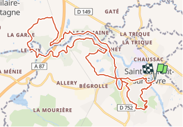
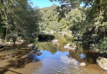
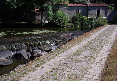
Ruta Senderismo de 14,8 km a descubrir en Países del Loira, Vandea, Saint-Laurent-sur-Sèvre. Esta ruta ha sido propuesta por marianne guichoux.
Descripción
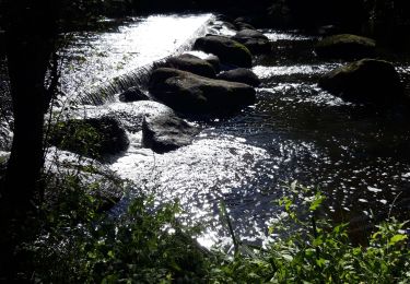
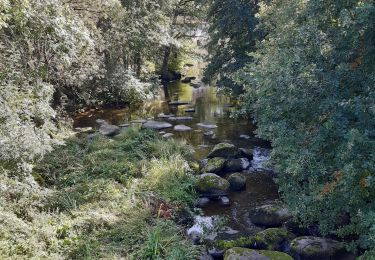
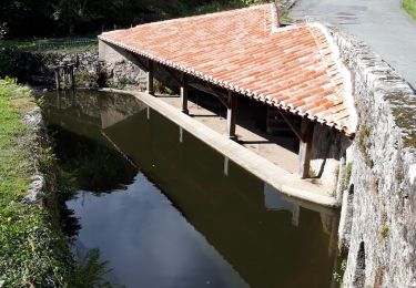
parcours visite de Saint Laurent, la croix Brébion,la Tourette,la porte des martyrs,moulin de l'étourneau viaduc de Barbin,la chaussée du guy
Localización
País:
France
Región :
Países del Loira
Departamento/provincia :
Vandea
Municipio :
Saint-Laurent-sur-Sèvre
Localidad:
Unknown
Salida:(Dec)
Salida:(UTM)
660773 ; 5202757 (30T) N.
Comentarios
Excursiones cerca
![Excursión Senderismo Cholet - Le Puy St Bonnet - St Laurent Sur Sèvre Les Balcons - Photo](https://media.geolcdn.com/t/375/260/ext.jpg?maxdim=2&url=https%3A%2F%2Fstatic1.geolcdn.com%2Fsiteimages%2Fupload%2Ffiles%2F1553511878bg_sport_marche.png)
![Senderismo Senderismo](https://static1.geolcdn.com/sitytour/trail-icons/101.png)
Le Puy St Bonnet - St Laurent Sur Sèvre Les Balcons
Senderismo
Fácil
(2)
Cholet,
Países del Loira,
Maine-y-Loira,
France
![](/images/other/stat-length.png)
23 km | 28 km-effort
4h 39min
![](https://static1.geolcdn.com/siteimages/upload/files/16400158638029165_repeat_loop_refresh_sync_direction_icon.png)
Sí
![Excursión Senderismo Saint-Laurent-sur-Sèvre - Rando St Laurent sur Sèvres 15km - Photo](https://media.geolcdn.com/t/375/260/c7b25b6b-16fe-4f42-959a-3db8fae12baf.jpg&format=jpg&maxdim=2)
![Senderismo Senderismo](https://static1.geolcdn.com/sitytour/trail-icons/101.png)
Rando St Laurent sur Sèvres 15km
Senderismo
Muy difícil
Saint-Laurent-sur-Sèvre,
Países del Loira,
Vandea,
France
![](/images/other/stat-length.png)
15,4 km | 19,1 km-effort
4h 14min
![](https://static1.geolcdn.com/siteimages/upload/files/16400158638029165_repeat_loop_refresh_sync_direction_icon.png)
Sí
![Excursión Senderismo Saint-Laurent-sur-Sèvre - ViaducBarbin - Photo](https://media.geolcdn.com/t/375/260/ext.jpg?maxdim=2&url=https%3A%2F%2Fstatic1.geolcdn.com%2Fsiteimages%2Fupload%2Ffiles%2F1553511878bg_sport_marche.png)
![Senderismo Senderismo](https://static1.geolcdn.com/sitytour/trail-icons/101.png)
ViaducBarbin
Senderismo
Fácil
(2)
Saint-Laurent-sur-Sèvre,
Países del Loira,
Vandea,
France
![](/images/other/stat-length.png)
8,4 km | 10,4 km-effort
2h 17min
![](https://static1.geolcdn.com/siteimages/upload/files/16400158638029165_repeat_loop_refresh_sync_direction_icon.png)
Sí
![Excursión Senderismo Mortagne-sur-Sèvre - Mortagbe sur Sèvre 15 km - Photo](https://media.geolcdn.com/t/375/260/a5f619e0-d31b-4e77-a119-9a1f352b2b4b.jpg&format=jpg&maxdim=2)
![Senderismo Senderismo](https://static1.geolcdn.com/sitytour/trail-icons/101.png)
Mortagbe sur Sèvre 15 km
Senderismo
Difícil
Mortagne-sur-Sèvre,
Países del Loira,
Vandea,
France
![](/images/other/stat-length.png)
15 km | 18 km-effort
4h 1min
![](https://static1.geolcdn.com/siteimages/upload/files/16400158638029165_repeat_loop_refresh_sync_direction_icon.png)
Sí
![Excursión Senderismo Treize-Vents - rando les treize cents 18km - Photo](https://media.geolcdn.com/t/375/260/7348d043-cdab-4698-91ff-220ba9aac84e.jpg&format=jpg&maxdim=2)
![Senderismo Senderismo](https://static1.geolcdn.com/sitytour/trail-icons/101.png)
rando les treize cents 18km
Senderismo
Muy difícil
Treize-Vents,
Países del Loira,
Vandea,
France
![](/images/other/stat-length.png)
19,6 km | 24 km-effort
4h 47min
![](https://static1.geolcdn.com/siteimages/upload/files/16400158638029165_repeat_loop_refresh_sync_direction_icon.png)
No
![Excursión Senderismo Treize-Vents - treize vents Mallievre - Photo](https://media.geolcdn.com/t/375/260/51e2291d-e12b-49f3-948f-44d737b92c39.jpg&format=jpg&maxdim=2)
![Senderismo Senderismo](https://static1.geolcdn.com/sitytour/trail-icons/101.png)
treize vents Mallievre
Senderismo
Muy difícil
Treize-Vents,
Países del Loira,
Vandea,
France
![](/images/other/stat-length.png)
18,1 km | 23 km-effort
4h 51min
![](https://static1.geolcdn.com/siteimages/upload/files/16400158638029165_repeat_loop_refresh_sync_direction_icon.png)
No
![Excursión Senderismo Saint-Laurent-sur-Sèvre - saint laurent sur sevre - Photo](https://media.geolcdn.com/t/375/260/d247702a-eb5a-429d-9027-07e5d3f199a5.jpg&format=jpg&maxdim=2)
![Senderismo Senderismo](https://static1.geolcdn.com/sitytour/trail-icons/101.png)
saint laurent sur sevre
Senderismo
Difícil
Saint-Laurent-sur-Sèvre,
Países del Loira,
Vandea,
France
![](/images/other/stat-length.png)
14 km | 17,4 km-effort
3h 52min
![](https://static1.geolcdn.com/siteimages/upload/files/16400158638029165_repeat_loop_refresh_sync_direction_icon.png)
No
![Excursión Bici de montaña Mortagne-sur-Sèvre - La Mortagnaise 2009 - Photo](https://media.geolcdn.com/t/375/260/ext.jpg?maxdim=2&url=https%3A%2F%2Fservices.sitytrail.com%2FGeolivesWS%2FDownloadMedia.ashx%3FTrailID%3D104021%26Media%3D6982_1.jpg)
![Bici de montaña Bici de montaña](https://static1.geolcdn.com/sitytour/trail-icons/202.png)
La Mortagnaise 2009
Bici de montaña
Difícil
(1)
Mortagne-sur-Sèvre,
Países del Loira,
Vandea,
France
![](/images/other/stat-length.png)
26 km | 33 km-effort
2h 30min
![](https://static1.geolcdn.com/siteimages/upload/files/16400158638029165_repeat_loop_refresh_sync_direction_icon.png)
No
![Excursión Quad Mauléon - Quadman85 - Photo](https://media.geolcdn.com/t/375/260/ext.jpg?maxdim=2&url=https%3A%2F%2Fstatic1.geolcdn.com%2Fsiteimages%2Fupload%2Ffiles%2F15247431544x4.jpg)
![Quad Quad](https://static1.geolcdn.com/sitytour/trail-icons/404.png)