![](/images/other/stat-length.png)
![Excursión Senderismo Revel - Grande Lauziere - Photo](https://media.geolcdn.com/t/1900/400/6ecc9c2a-cff5-4a21-8446-c2fd0ace6af6.jpg&format=pjpeg&maxdim=2)
Grande Lauziere
flip38
Usuario
![Longitud](/images/other/stat-length.png)
![Altitud máxima](https://static1.geolcdn.com/siteimages/upload/files/1508320355ic_sort_altitude_max_24dp.png)
![Desnivel positivo](https://static1.geolcdn.com/siteimages/upload/files/1508320355ic_sort_den_pos_24dp.png)
![Km-Effort](/images/other/stat-length.png)
![Altitud mínima](https://static1.geolcdn.com/siteimages/upload/files/1508320355ic_sort_altitude_min_24dp.png)
![Desnivel negativo](https://static1.geolcdn.com/siteimages/upload/files/1508320355ic_sort_den_neg_24dp.png)
![Boucle](https://static1.geolcdn.com/siteimages/upload/files/16400158638029165_repeat_loop_refresh_sync_direction_icon.png)
![Senderismo](https://static1.geolcdn.com/sitytour/trail-icons/101.png)
8h18
Dificultad : Difícil
![Escanee este código QR para abrir la excursión en la aplicación SityTrail](https://capi.geolives.com/qq0zvz2zws4bq2lad0pu/sitytour/trails/2929527/qr.png?size=200)
Aplicación GPS de excursión GRATIS
A propósito
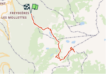
Ruta Senderismo de 22 km a descubrir en Auvergne-Rhône-Alpes, Isère, Revel. Esta ruta ha sido propuesta por flip38.
Descripción
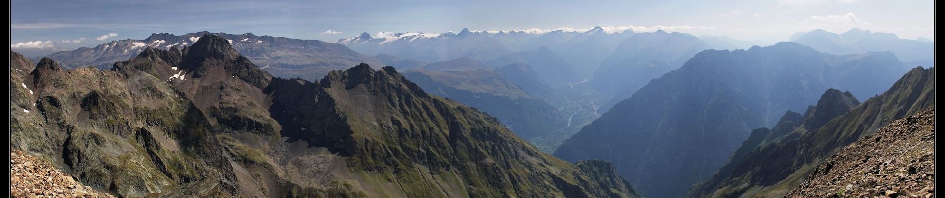
Joli sommet de Belledonne, le panorama est magnifique et on a l'impression d'être sur la lune.
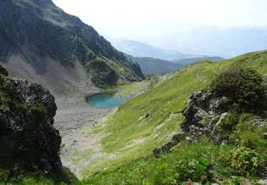
Pas balisé après le lac David, mais sente bien tracée avec des cairns.
Pas mal de dénivelée, randonnée exigeante, ne pas entreprendre par temps de brouillard et en cas de névés tardifs, surtout sous le sommet où l'on traverses des pentes assez raides.
D'autres informations sur mon site : http://surlessommets.blog.free.fr/
Localización
Comentarios
Excursiones cerca
![Excursión A pie La Combe-de-Lancey - Chemin de Découverte (boucle Haute) - Photo](https://media.geolcdn.com/t/375/260/6a0cb0d1-93da-4068-99ad-9a549161cacf.jpeg&format=jpg&maxdim=2)
![A pie A pie](https://static1.geolcdn.com/sitytour/trail-icons/100.png)
A pie
![](/images/other/stat-length.png)
![](https://static1.geolcdn.com/siteimages/upload/files/16400158638029165_repeat_loop_refresh_sync_direction_icon.png)
![Excursión A pie Saint-Jean-le-Vieux - La Tour de Revel (par le Mollard) - Photo](https://media.geolcdn.com/t/375/260/9b2599de-7f79-405c-8210-bdfecfa7c849.jpeg&format=jpg&maxdim=2)
![A pie A pie](https://static1.geolcdn.com/sitytour/trail-icons/100.png)
A pie
![](/images/other/stat-length.png)
![](https://static1.geolcdn.com/siteimages/upload/files/16400158638029165_repeat_loop_refresh_sync_direction_icon.png)
![Excursión Senderismo Saint-Martin-d'Uriage - Les Seiglières. Circuit des Gardes n°9 raccourci à 8 km - Photo](https://media.geolcdn.com/t/375/260/e86aee80-f13d-4d4a-be38-285e5f19658e.jpg&format=jpg&maxdim=2)
![Senderismo Senderismo](https://static1.geolcdn.com/sitytour/trail-icons/101.png)
Senderismo
![](/images/other/stat-length.png)
![](https://static1.geolcdn.com/siteimages/upload/files/16400158638029165_repeat_loop_refresh_sync_direction_icon.png)
![Excursión Senderismo La Combe-de-Lancey - Col du Pré du Molard - Photo](https://media.geolcdn.com/t/375/260/29dc783a-080e-448f-b06b-b4c5ed8fc906.jpg&format=jpg&maxdim=2)
![Senderismo Senderismo](https://static1.geolcdn.com/sitytour/trail-icons/101.png)
Senderismo
![](/images/other/stat-length.png)
![](https://static1.geolcdn.com/siteimages/upload/files/16400158638029165_repeat_loop_refresh_sync_direction_icon.png)
![Excursión Senderismo Saint-Mury-Monteymond - Lac Blanc au pied de Belledonne - Photo](https://media.geolcdn.com/t/375/260/be8bcf54-d056-4226-93e0-f27b8cc25845.jpg&format=jpg&maxdim=2)
![Senderismo Senderismo](https://static1.geolcdn.com/sitytour/trail-icons/101.png)
Senderismo
![](/images/other/stat-length.png)
![](https://static1.geolcdn.com/siteimages/upload/files/16400158638029165_repeat_loop_refresh_sync_direction_icon.png)
![Excursión Senderismo Revel - Montagne 15/08/2023 - Photo](https://media.geolcdn.com/t/375/260/ca509cb3-3847-45e2-a337-c41964fdee08.jpg&format=jpg&maxdim=2)
![Senderismo Senderismo](https://static1.geolcdn.com/sitytour/trail-icons/101.png)
Senderismo
![](/images/other/stat-length.png)
![](https://static1.geolcdn.com/siteimages/upload/files/16400158638029165_repeat_loop_refresh_sync_direction_icon.png)
![Excursión Senderismo Saint-Mury-Monteymond - Col et Pointe de la Sitre - Photo](https://media.geolcdn.com/t/375/260/12aa835d-a61b-4dc5-8899-8748a81192a8.jpg&format=jpg&maxdim=2)
![Senderismo Senderismo](https://static1.geolcdn.com/sitytour/trail-icons/101.png)
Senderismo
![](/images/other/stat-length.png)
![](https://static1.geolcdn.com/siteimages/upload/files/16400158638029165_repeat_loop_refresh_sync_direction_icon.png)
![Excursión Senderismo Saint-Martin-d'Uriage - Circuit des Gardes - Photo](https://media.geolcdn.com/t/375/260/5aace18d-b6a8-46a3-a2a8-ee9515f27ad2.jpg&format=jpg&maxdim=2)
![Senderismo Senderismo](https://static1.geolcdn.com/sitytour/trail-icons/101.png)
Senderismo
![](/images/other/stat-length.png)
![](https://static1.geolcdn.com/siteimages/upload/files/16400158638029165_repeat_loop_refresh_sync_direction_icon.png)
![Senderismo Senderismo](https://static1.geolcdn.com/sitytour/trail-icons/101.png)
Senderismo
![](/images/other/stat-length.png)
![](https://static1.geolcdn.com/siteimages/upload/files/16400158638029165_repeat_loop_refresh_sync_direction_icon.png)