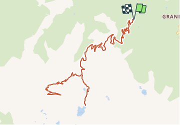
![](/images/other/stat-length.png)
![Excursión Val-Cenis - 2021-09-04_13h46m39_SityTrail - 2706128 - pointe-droset-fort-malamo-lac-blanc - Photo](https://media.geolcdn.com/t/1900/400/ext.pjpeg?maxdim=2&url=https%3A%2F%2Fsecurestorage.geolives.com%2Fsitytour%2Ftrail-bg%2Fdefault.jpg)
2021-09-04_13h46m39_SityTrail - 2706128 - pointe-droset-fort-malamo-lac-blanc
Louna
Usuario
![Longitud](/images/other/stat-length.png)
![Altitud máxima](https://static1.geolcdn.com/siteimages/upload/files/1508320355ic_sort_altitude_max_24dp.png)
![Desnivel positivo](https://static1.geolcdn.com/siteimages/upload/files/1508320355ic_sort_den_pos_24dp.png)
![Km-Effort](/images/other/stat-length.png)
![Altitud mínima](https://static1.geolcdn.com/siteimages/upload/files/1508320355ic_sort_altitude_min_24dp.png)
![Desnivel negativo](https://static1.geolcdn.com/siteimages/upload/files/1508320355ic_sort_den_neg_24dp.png)
![Boucle](https://static1.geolcdn.com/siteimages/upload/files/16400158638029165_repeat_loop_refresh_sync_direction_icon.png)
![Escanee este código QR para abrir la excursión en la aplicación SityTrail](https://capi.geolives.com/qq0zvz2zws4bq2lad0pu/sitytour/trails/2924045/qr.png?size=200)
Aplicación GPS de excursión GRATIS
A propósito
Ruta de 18,4 km a descubrir en Auvergne-Rhône-Alpes, Saboya, Val-Cenis. Esta ruta ha sido propuesta por Louna .
Descripción
Départ: soit Parking vers le barrage du Mt Cenis à 2040m, soit au Parking de la Combe de Crevecoeur.
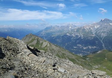
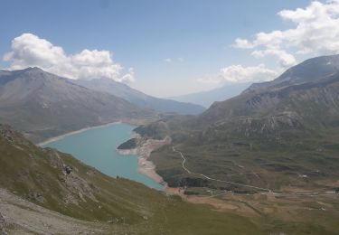
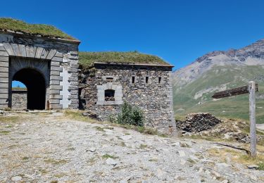
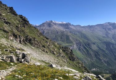
Secteur marqué par l'histoire de la frontière avec de nombreuses friches militaires. Au fort (qui était italien jusqu'en 1890) vue splendide sur les lacs Giasets, le Mont Guisaleth et les montagnes de Bramans et du Mt Cenis
Localización
Comentarios
Excursiones cerca
![Excursión Senderismo Val-Cenis - signal du Petit Mont-Cenis Cenis - Photo](https://media.geolcdn.com/t/375/260/ext.jpg?maxdim=2&url=https%3A%2F%2Fservices.sitytrail.com%2FGeolivesWS%2FDownloadMedia.ashx%3FTrailID%3D615956%26Media%3Dfix__20160817102723.jpg)
![Senderismo Senderismo](https://static1.geolcdn.com/sitytour/trail-icons/101.png)
Senderismo
![](/images/other/stat-length.png)
![](https://static1.geolcdn.com/siteimages/upload/files/16400158638029165_repeat_loop_refresh_sync_direction_icon.png)
![Excursión sport Val-Cenis - L’ancien fort de la Turra - Photo](https://media.geolcdn.com/t/375/260/2f372af5-3d13-4f3d-be22-d2d73efaca61.jpg&format=jpg&maxdim=2)
sport
![](/images/other/stat-length.png)
![](https://static1.geolcdn.com/siteimages/upload/files/16400158638029165_repeat_loop_refresh_sync_direction_icon.png)
![Excursión Senderismo Val-Cenis - Montcenis lac fort de la Tura - Photo](https://media.geolcdn.com/t/375/260/03903eba-f11b-41f0-bc93-d99cacc6c53d.jpg&format=jpg&maxdim=2)
![Senderismo Senderismo](https://static1.geolcdn.com/sitytour/trail-icons/101.png)
Senderismo
![](/images/other/stat-length.png)
![](https://static1.geolcdn.com/siteimages/upload/files/16400158638029165_repeat_loop_refresh_sync_direction_icon.png)
![Excursión Senderismo Val-Cenis - Refuge du petit Mont-Cenis - Col de Bellecombe - Photo](https://media.geolcdn.com/t/375/260/6ef1a6b7-2407-4d68-aa00-60607ba7429d.jpg&format=jpg&maxdim=2)
![Senderismo Senderismo](https://static1.geolcdn.com/sitytour/trail-icons/101.png)
Senderismo
![](/images/other/stat-length.png)
![](https://static1.geolcdn.com/siteimages/upload/files/16400158638029165_repeat_loop_refresh_sync_direction_icon.png)
![Excursión Senderismo Val-Cenis - Le Fort de la Turra - Photo](https://media.geolcdn.com/t/375/260/fb7e4b15-499e-46a6-93e3-9848cd5c0804.jpg&format=jpg&maxdim=2)
![Senderismo Senderismo](https://static1.geolcdn.com/sitytour/trail-icons/101.png)
Senderismo
![](/images/other/stat-length.png)
![](https://static1.geolcdn.com/siteimages/upload/files/16400158638029165_repeat_loop_refresh_sync_direction_icon.png)
![Excursión Senderismo Val-Cenis - fort de la Turra - col de la Beccia - Photo](https://media.geolcdn.com/t/375/260/519bc2cf-9575-4c95-8b89-a32fb03a43b6.jpg&format=jpg&maxdim=2)
![Senderismo Senderismo](https://static1.geolcdn.com/sitytour/trail-icons/101.png)
Senderismo
![](/images/other/stat-length.png)
![](https://static1.geolcdn.com/siteimages/upload/files/16400158638029165_repeat_loop_refresh_sync_direction_icon.png)
![Excursión Senderismo Val-Cenis - Savoie_Val-Cenis_Lac de l'Arcelle - Photo](https://media.geolcdn.com/t/375/260/94347fc6-b8c5-42c0-a18f-2fed8afa226d.jpg&format=jpg&maxdim=2)
![Senderismo Senderismo](https://static1.geolcdn.com/sitytour/trail-icons/101.png)
Senderismo
![](/images/other/stat-length.png)
![](https://static1.geolcdn.com/siteimages/upload/files/16400158638029165_repeat_loop_refresh_sync_direction_icon.png)
![Excursión Senderismo Val-Cenis - Savoie_Barrage-du-Mont-Cenis=>Fort-de-Variselle - Photo](https://media.geolcdn.com/t/375/260/36826a87-c81d-464b-bf46-c61bb879976c.jpg&format=jpg&maxdim=2)
![Senderismo Senderismo](https://static1.geolcdn.com/sitytour/trail-icons/101.png)
Senderismo
![](/images/other/stat-length.png)
![](https://static1.geolcdn.com/siteimages/upload/files/16400158638029165_repeat_loop_refresh_sync_direction_icon.png)
![Excursión Senderismo Val-Cenis - Mont Giusalet - Photo](https://media.geolcdn.com/t/375/260/b8d02cf7-fe95-4e1a-a346-e2b3a0da8597.jpg&format=jpg&maxdim=2)
![Senderismo Senderismo](https://static1.geolcdn.com/sitytour/trail-icons/101.png)
Senderismo
![](/images/other/stat-length.png)
![](https://static1.geolcdn.com/siteimages/upload/files/16400158638029165_repeat_loop_refresh_sync_direction_icon.png)