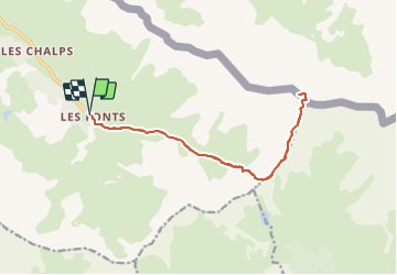
![](/images/other/stat-length.png)
![Excursión Senderismo Cervières - Le Grand Gleiza - Photo](https://media.geolcdn.com/t/1900/400/ext.pjpeg?maxdim=2&url=https%3A%2F%2Fstatic1.geolcdn.com%2Fsiteimages%2Fupload%2Ffiles%2F1553511878bg_sport_marche.png)
Le Grand Gleiza
Dervalmarc
Usuario
![Longitud](/images/other/stat-length.png)
![Altitud máxima](https://static1.geolcdn.com/siteimages/upload/files/1508320355ic_sort_altitude_max_24dp.png)
![Desnivel positivo](https://static1.geolcdn.com/siteimages/upload/files/1508320355ic_sort_den_pos_24dp.png)
![Km-Effort](/images/other/stat-length.png)
![Altitud mínima](https://static1.geolcdn.com/siteimages/upload/files/1508320355ic_sort_altitude_min_24dp.png)
![Desnivel negativo](https://static1.geolcdn.com/siteimages/upload/files/1508320355ic_sort_den_neg_24dp.png)
![Boucle](https://static1.geolcdn.com/siteimages/upload/files/16400158638029165_repeat_loop_refresh_sync_direction_icon.png)
![Senderismo](https://static1.geolcdn.com/sitytour/trail-icons/101.png)
22h34
Dificultad : Muy difícil
![Escanee este código QR para abrir la excursión en la aplicación SityTrail](https://capi.geolives.com/qq0zvz2zws4bq2lad0pu/sitytour/trails/2914264/qr.png?size=200)
Aplicación GPS de excursión GRATIS
A propósito
Ruta Senderismo de 15,8 km a descubrir en Provenza-Alpes-Costa Azul, Altos Alpes, Cervières. Esta ruta ha sido propuesta por Dervalmarc.
Descripción
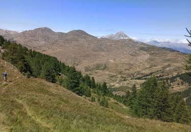
Très longue randonnée.
20 kilomètres.
Très variée.2 cimes, deux col.
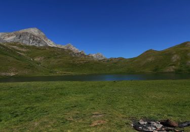
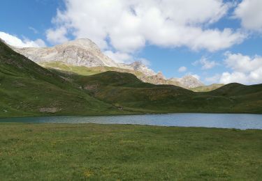
Vue sur le grand lac du Laus.
Compter entre huit et 10 heures de marche arrêts non compris.
Panorama exceptionnel bien mérité après une ascension exigeante.
Compter 10h de marche et non 22h37
Localización
Comentarios
Excursiones cerca
![Excursión Senderismo Cervières - Le Petit rochebrune par col de péas - Photo](https://media.geolcdn.com/t/375/260/e12553c6-5b67-4a21-b5b9-83e83e9c9741.jpg&format=jpg&maxdim=2)
![Senderismo Senderismo](https://static1.geolcdn.com/sitytour/trail-icons/101.png)
Senderismo
![](/images/other/stat-length.png)
![](https://static1.geolcdn.com/siteimages/upload/files/16400158638029165_repeat_loop_refresh_sync_direction_icon.png)
![Excursión Senderismo Cervières - le lac des Cordes et le pic du vallon Crouzet - Photo](https://media.geolcdn.com/t/375/260/ext.jpg?maxdim=2&url=https%3A%2F%2Fservices.sitytrail.com%2FGeolivesWS%2FDownloadMedia.ashx%3FTrailID%3D787861%26Media%3Dfix__20170710153913.jpg)
![Senderismo Senderismo](https://static1.geolcdn.com/sitytour/trail-icons/101.png)
Senderismo
![](/images/other/stat-length.png)
![](https://static1.geolcdn.com/siteimages/upload/files/16400158638029165_repeat_loop_refresh_sync_direction_icon.png)
![Excursión Senderismo Cervières - Circuit du Lac des Cordes - Photo](https://media.geolcdn.com/t/375/260/773a9233-b719-442d-b7b1-75196ce74f87.jpg&format=jpg&maxdim=2)
![Senderismo Senderismo](https://static1.geolcdn.com/sitytour/trail-icons/101.png)
Senderismo
![](/images/other/stat-length.png)
![](https://static1.geolcdn.com/siteimages/upload/files/16400158638029165_repeat_loop_refresh_sync_direction_icon.png)
![Excursión Esquí de fondo Cervières - PT 2944 crête de Dormillouse - Photo](https://media.geolcdn.com/t/375/260/9199c634-7f71-48f6-bcd5-441d1eaab9cb.jpg&format=jpg&maxdim=2)
![Esquí de fondo Esquí de fondo](https://static1.geolcdn.com/sitytour/trail-icons/503.png)
Esquí de fondo
![](/images/other/stat-length.png)
![](https://static1.geolcdn.com/siteimages/upload/files/16400158638029165_repeat_loop_refresh_sync_direction_icon.png)
![Excursión Senderismo Cervières - le lasseron col de chaude maison - Photo](https://media.geolcdn.com/t/375/260/a0498023-fd7f-45a6-ba40-c354c806ca60.jpg&format=jpg&maxdim=2)
![Senderismo Senderismo](https://static1.geolcdn.com/sitytour/trail-icons/101.png)
Senderismo
![](/images/other/stat-length.png)
![](https://static1.geolcdn.com/siteimages/upload/files/16400158638029165_repeat_loop_refresh_sync_direction_icon.png)
![Excursión Senderismo Cervières - Le Lac des cordes - Photo](https://media.geolcdn.com/t/375/260/4677ed4c-abf4-4114-9dfd-57192ba7a290.jpg&format=jpg&maxdim=2)
![Senderismo Senderismo](https://static1.geolcdn.com/sitytour/trail-icons/101.png)
Senderismo
![](/images/other/stat-length.png)
![](https://static1.geolcdn.com/siteimages/upload/files/16400158638029165_repeat_loop_refresh_sync_direction_icon.png)
![Excursión Senderismo Cervières - Arsem Les fonts de Cervieres - Photo](https://media.geolcdn.com/t/375/260/1c663feb-cf6d-4c05-adc4-11e78d8381cd.jpg&format=jpg&maxdim=2)
![Senderismo Senderismo](https://static1.geolcdn.com/sitytour/trail-icons/101.png)
Senderismo
![](/images/other/stat-length.png)
![](https://static1.geolcdn.com/siteimages/upload/files/16400158638029165_repeat_loop_refresh_sync_direction_icon.png)
![Excursión Trineo Cervières - refuge Les Fonts à Chalp - Photo](https://media.geolcdn.com/t/375/260/1095cc6d-0fa6-427a-8540-75f35ae6c8dc.jpg&format=jpg&maxdim=2)
![Trineo Trineo](https://static1.geolcdn.com/sitytour/trail-icons/506.png)
Trineo
![](/images/other/stat-length.png)
![](https://static1.geolcdn.com/siteimages/upload/files/16400158638029165_repeat_loop_refresh_sync_direction_icon.png)
![Excursión Senderismo Cervières - Lac des Cordes - Photo](https://media.geolcdn.com/t/375/260/89c8f3fc-bf2f-4ed0-a763-182170a8be7f.jpg&format=jpg&maxdim=2)
![Senderismo Senderismo](https://static1.geolcdn.com/sitytour/trail-icons/101.png)
Senderismo
![](/images/other/stat-length.png)
![](https://static1.geolcdn.com/siteimages/upload/files/16400158638029165_repeat_loop_refresh_sync_direction_icon.png)