


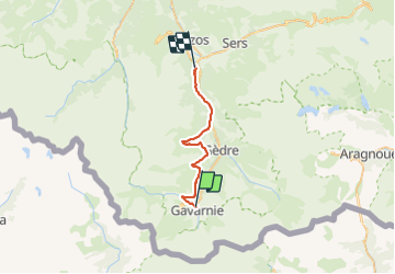

12,1 km | 22 km-effort

Usuario


Aplicación GPS de excursión GRATIS
 SityTrail
IGN / Institutos geográficos
SityTrail World
El mundo es suyo
Ruta Senderismo de 27 km a descubrir en Occitania, Altos-Pirineos, Gavarnie-Gèdre. Esta ruta ha sido propuesta por LEGUE.
On partait pour une petite journée … on s’est retrouvé avec une fois encore une grosse journée !
Grand beau


Senderismo

Senderismo

Senderismo

Senderismo

Senderismo

Paseo ecuestre

Senderismo
Senderismo
Senderismo