![](/images/other/stat-length.png)
![Excursión Senderismo Val-d'Isère - pointe de la Sana - Photo](https://media.geolcdn.com/t/1900/400/2a13a8e9-1e27-484a-a9e6-39b0a4ff9c6e.jpg&format=pjpeg&maxdim=2)
pointe de la Sana
amiral13
Usuario GUIDE
![Longitud](/images/other/stat-length.png)
![Altitud máxima](https://static1.geolcdn.com/siteimages/upload/files/1508320355ic_sort_altitude_max_24dp.png)
![Desnivel positivo](https://static1.geolcdn.com/siteimages/upload/files/1508320355ic_sort_den_pos_24dp.png)
![Km-Effort](/images/other/stat-length.png)
![Altitud mínima](https://static1.geolcdn.com/siteimages/upload/files/1508320355ic_sort_altitude_min_24dp.png)
![Desnivel negativo](https://static1.geolcdn.com/siteimages/upload/files/1508320355ic_sort_den_neg_24dp.png)
![Boucle](https://static1.geolcdn.com/siteimages/upload/files/16400158638029165_repeat_loop_refresh_sync_direction_icon.png)
![Senderismo](https://static1.geolcdn.com/sitytour/trail-icons/101.png)
7h03
Dificultad : Muy difícil
![Escanee este código QR para abrir la excursión en la aplicación SityTrail](https://capi.geolives.com/qq0zvz2zws4bq2lad0pu/sitytour/trails/2908554/qr.png?size=200)
Aplicación GPS de excursión GRATIS
A propósito
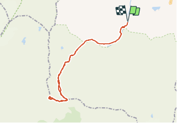
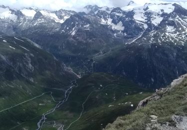
Ruta Senderismo de 18,4 km a descubrir en Auvergne-Rhône-Alpes, Saboya, Val-d'Isère. Esta ruta ha sido propuesta por amiral13.
Descripción
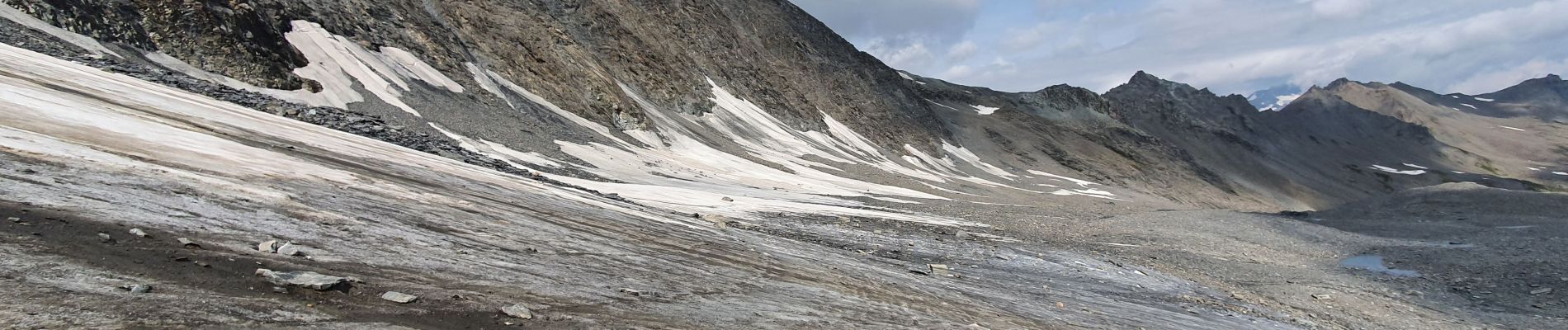
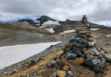
Il s'agit d'une course d'alpinisme, d'où le classement en randonnée très difficile.
En début de saison, il sera nécessaire de prendre tout l'équipement : corde piolet crampons.
En fin de saison, seuls les crampons seront utiles pour la portion de glacier qui n'est pas recouverte de pierres. Il est plus difficile de trouver le bon itinéraire dans le dédale de pierriers qui recouvre le glacier; de même le pierrier qui remplace le glacier de la Sana peut-être éprouvant.
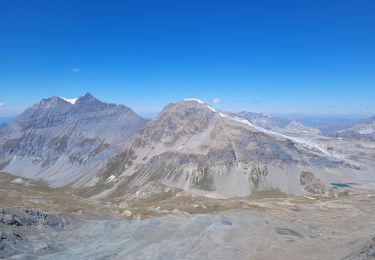
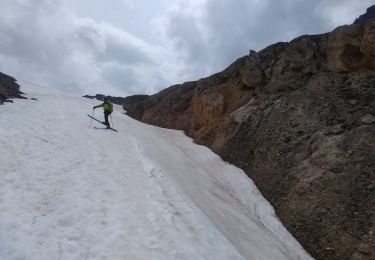
Localización
Comentarios
Excursiones cerca
![Excursión Senderismo Val-d'Isère - rocher du Charvet - Photo](https://media.geolcdn.com/t/375/260/695e5e9f-e8dc-4cf9-b576-ab38f18a42af.jpg&format=jpg&maxdim=2)
![Senderismo Senderismo](https://static1.geolcdn.com/sitytour/trail-icons/101.png)
Senderismo
![](/images/other/stat-length.png)
![](https://static1.geolcdn.com/siteimages/upload/files/16400158638029165_repeat_loop_refresh_sync_direction_icon.png)
![Excursión Senderismo Val-d'Isère - Les cascades des salins au départ de val d’Isère - Photo](https://media.geolcdn.com/t/375/260/c3b76218-f72c-4eeb-8155-41f32eab8f13.jpg&format=jpg&maxdim=2)
![Senderismo Senderismo](https://static1.geolcdn.com/sitytour/trail-icons/101.png)
Senderismo
![](/images/other/stat-length.png)
![](https://static1.geolcdn.com/siteimages/upload/files/16400158638029165_repeat_loop_refresh_sync_direction_icon.png)
![Excursión Senderismo Val-d'Isère - pointe de la Sana - Photo](https://media.geolcdn.com/t/375/260/cf1c2ddd-8e22-4533-8c04-6fcf89140ded.jpg&format=jpg&maxdim=2)
![Senderismo Senderismo](https://static1.geolcdn.com/sitytour/trail-icons/101.png)
Senderismo
![](/images/other/stat-length.png)
![](https://static1.geolcdn.com/siteimages/upload/files/16400158638029165_repeat_loop_refresh_sync_direction_icon.png)
![Excursión Senderismo Val-d'Isère - Lac, col et pointe de la Bailletaz - Photo](https://media.geolcdn.com/t/375/260/9d40bc9e-390f-4a5e-a6f3-053ea09f211b.jpg&format=jpg&maxdim=2)
![Senderismo Senderismo](https://static1.geolcdn.com/sitytour/trail-icons/101.png)
Senderismo
![](/images/other/stat-length.png)
![](https://static1.geolcdn.com/siteimages/upload/files/16400158638029165_repeat_loop_refresh_sync_direction_icon.png)
![Excursión Esquí de fondo Bonneval-sur-Arc - col de Calabourdane, pointe nord de Bézin, col de Bézin - Photo](https://media.geolcdn.com/t/375/260/82b2df5e-dc5e-48f0-b4d4-d10398fafa9d.jpg&format=jpg&maxdim=2)
![Esquí de fondo Esquí de fondo](https://static1.geolcdn.com/sitytour/trail-icons/503.png)
Esquí de fondo
![](/images/other/stat-length.png)
![](https://static1.geolcdn.com/siteimages/upload/files/16400158638029165_repeat_loop_refresh_sync_direction_icon.png)
![Excursión Esquí de fondo Bonneval-sur-Arc - Tricotage au col de l'iseran - Photo](https://media.geolcdn.com/t/375/260/82300eb0-c716-486e-a37a-4e5efd5b3f81.jpg&format=jpg&maxdim=2)
![Esquí de fondo Esquí de fondo](https://static1.geolcdn.com/sitytour/trail-icons/503.png)
Esquí de fondo
![](/images/other/stat-length.png)
![](https://static1.geolcdn.com/siteimages/upload/files/16400158638029165_repeat_loop_refresh_sync_direction_icon.png)
![Excursión Senderismo Val-d'Isère - pointe de Méan Martin - Photo](https://media.geolcdn.com/t/375/260/e7b21b02-f5f9-4e0b-a59b-b8dbed1fe073.jpg&format=jpg&maxdim=2)
![Senderismo Senderismo](https://static1.geolcdn.com/sitytour/trail-icons/101.png)
Senderismo
![](/images/other/stat-length.png)
![](https://static1.geolcdn.com/siteimages/upload/files/16400158638029165_repeat_loop_refresh_sync_direction_icon.png)
![Excursión Senderismo Bonneval-sur-Arc - signal de l'Iseran - Photo](https://media.geolcdn.com/t/375/260/9c28b77f-4f31-4715-9b89-c8be4cd958bd.jpg&format=jpg&maxdim=2)
![Senderismo Senderismo](https://static1.geolcdn.com/sitytour/trail-icons/101.png)
Senderismo
![](/images/other/stat-length.png)
![](https://static1.geolcdn.com/siteimages/upload/files/16400158638029165_repeat_loop_refresh_sync_direction_icon.png)
![Excursión Senderismo Val-d'Isère - tour du Roc de la Tovière - Photo](https://media.geolcdn.com/t/375/260/ext.jpg?maxdim=2&url=https%3A%2F%2Fservices.sitytrail.com%2FGeolivesWS%2FDownloadMedia.ashx%3FTrailID%3D460816%26Media%3Ddb595cb6-19b2-4ef9-ad15-ba4627b1a709.JPG)
![Senderismo Senderismo](https://static1.geolcdn.com/sitytour/trail-icons/101.png)
Senderismo
![](/images/other/stat-length.png)
![](https://static1.geolcdn.com/siteimages/upload/files/16400158638029165_repeat_loop_refresh_sync_direction_icon.png)