![](/images/other/stat-length.png)
![Excursión Senderismo Bangor - port Coton- Foyt Sarah Bernhart - Photo](https://media.geolcdn.com/t/1900/400/ext.pjpeg?maxdim=2&url=https%3A%2F%2Fstatic1.geolcdn.com%2Fsiteimages%2Fupload%2Ffiles%2F1553511878bg_sport_marche.png)
port Coton- Foyt Sarah Bernhart
DuMarsan
Usuario
![Longitud](/images/other/stat-length.png)
Longitud
19,1 km
![Altitud máxima](https://static1.geolcdn.com/siteimages/upload/files/1508320355ic_sort_altitude_max_24dp.png)
Altitud máxima
41 m
![Desnivel positivo](https://static1.geolcdn.com/siteimages/upload/files/1508320355ic_sort_den_pos_24dp.png)
Desnivel positivo
329 m
![Km-Effort](/images/other/stat-length.png)
Km-Effort
23 km
![Altitud mínima](https://static1.geolcdn.com/siteimages/upload/files/1508320355ic_sort_altitude_min_24dp.png)
Altitud mínima
0 m
![Desnivel negativo](https://static1.geolcdn.com/siteimages/upload/files/1508320355ic_sort_den_neg_24dp.png)
Desnivel negativo
323 m
![Boucle](https://static1.geolcdn.com/siteimages/upload/files/16400158638029165_repeat_loop_refresh_sync_direction_icon.png)
Boucle
No
Fecha de creación :
2021-08-16 06:57:43.794
Última modificación :
2021-08-16 15:49:08.804
![Senderismo](https://static1.geolcdn.com/sitytour/trail-icons/101.png)
6h46
Dificultad : Medio
![Escanee este código QR para abrir la excursión en la aplicación SityTrail](https://capi.geolives.com/qq0zvz2zws4bq2lad0pu/sitytour/trails/2900851/qr.png?size=200)
Aplicación GPS de excursión GRATIS
A propósito
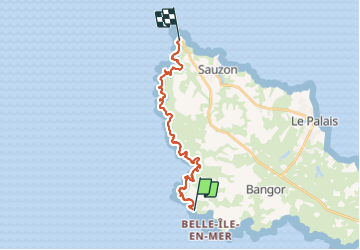
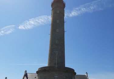
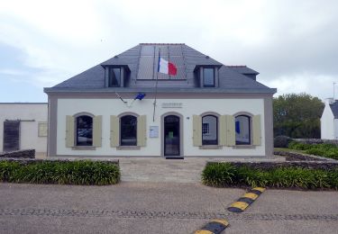
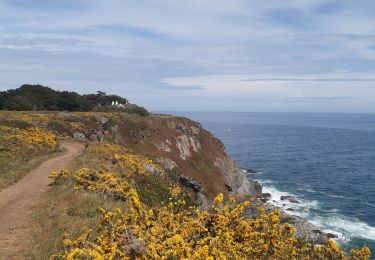
Ruta Senderismo de 19,1 km a descubrir en Bretaña, Morbihan, Bangor. Esta ruta ha sido propuesta por DuMarsan.
Descripción
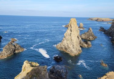
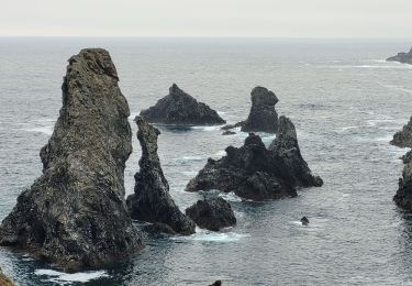
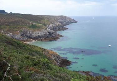
parcours très sauvage. Côte déchiquetée. Succession d anses longues et profondes. Prévoir de quoi manger et boire sur le sentier.
Localización
País:
France
Región :
Bretaña
Departamento/provincia :
Morbihan
Municipio :
Bangor
Localidad:
Unknown
Salida:(Dec)
Salida:(UTM)
482039 ; 5239109 (30T) N.
Comentarios
Excursiones cerca
![Excursión Senderismo Bangor - bangor - Photo](https://media.geolcdn.com/t/375/260/ext.jpg?maxdim=2&url=https%3A%2F%2Fservices.sitytrail.com%2FGeolivesWS%2FDownloadMedia.ashx%3FTrailID%3D308558%26Media%3Dfix__20140530104824.jpg)
![Senderismo Senderismo](https://static1.geolcdn.com/sitytour/trail-icons/101.png)
bangor
Senderismo
Muy fácil
(1)
Bangor,
Bretaña,
Morbihan,
France
![](/images/other/stat-length.png)
9,4 km | 11,2 km-effort
2h 40min
![](https://static1.geolcdn.com/siteimages/upload/files/16400158638029165_repeat_loop_refresh_sync_direction_icon.png)
Sí
![Excursión Senderismo Bangor - Belle île en mer - Photo](https://media.geolcdn.com/t/375/260/3a7f4183-98be-4dc7-9aad-ed1e320f25b2.jpg&format=jpg&maxdim=2)
![Senderismo Senderismo](https://static1.geolcdn.com/sitytour/trail-icons/101.png)
Belle île en mer
Senderismo
Muy difícil
Bangor,
Bretaña,
Morbihan,
France
![](/images/other/stat-length.png)
64 km | 82 km-effort
15h 44min
![](https://static1.geolcdn.com/siteimages/upload/files/16400158638029165_repeat_loop_refresh_sync_direction_icon.png)
No
![Excursión Senderismo Bangor - J3 - Port Coton - Locmaria - 24 km - Photo](https://media.geolcdn.com/t/375/260/ext.jpg?maxdim=2&url=https%3A%2F%2Fstatic1.geolcdn.com%2Fsiteimages%2Fupload%2Ffiles%2F1553511878bg_sport_marche.png)
![Senderismo Senderismo](https://static1.geolcdn.com/sitytour/trail-icons/101.png)
J3 - Port Coton - Locmaria - 24 km
Senderismo
Muy difícil
(1)
Bangor,
Bretaña,
Morbihan,
France
![](/images/other/stat-length.png)
24 km | 31 km-effort
7h 3min
![](https://static1.geolcdn.com/siteimages/upload/files/16400158638029165_repeat_loop_refresh_sync_direction_icon.png)
No
![Excursión Senderismo Bangor - 2-Port Coton - l'Apothicairerie à Belle Île en mer - Photo](https://media.geolcdn.com/t/375/260/5b3aba3d-6201-477b-b54e-bfc76b8e3758.jpg&format=jpg&maxdim=2)
![Senderismo Senderismo](https://static1.geolcdn.com/sitytour/trail-icons/101.png)
2-Port Coton - l'Apothicairerie à Belle Île en mer
Senderismo
Medio
Bangor,
Bretaña,
Morbihan,
France
![](/images/other/stat-length.png)
13,7 km | 17,2 km-effort
2h 50min
![](https://static1.geolcdn.com/siteimages/upload/files/16400158638029165_repeat_loop_refresh_sync_direction_icon.png)
No
![Excursión Senderismo Bangor - 3-Port Coton - Locmaria à Belle Île en mer - Photo](https://media.geolcdn.com/t/375/260/61d9dfb6-e967-452b-8601-de89fcd53ae3.jpg&format=jpg&maxdim=2)
![Senderismo Senderismo](https://static1.geolcdn.com/sitytour/trail-icons/101.png)
3-Port Coton - Locmaria à Belle Île en mer
Senderismo
Medio
Bangor,
Bretaña,
Morbihan,
France
![](/images/other/stat-length.png)
25 km | 33 km-effort
5h 5min
![](https://static1.geolcdn.com/siteimages/upload/files/16400158638029165_repeat_loop_refresh_sync_direction_icon.png)
No
![Excursión Senderismo Bangor - GR340 BELLE-ILE jour 3 - Grand Large - Locmaria - Photo](https://media.geolcdn.com/t/375/260/8b1423fb-d98c-4bac-8258-679bd03de44c.jpg&format=jpg&maxdim=2)
![Senderismo Senderismo](https://static1.geolcdn.com/sitytour/trail-icons/101.png)
GR340 BELLE-ILE jour 3 - Grand Large - Locmaria
Senderismo
Difícil
Bangor,
Bretaña,
Morbihan,
France
![](/images/other/stat-length.png)
25 km | 32 km-effort
8h 5min
![](https://static1.geolcdn.com/siteimages/upload/files/16400158638029165_repeat_loop_refresh_sync_direction_icon.png)
No
![Excursión Senderismo Bangor - aiguilles de port Cotton - Photo](https://media.geolcdn.com/t/375/260/351bb440-7c45-45af-8626-d2213c10b99a.jpg&format=jpg&maxdim=2)
![Senderismo Senderismo](https://static1.geolcdn.com/sitytour/trail-icons/101.png)
aiguilles de port Cotton
Senderismo
Fácil
Bangor,
Bretaña,
Morbihan,
France
![](/images/other/stat-length.png)
6,6 km | 7,9 km-effort
2h 3min
![](https://static1.geolcdn.com/siteimages/upload/files/16400158638029165_repeat_loop_refresh_sync_direction_icon.png)
Sí
![Excursión A pie Bangor - Sentier du Stang Per - Photo](https://media.geolcdn.com/t/375/260/79d44e98-b1d5-40ac-81c7-6fc59deba8b2.jpeg&format=jpg&maxdim=2)
![A pie A pie](https://static1.geolcdn.com/sitytour/trail-icons/100.png)
![Excursión Senderismo Bangor - port cotton,Locmaria - Photo](https://media.geolcdn.com/t/375/260/8341e71a-a817-404b-9455-cd0135701718.jpg&format=jpg&maxdim=2)
![Senderismo Senderismo](https://static1.geolcdn.com/sitytour/trail-icons/101.png)
port cotton,Locmaria
Senderismo
Medio
Bangor,
Bretaña,
Morbihan,
France
![](/images/other/stat-length.png)
19,6 km | 26 km-effort
5h 11min
![](https://static1.geolcdn.com/siteimages/upload/files/16400158638029165_repeat_loop_refresh_sync_direction_icon.png)
No