![](/images/other/stat-length.png)
![Excursión Senderismo Chorges - Chorges montagne du bois du Ruban - Photo](https://media.geolcdn.com/t/1900/400/7415fcf2-9504-4ff2-aa91-ef2d2f5ab8c2.jpg&format=pjpeg&maxdim=2)
Chorges montagne du bois du Ruban
jll7513
Usuario
![Longitud](/images/other/stat-length.png)
![Altitud máxima](https://static1.geolcdn.com/siteimages/upload/files/1508320355ic_sort_altitude_max_24dp.png)
![Desnivel positivo](https://static1.geolcdn.com/siteimages/upload/files/1508320355ic_sort_den_pos_24dp.png)
![Km-Effort](/images/other/stat-length.png)
![Altitud mínima](https://static1.geolcdn.com/siteimages/upload/files/1508320355ic_sort_altitude_min_24dp.png)
![Desnivel negativo](https://static1.geolcdn.com/siteimages/upload/files/1508320355ic_sort_den_neg_24dp.png)
![Boucle](https://static1.geolcdn.com/siteimages/upload/files/16400158638029165_repeat_loop_refresh_sync_direction_icon.png)
![Senderismo](https://static1.geolcdn.com/sitytour/trail-icons/101.png)
3h52
Dificultad : Medio
![Marcha nórdica](https://static1.geolcdn.com/sitytour/trail-icons/102.png)
2h19
Dificultad : Medio
![Escanee este código QR para abrir la excursión en la aplicación SityTrail](https://capi.geolives.com/qq0zvz2zws4bq2lad0pu/sitytour/trails/2900004/qr.png?size=200)
Aplicación GPS de excursión GRATIS
A propósito
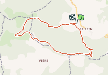
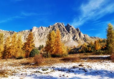
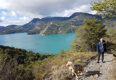
Ruta Senderismo de 10,7 km a descubrir en Provenza-Alpes-Costa Azul, Altos Alpes, Chorges. Esta ruta ha sido propuesta por jll7513.
Descripción
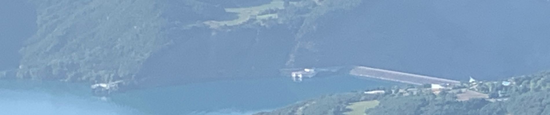
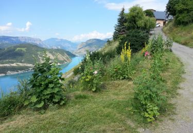
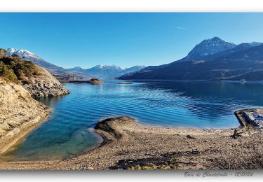
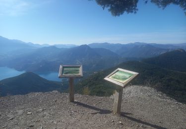
On peut se garer sur le bord de la route, la randonnée démarre du lieu de parking. Les 2 premiers kms sont assez pentus, surtout bien rester sur la rive droite du torrent. On passe à La Croix à la mémoire des combattants de la résistance. Ensuite on bascule coté lac de Serre Ponçon avec une très belle vue sur le barrage depuis le panorama du ruban avec ses 2 tables d'orientation. Un circuit bien ombragé sur des sentiers et des pistes forestières.
Localización
Comentarios
Excursiones cerca
![Excursión Senderismo Chorges - Chanteloube et lac de Serre Ponçon - Photo](https://media.geolcdn.com/t/375/260/ext.jpg?maxdim=2&url=https%3A%2F%2Fservices.sitytrail.com%2FGeolivesWS%2FDownloadMedia.ashx%3FTrailID%3D337864%26Media%3Dfix__20140822114842.jpg)
![Senderismo Senderismo](https://static1.geolcdn.com/sitytour/trail-icons/101.png)
Senderismo
![](/images/other/stat-length.png)
![](https://static1.geolcdn.com/siteimages/upload/files/16400158638029165_repeat_loop_refresh_sync_direction_icon.png)
![Excursión Senderismo Chorges - clôt c l'avais sur fein - Photo](https://media.geolcdn.com/t/375/260/ext.jpg?maxdim=2&url=https%3A%2F%2Fservices.sitytrail.com%2FGeolivesWS%2FDownloadMedia.ashx%3FTrailID%3D306998%26Media%3Dfix__20140529172433.jpg)
![Senderismo Senderismo](https://static1.geolcdn.com/sitytour/trail-icons/101.png)
Senderismo
![](/images/other/stat-length.png)
![](https://static1.geolcdn.com/siteimages/upload/files/16400158638029165_repeat_loop_refresh_sync_direction_icon.png)
![Excursión Senderismo Le Sauze-du-Lac - Embrunais - le Sauze-du-Lac Port St-Pierre - 5.1km 280m 1h45 - 2018 06 29 - public - Photo](https://media.geolcdn.com/t/375/260/ext.jpg?maxdim=2&url=https%3A%2F%2Fservices.sitytrail.com%2FGeolivesWS%2FDownloadMedia.ashx%3FTrailID%3D999114%26Media%3Dfix__20180629102822.jpg)
![Senderismo Senderismo](https://static1.geolcdn.com/sitytour/trail-icons/101.png)
Senderismo
![](/images/other/stat-length.png)
![](https://static1.geolcdn.com/siteimages/upload/files/16400158638029165_repeat_loop_refresh_sync_direction_icon.png)
![Excursión Senderismo Chorges - Montagne du Ruban - Photo](https://media.geolcdn.com/t/375/260/ext.jpg?maxdim=2&url=https%3A%2F%2Fstatic1.geolcdn.com%2Fsiteimages%2Fupload%2Ffiles%2F1553511878bg_sport_marche.png)
![Senderismo Senderismo](https://static1.geolcdn.com/sitytour/trail-icons/101.png)
Senderismo
![](/images/other/stat-length.png)
![](https://static1.geolcdn.com/siteimages/upload/files/16400158638029165_repeat_loop_refresh_sync_direction_icon.png)
![Excursión Senderismo Chorges - De-chanteloube-a-saint-michel-retour-par-le-belvedere-des-curattes - Photo](https://media.geolcdn.com/t/375/260/30a4afde-c6d7-4d24-9e6c-05905d1a1dbf.jpg&format=jpg&maxdim=2)
![Senderismo Senderismo](https://static1.geolcdn.com/sitytour/trail-icons/101.png)
Senderismo
![](/images/other/stat-length.png)
![](https://static1.geolcdn.com/siteimages/upload/files/16400158638029165_repeat_loop_refresh_sync_direction_icon.png)
![Excursión Senderismo Prunières - visorando-trou-de-pancrace-serre-du-mouton-et-griffes-du-lion-rose-de-salados - Photo](https://media.geolcdn.com/t/375/260/9d97d252-9ee1-4c2d-aad4-6eef70e11633.jpg&format=jpg&maxdim=2)
![Senderismo Senderismo](https://static1.geolcdn.com/sitytour/trail-icons/101.png)
Senderismo
![](/images/other/stat-length.png)
![](https://static1.geolcdn.com/siteimages/upload/files/16400158638029165_repeat_loop_refresh_sync_direction_icon.png)
![Excursión Senderismo Le Sauze-du-Lac - Balcons du lac Taïga - Photo](https://media.geolcdn.com/t/375/260/78801efe-4ea5-4d79-aa98-ade291d85566.jpg&format=jpg&maxdim=2)
![Senderismo Senderismo](https://static1.geolcdn.com/sitytour/trail-icons/101.png)
Senderismo
![](/images/other/stat-length.png)
![](https://static1.geolcdn.com/siteimages/upload/files/16400158638029165_repeat_loop_refresh_sync_direction_icon.png)
![Excursión Senderismo Chorges - Clôt Clavary 3.9.23 - Photo](https://media.geolcdn.com/t/375/260/e339989a-4af8-4e0a-b588-3657ae86e079.jpg&format=jpg&maxdim=2)
![Senderismo Senderismo](https://static1.geolcdn.com/sitytour/trail-icons/101.png)
Senderismo
![](/images/other/stat-length.png)
![](https://static1.geolcdn.com/siteimages/upload/files/16400158638029165_repeat_loop_refresh_sync_direction_icon.png)
![Excursión Paseo ecuestre Prunières - Le pomeyret avec Ziton - Photo](https://media.geolcdn.com/t/375/260/9e10b878-d3a3-48c5-bb28-52b76372bd5f.jpg&format=jpg&maxdim=2)
![Paseo ecuestre Paseo ecuestre](https://static1.geolcdn.com/sitytour/trail-icons/301.png)
Paseo ecuestre
![](/images/other/stat-length.png)
![](https://static1.geolcdn.com/siteimages/upload/files/16400158638029165_repeat_loop_refresh_sync_direction_icon.png)