![](/images/other/stat-length.png)
![Excursión Senderismo Val-d'Isère - rocher du Charvet - Photo](https://media.geolcdn.com/t/1900/400/695e5e9f-e8dc-4cf9-b576-ab38f18a42af.jpg&format=pjpeg&maxdim=2)
rocher du Charvet
amiral13
Usuario GUIDE
![Longitud](/images/other/stat-length.png)
![Altitud máxima](https://static1.geolcdn.com/siteimages/upload/files/1508320355ic_sort_altitude_max_24dp.png)
![Desnivel positivo](https://static1.geolcdn.com/siteimages/upload/files/1508320355ic_sort_den_pos_24dp.png)
![Km-Effort](/images/other/stat-length.png)
![Altitud mínima](https://static1.geolcdn.com/siteimages/upload/files/1508320355ic_sort_altitude_min_24dp.png)
![Desnivel negativo](https://static1.geolcdn.com/siteimages/upload/files/1508320355ic_sort_den_neg_24dp.png)
![Boucle](https://static1.geolcdn.com/siteimages/upload/files/16400158638029165_repeat_loop_refresh_sync_direction_icon.png)
![Senderismo](https://static1.geolcdn.com/sitytour/trail-icons/101.png)
5h10
Dificultad : Difícil
![Escanee este código QR para abrir la excursión en la aplicación SityTrail](https://capi.geolives.com/qq0zvz2zws4bq2lad0pu/sitytour/trails/2899272/qr.png?size=200)
Aplicación GPS de excursión GRATIS
A propósito
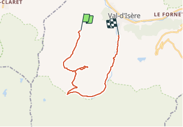
Ruta Senderismo de 12,6 km a descubrir en Auvergne-Rhône-Alpes, Saboya, Val-d'Isère. Esta ruta ha sido propuesta por amiral13.
Descripción
Le départ se fait à partir du Bellevarde, afin de limiter la dénivelée positive. Malheureusement, la descente jusqu'à la combe du santon n'est pas des plus agréable, au milieu de piste en perpétuels travaux. Les plus en forme privilégieront la montée par l'itinéraire de descente au départ du Manchet (près de 1200 m).
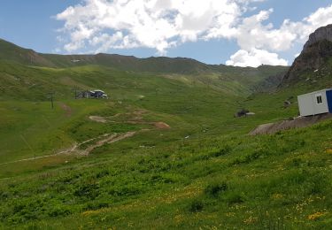
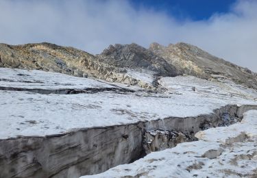
La montée vers l'arrivée du télésiège du grand pré est, elle, un peu plus sympathique. L'itinéraire pour atteindre l'arête du Charvet est évident et emprunte un couloir facile (côté nord). Une fois sur arête la progression demande un peu plus d'attention et traverse en particulier 2 lapiez ; à réserver au randonneurs aguerris ou accompagnés de personnes expérimentées.
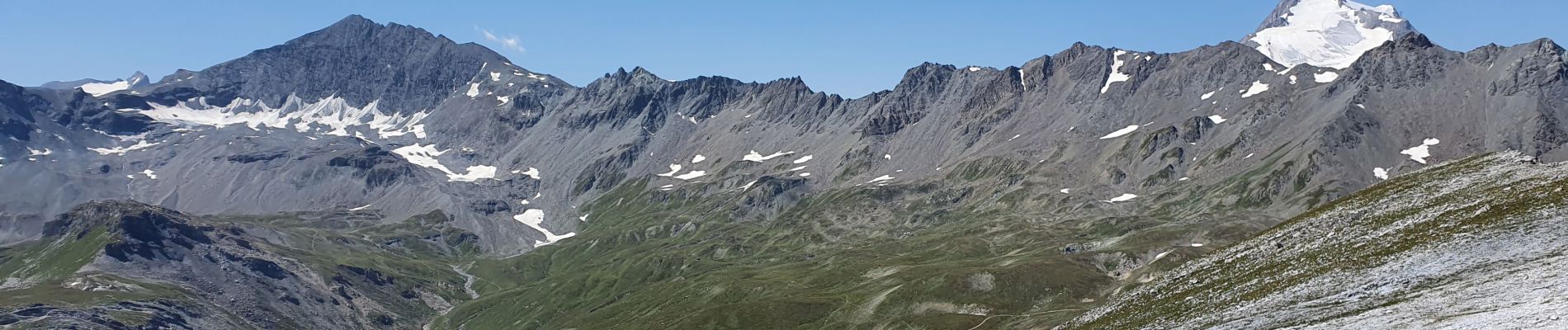
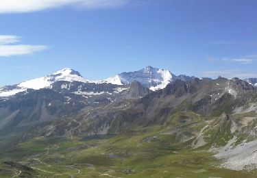
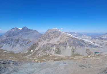
Du sommet, une vue plongeante vertigineuse vers le vallon de la Calabourdane, vous en mettra plein les yeux. Un tour d'horizon vous permettra d'apercevoir les sommets les plus emblématiques de la savoie , ainsi qu'une partie du Massif du mont Blanc plus lointain.
Pour le retour, rebrousser chemin jusqu'au sommet du couloir. 2 choix s'offrent à vous : 1 - Retourner au Bellevarde, le plus cours, mais pas le plus esthétique. 2 - descendre, côté sud dans les prairies, jusqu'à rejoindre un bon chemin. De là il ne reste plus qu'à suivre le ruisseau du Charvet jusqu'au Manchet .
Localización
Comentarios
Excursiones cerca
![Excursión Senderismo Tignes - la pointe de Picheru - Photo](https://media.geolcdn.com/t/375/260/ext.jpg?maxdim=2&url=https%3A%2F%2Fservices.sitytrail.com%2FGeolivesWS%2FDownloadMedia.ashx%3FTrailID%3D813856%26Media%3Dfix__20170820100255.jpg)
![Senderismo Senderismo](https://static1.geolcdn.com/sitytour/trail-icons/101.png)
Senderismo
![](/images/other/stat-length.png)
![](https://static1.geolcdn.com/siteimages/upload/files/16400158638029165_repeat_loop_refresh_sync_direction_icon.png)
![Excursión Senderismo Tignes - l'aiguille perçée - Photo](https://media.geolcdn.com/t/375/260/ext.jpg?maxdim=2&url=https%3A%2F%2Fservices.sitytrail.com%2FGeolivesWS%2FDownloadMedia.ashx%3FTrailID%3D337133%26Media%3Dfix__20140820112508.jpg)
![Senderismo Senderismo](https://static1.geolcdn.com/sitytour/trail-icons/101.png)
Senderismo
![](/images/other/stat-length.png)
![](https://static1.geolcdn.com/siteimages/upload/files/16400158638029165_repeat_loop_refresh_sync_direction_icon.png)
![Excursión Senderismo Tignes - lacs du saut et de la sassiere - Photo](https://media.geolcdn.com/t/375/260/ext.jpg?maxdim=2&url=https%3A%2F%2Fservices.sitytrail.com%2FGeolivesWS%2FDownloadMedia.ashx%3FTrailID%3D336967%26Media%3D637041f5-cff1-4406-a972-10b75ef104dd.JPG)
![Senderismo Senderismo](https://static1.geolcdn.com/sitytour/trail-icons/101.png)
Senderismo
![](/images/other/stat-length.png)
![](https://static1.geolcdn.com/siteimages/upload/files/16400158638029165_repeat_loop_refresh_sync_direction_icon.png)
![Excursión Otra actividad Tignes - Refuge du Palet Col de la Tourne - Photo](https://media.geolcdn.com/t/375/260/ext.jpg?maxdim=2&url=https%3A%2F%2Fservices.sitytrail.com%2FGeolivesWS%2FDownloadMedia.ashx%3FTrailID%3D627243%26Media%3Deac5cf48-a447-4e5f-a31a-610b7e2f4089.jpg)
![Otra actividad Otra actividad](https://static1.geolcdn.com/sitytour/trail-icons/900.png)
Otra actividad
![](/images/other/stat-length.png)
![](https://static1.geolcdn.com/siteimages/upload/files/16400158638029165_repeat_loop_refresh_sync_direction_icon.png)
![Excursión Senderismo Tignes - boucle Tignes le lac - la daille - Photo](https://media.geolcdn.com/t/375/260/ext.jpg?maxdim=2&url=https%3A%2F%2Fservices.sitytrail.com%2FGeolivesWS%2FDownloadMedia.ashx%3FTrailID%3D132978%26Media%3D20120609144529.jpg)
![Senderismo Senderismo](https://static1.geolcdn.com/sitytour/trail-icons/101.png)
Senderismo
![](/images/other/stat-length.png)
![](https://static1.geolcdn.com/siteimages/upload/files/16400158638029165_repeat_loop_refresh_sync_direction_icon.png)
![Excursión Senderismo Val-d'Isère - Les cascades des salins au départ de val d’Isère - Photo](https://media.geolcdn.com/t/375/260/c3b76218-f72c-4eeb-8155-41f32eab8f13.jpg&format=jpg&maxdim=2)
![Senderismo Senderismo](https://static1.geolcdn.com/sitytour/trail-icons/101.png)
Senderismo
![](/images/other/stat-length.png)
![](https://static1.geolcdn.com/siteimages/upload/files/16400158638029165_repeat_loop_refresh_sync_direction_icon.png)
![Excursión Bici de montaña Tignes - tignes vtt - Photo](https://media.geolcdn.com/t/375/260/02d82797-5fef-4551-8767-90094de8a6ba.jpg&format=jpg&maxdim=2)
![Bici de montaña Bici de montaña](https://static1.geolcdn.com/sitytour/trail-icons/202.png)
Bici de montaña
![](/images/other/stat-length.png)
![](https://static1.geolcdn.com/siteimages/upload/files/16400158638029165_repeat_loop_refresh_sync_direction_icon.png)
![Excursión Senderismo Tignes - approche glacière de la cime de la Golette - Photo](https://media.geolcdn.com/t/375/260/72e50cb0-5647-449b-b1a2-a84fe5e68f8a.jpg&format=jpg&maxdim=2)
![Senderismo Senderismo](https://static1.geolcdn.com/sitytour/trail-icons/101.png)
Senderismo
![](/images/other/stat-length.png)
![](https://static1.geolcdn.com/siteimages/upload/files/16400158638029165_repeat_loop_refresh_sync_direction_icon.png)
![Excursión Senderismo Val-d'Isère - pointe de la Sana - Photo](https://media.geolcdn.com/t/375/260/cf1c2ddd-8e22-4533-8c04-6fcf89140ded.jpg&format=jpg&maxdim=2)
![Senderismo Senderismo](https://static1.geolcdn.com/sitytour/trail-icons/101.png)
Senderismo
![](/images/other/stat-length.png)
![](https://static1.geolcdn.com/siteimages/upload/files/16400158638029165_repeat_loop_refresh_sync_direction_icon.png)
Magnifiques photos :)