![](/images/other/stat-length.png)
210530-PC11-circuit-de-creyssens-LE-BOULVE
alain2306
Usuario
![Longitud](/images/other/stat-length.png)
Longitud
7,2 km
![Altitud máxima](https://static1.geolcdn.com/siteimages/upload/files/1508320355ic_sort_altitude_max_24dp.png)
Altitud máxima
274 m
![Desnivel positivo](https://static1.geolcdn.com/siteimages/upload/files/1508320355ic_sort_den_pos_24dp.png)
Desnivel positivo
177 m
![Km-Effort](/images/other/stat-length.png)
Km-Effort
9,5 km
![Altitud mínima](https://static1.geolcdn.com/siteimages/upload/files/1508320355ic_sort_altitude_min_24dp.png)
Altitud mínima
149 m
![Desnivel negativo](https://static1.geolcdn.com/siteimages/upload/files/1508320355ic_sort_den_neg_24dp.png)
Desnivel negativo
178 m
![Boucle](https://static1.geolcdn.com/siteimages/upload/files/16400158638029165_repeat_loop_refresh_sync_direction_icon.png)
Boucle
Sí
Fecha de creación :
2021-08-15 08:26:27.678
Última modificación :
2021-08-16 07:27:39.219
![Senderismo](https://static1.geolcdn.com/sitytour/trail-icons/101.png)
2h09
Dificultad : Medio
![Escanee este código QR para abrir la excursión en la aplicación SityTrail](https://capi.geolives.com/qq0zvz2zws4bq2lad0pu/sitytour/trails/2898683/qr.png?size=200)
Aplicación GPS de excursión GRATIS
A propósito
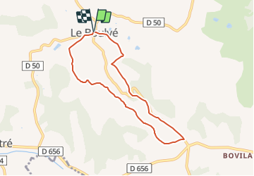
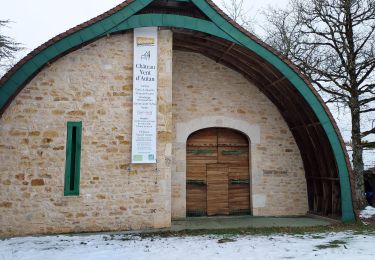
Ruta Senderismo de 7,2 km a descubrir en Occitania, Lot, Porte-du-Quercy. Esta ruta ha sido propuesta por alain2306.
Descripción
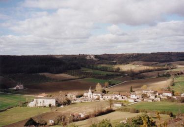
Départ au coeur d’une vallée fertile, le circuit vous offrira un
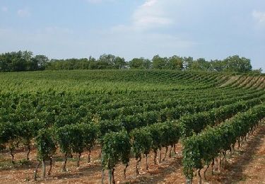
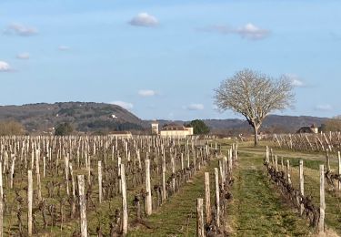
étonnant contraste de couleurs - entre terres
rouges et calcaires du Quercy Blanc -, puis une vue remarquable sur un large panorama.
Localización
País:
France
Región :
Occitania
Departamento/provincia :
Lot
Municipio :
Porte-du-Quercy
Localidad:
Unknown
Salida:(Dec)
Salida:(UTM)
352491 ; 4920183 (31T) N.
Comentarios
Excursiones cerca
![Excursión Bici de montaña Sérignac - De Sérignac à Bonnemaison - Photo](https://media.geolcdn.com/t/375/260/ext.jpg?maxdim=2&url=https%3A%2F%2Fservices.sitytrail.com%2FGeolivesWS%2FDownloadMedia.ashx%3FTrailID%3D316827%26Media%3D15886_4.jpg)
![Bici de montaña Bici de montaña](https://static1.geolcdn.com/sitytour/trail-icons/202.png)
De Sérignac à Bonnemaison
Bici de montaña
Difícil
Sérignac,
Occitania,
Lot,
France
![](/images/other/stat-length.png)
36 km | 45 km-effort
2h 45min
![](https://static1.geolcdn.com/siteimages/upload/files/16400158638029165_repeat_loop_refresh_sync_direction_icon.png)
Sí
![Excursión Senderismo Bélaye - Belaye Grezel - Photo](https://media.geolcdn.com/t/375/260/f77fdfa9-e4aa-4790-b2b0-99369accdf19.jpg&format=jpg&maxdim=2)
![Senderismo Senderismo](https://static1.geolcdn.com/sitytour/trail-icons/101.png)
Belaye Grezel
Senderismo
Muy fácil
Bélaye,
Occitania,
Lot,
France
![](/images/other/stat-length.png)
13,9 km | 17,1 km-effort
2h 56min
![](https://static1.geolcdn.com/siteimages/upload/files/16400158638029165_repeat_loop_refresh_sync_direction_icon.png)
Sí
![Excursión Bici de montaña Porte-du-Quercy - Boucle VTT de Bovila à Bagat en Quercy - Saint Matré - Photo](https://media.geolcdn.com/t/375/260/ext.jpg?maxdim=2&url=https%3A%2F%2Fservices.sitytrail.com%2FGeolivesWS%2FDownloadMedia.ashx%3FTrailID%3D191479%26Media%3D15072_2.jpg)
![Bici de montaña Bici de montaña](https://static1.geolcdn.com/sitytour/trail-icons/202.png)
Boucle VTT de Bovila à Bagat en Quercy - Saint Matré
Bici de montaña
Difícil
Porte-du-Quercy,
Occitania,
Lot,
France
![](/images/other/stat-length.png)
35 km | 42 km-effort
2h 30min
![](https://static1.geolcdn.com/siteimages/upload/files/16400158638029165_repeat_loop_refresh_sync_direction_icon.png)
Sí
![Excursión Senderismo Porte-du-Quercy - boulve 1 - Photo](https://media.geolcdn.com/t/375/260/ext.jpg?maxdim=2&url=https%3A%2F%2Fstatic1.geolcdn.com%2Fsiteimages%2Fupload%2Ffiles%2F1553511878bg_sport_marche.png)
![Senderismo Senderismo](https://static1.geolcdn.com/sitytour/trail-icons/101.png)
boulve 1
Senderismo
Difícil
Porte-du-Quercy,
Occitania,
Lot,
France
![](/images/other/stat-length.png)
11,8 km | 15,9 km-effort
3h 5min
![](https://static1.geolcdn.com/siteimages/upload/files/16400158638029165_repeat_loop_refresh_sync_direction_icon.png)
Sí
![Excursión Senderismo Porte-du-Quercy - Saint Matre - Photo](https://media.geolcdn.com/t/375/260/abbcfd40-2f7b-4488-8edf-a7786d8192a4.jpg&format=jpg&maxdim=2)
![Senderismo Senderismo](https://static1.geolcdn.com/sitytour/trail-icons/101.png)
Saint Matre
Senderismo
Fácil
Porte-du-Quercy,
Occitania,
Lot,
France
![](/images/other/stat-length.png)
5,2 km | 6 km-effort
1h 40min
![](https://static1.geolcdn.com/siteimages/upload/files/16400158638029165_repeat_loop_refresh_sync_direction_icon.png)
Sí
![Excursión Senderismo Bélaye - Belaye - Photo](https://media.geolcdn.com/t/375/260/ext.jpg?maxdim=2&url=https%3A%2F%2Fstatic1.geolcdn.com%2Fsiteimages%2Fupload%2Ffiles%2F1553511878bg_sport_marche.png)
![Senderismo Senderismo](https://static1.geolcdn.com/sitytour/trail-icons/101.png)
![Excursión sport Floressas - Floressas belaye grezel - Photo](https://media.geolcdn.com/t/375/260/ext.jpg?maxdim=2&url=https%3A%2F%2Fsecurestorage.geolives.com%2Fsitytour%2Ftrail-bg%2Fdefault.jpg)
Floressas belaye grezel
sport
Muy fácil
Floressas,
Occitania,
Lot,
France
![](/images/other/stat-length.png)
23 km | 30 km-effort
Desconocido
![](https://static1.geolcdn.com/siteimages/upload/files/16400158638029165_repeat_loop_refresh_sync_direction_icon.png)
Sí
![Excursión Paseo ecuestre Porte-du-Quercy - Etape 4 - Le Boulve / Saint Cyprien - Photo](https://media.geolcdn.com/t/375/260/ext.jpg?maxdim=2&url=https%3A%2F%2Fstatic1.geolcdn.com%2Fsiteimages%2Fupload%2Ffiles%2F1524743154cheval.jpg)
![Paseo ecuestre Paseo ecuestre](https://static1.geolcdn.com/sitytour/trail-icons/301.png)
Etape 4 - Le Boulve / Saint Cyprien
Paseo ecuestre
Medio
Porte-du-Quercy,
Occitania,
Lot,
France
![](/images/other/stat-length.png)
24 km | 30 km-effort
3h 59min
![](https://static1.geolcdn.com/siteimages/upload/files/16400158638029165_repeat_loop_refresh_sync_direction_icon.png)
No
![Excursión Senderismo Porte-du-Quercy - Petits ruisseaux et Grandes Vignes - Photo](https://media.geolcdn.com/t/375/260/ext.jpg?maxdim=2&url=https%3A%2F%2Fstatic1.geolcdn.com%2Fsiteimages%2Fupload%2Ffiles%2F1553511878bg_sport_marche.png)
![Senderismo Senderismo](https://static1.geolcdn.com/sitytour/trail-icons/101.png)
Petits ruisseaux et Grandes Vignes
Senderismo
Difícil
Porte-du-Quercy,
Occitania,
Lot,
France
![](/images/other/stat-length.png)
11,2 km | 13,7 km-effort
3h 6min
![](https://static1.geolcdn.com/siteimages/upload/files/16400158638029165_repeat_loop_refresh_sync_direction_icon.png)
Sí
entre hauteurs avec panoramas et chemin ombragé rando à fzire toute l'année.