![](/images/other/stat-length.png)
![Excursión Senderismo Bouvante - La tête de la Dame - Photo](https://media.geolcdn.com/t/1900/400/0e7685fd-fd5d-401d-81a3-9aec1763e4a7.jpg&format=pjpeg&maxdim=2)
La tête de la Dame
crocau
Usuario
![Longitud](/images/other/stat-length.png)
Longitud
10,4 km
![Altitud máxima](https://static1.geolcdn.com/siteimages/upload/files/1508320355ic_sort_altitude_max_24dp.png)
Altitud máxima
1501 m
![Desnivel positivo](https://static1.geolcdn.com/siteimages/upload/files/1508320355ic_sort_den_pos_24dp.png)
Desnivel positivo
345 m
![Km-Effort](/images/other/stat-length.png)
Km-Effort
15 km
![Altitud mínima](https://static1.geolcdn.com/siteimages/upload/files/1508320355ic_sort_altitude_min_24dp.png)
Altitud mínima
1271 m
![Desnivel negativo](https://static1.geolcdn.com/siteimages/upload/files/1508320355ic_sort_den_neg_24dp.png)
Desnivel negativo
347 m
![Boucle](https://static1.geolcdn.com/siteimages/upload/files/16400158638029165_repeat_loop_refresh_sync_direction_icon.png)
Boucle
Sí
Fecha de creación :
2021-08-12 03:58:59.852
Última modificación :
2021-08-17 16:20:48.088
![Senderismo](https://static1.geolcdn.com/sitytour/trail-icons/101.png)
3h09
Dificultad : Fácil
![Escanee este código QR para abrir la excursión en la aplicación SityTrail](https://capi.geolives.com/qq0zvz2zws4bq2lad0pu/sitytour/trails/2895090/qr.png?size=200)
Aplicación GPS de excursión GRATIS
A propósito
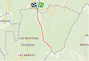
Ruta Senderismo de 10,4 km a descubrir en Auvergne-Rhône-Alpes, Drôme, Bouvante. Esta ruta ha sido propuesta por crocau.
Descripción
Rando assez facile. Le début est plat et long avant d'atteindre la verdure. Ensuite le chemin est ultra simple avec une légère montée à la fin.
Localización
País:
France
Región :
Auvergne-Rhône-Alpes
Departamento/provincia :
Drôme
Municipio :
Bouvante
Localidad:
Unknown
Salida:(Dec)
Salida:(UTM)
676378 ; 4974018 (31T) N.
Comentarios
Excursiones cerca
![Excursión Senderismo Omblèze - 2021-07-26_17h20m33_1627312809705_Plateau d_Ambel 15km.gpx.xml - Photo](https://media.geolcdn.com/t/375/260/07e91571-7633-48aa-a91e-19fa46a2d0cc.jpg&format=jpg&maxdim=2)
![Senderismo Senderismo](https://static1.geolcdn.com/sitytour/trail-icons/101.png)
2021-07-26_17h20m33_1627312809705_Plateau d_Ambel 15km.gpx.xml
Senderismo
Muy difícil
(1)
Omblèze,
Auvergne-Rhône-Alpes,
Drôme,
France
![](/images/other/stat-length.png)
14,9 km | 22 km-effort
4h 56min
![](https://static1.geolcdn.com/siteimages/upload/files/16400158638029165_repeat_loop_refresh_sync_direction_icon.png)
Sí
![Excursión Senderismo Bouvante - 01 - Photo](https://media.geolcdn.com/t/375/260/ext.jpg?maxdim=2&url=https%3A%2F%2Fservices.sitytrail.com%2FGeolivesWS%2FDownloadMedia.ashx%3FTrailID%3D835352%26Media%3Dfix__20170924162337.jpg)
![Senderismo Senderismo](https://static1.geolcdn.com/sitytour/trail-icons/101.png)
01
Senderismo
Medio
(1)
Bouvante,
Auvergne-Rhône-Alpes,
Drôme,
France
![](/images/other/stat-length.png)
12,5 km | 19,5 km-effort
5h 7min
![](https://static1.geolcdn.com/siteimages/upload/files/16400158638029165_repeat_loop_refresh_sync_direction_icon.png)
Sí
![Excursión Senderismo Le Chaffal - 26 vacherie arches comberoufle - Photo](https://media.geolcdn.com/t/375/260/27ca79a9-2463-4a38-9d47-59fa4758352c.jpg&format=jpg&maxdim=2)
![Senderismo Senderismo](https://static1.geolcdn.com/sitytour/trail-icons/101.png)
26 vacherie arches comberoufle
Senderismo
Fácil
Le Chaffal,
Auvergne-Rhône-Alpes,
Drôme,
France
![](/images/other/stat-length.png)
7,3 km | 12,1 km-effort
3h 25min
![](https://static1.geolcdn.com/siteimages/upload/files/16400158638029165_repeat_loop_refresh_sync_direction_icon.png)
Sí
![Excursión Senderismo Bouvante - 26 bouvante pas ligue st truite - Photo](https://media.geolcdn.com/t/375/260/9494233e-7248-475d-add1-20018e6bbb97.jpg&format=jpg&maxdim=2)
![Senderismo Senderismo](https://static1.geolcdn.com/sitytour/trail-icons/101.png)
26 bouvante pas ligue st truite
Senderismo
Difícil
Bouvante,
Auvergne-Rhône-Alpes,
Drôme,
France
![](/images/other/stat-length.png)
18,7 km | 31 km-effort
8h 42min
![](https://static1.geolcdn.com/siteimages/upload/files/16400158638029165_repeat_loop_refresh_sync_direction_icon.png)
No
![Excursión Senderismo Omblèze - 26 pas de la sausse - Photo](https://media.geolcdn.com/t/375/260/ext.jpg?maxdim=2&url=https%3A%2F%2Fservices.sitytrail.com%2FGeolivesWS%2FDownloadMedia.ashx%3FTrailID%3D472646%26Media%3Dfix__20140403141012.jpg)
![Senderismo Senderismo](https://static1.geolcdn.com/sitytour/trail-icons/101.png)
26 pas de la sausse
Senderismo
Medio
Omblèze,
Auvergne-Rhône-Alpes,
Drôme,
France
![](/images/other/stat-length.png)
12,2 km | 22 km-effort
4h 56min
![](https://static1.geolcdn.com/siteimages/upload/files/16400158638029165_repeat_loop_refresh_sync_direction_icon.png)
No
![Excursión Senderismo Léoncel - Pierre Chauve depuis le Col de Tourniol - Photo](https://media.geolcdn.com/t/375/260/ext.jpg?maxdim=2&url=https%3A%2F%2Fstatic1.geolcdn.com%2Fsiteimages%2Fupload%2Ffiles%2F1553511878bg_sport_marche.png)
![Senderismo Senderismo](https://static1.geolcdn.com/sitytour/trail-icons/101.png)
Pierre Chauve depuis le Col de Tourniol
Senderismo
Fácil
(3)
Léoncel,
Auvergne-Rhône-Alpes,
Drôme,
France
![](/images/other/stat-length.png)
7,9 km | 12,3 km-effort
2h 52min
![](https://static1.geolcdn.com/siteimages/upload/files/16400158638029165_repeat_loop_refresh_sync_direction_icon.png)
Sí
![Excursión Bici de montaña Léoncel - Tête de la Dame - Photo](https://media.geolcdn.com/t/375/260/ext.jpg?maxdim=2&url=https%3A%2F%2Fstatic1.geolcdn.com%2Fsiteimages%2Fupload%2Ffiles%2F1524743154velo.jpg)
![Bici de montaña Bici de montaña](https://static1.geolcdn.com/sitytour/trail-icons/202.png)
Tête de la Dame
Bici de montaña
Medio
(1)
Léoncel,
Auvergne-Rhône-Alpes,
Drôme,
France
![](/images/other/stat-length.png)
27 km | 39 km-effort
2h 35min
![](https://static1.geolcdn.com/siteimages/upload/files/16400158638029165_repeat_loop_refresh_sync_direction_icon.png)
Sí
![Excursión Senderismo Le Chaffal - Col de la Bataille, Omblèze - Photo](https://media.geolcdn.com/t/375/260/23572a18-c053-46ab-b650-7388c57687af.jpg&format=jpg&maxdim=2)
![Senderismo Senderismo](https://static1.geolcdn.com/sitytour/trail-icons/101.png)
Col de la Bataille, Omblèze
Senderismo
Difícil
Le Chaffal,
Auvergne-Rhône-Alpes,
Drôme,
France
![](/images/other/stat-length.png)
17,6 km | 32 km-effort
5h 15min
![](https://static1.geolcdn.com/siteimages/upload/files/16400158638029165_repeat_loop_refresh_sync_direction_icon.png)
Sí
![Excursión Senderismo Le Chaffal - les arches de Combleroufle - Photo](https://media.geolcdn.com/t/375/260/d3d11a7f-607e-4366-bcda-e95ee5b96279.jpg&format=jpg&maxdim=2)
![Senderismo Senderismo](https://static1.geolcdn.com/sitytour/trail-icons/101.png)
les arches de Combleroufle
Senderismo
Medio
Le Chaffal,
Auvergne-Rhône-Alpes,
Drôme,
France
![](/images/other/stat-length.png)
9,6 km | 16,3 km-effort
3h 12min
![](https://static1.geolcdn.com/siteimages/upload/files/16400158638029165_repeat_loop_refresh_sync_direction_icon.png)
Sí