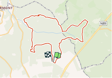
![](/images/other/stat-length.png)
![Excursión Saint-Hubert - 2021-08-09_22h22m11_Cirkwi-Randonnée_incontournable_à_Saint-Hubert_-_Chemins_de_solitude - Photo](https://media.geolcdn.com/t/1900/400/ext.pjpeg?maxdim=2&url=https%3A%2F%2Fsecurestorage.geolives.com%2Fsitytour%2Ftrail-bg%2Fdefault.jpg)
2021-08-09_22h22m11_Cirkwi-Randonnée_incontournable_à_Saint-Hubert_-_Chemins_de_solitude
frederic.lorimier@skynet.be
Usuario
![Longitud](/images/other/stat-length.png)
![Altitud máxima](https://static1.geolcdn.com/siteimages/upload/files/1508320355ic_sort_altitude_max_24dp.png)
![Desnivel positivo](https://static1.geolcdn.com/siteimages/upload/files/1508320355ic_sort_den_pos_24dp.png)
![Km-Effort](/images/other/stat-length.png)
![Altitud mínima](https://static1.geolcdn.com/siteimages/upload/files/1508320355ic_sort_altitude_min_24dp.png)
![Desnivel negativo](https://static1.geolcdn.com/siteimages/upload/files/1508320355ic_sort_den_neg_24dp.png)
![Boucle](https://static1.geolcdn.com/siteimages/upload/files/16400158638029165_repeat_loop_refresh_sync_direction_icon.png)
![Escanee este código QR para abrir la excursión en la aplicación SityTrail](https://capi.geolives.com/qq0zvz2zws4bq2lad0pu/sitytour/trails/2892120/qr.png?size=200)
Aplicación GPS de excursión GRATIS
A propósito
Ruta de 19,8 km a descubrir en Valonia, Luxemburgo, Saint-Hubert. Esta ruta ha sido propuesta por frederic.lorimier@skynet.be.
Descripción
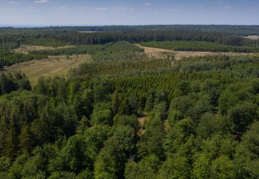
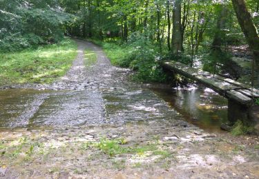
Cette balade vous fait entrer dans l'âme du grand vert. La forêt de Saint-Hubert est un hymne à la vie sauvage. Après avoir quitté la Fagne de la Doneuse, débute une vallée luxuriante où coule un ruisseau. La descente est longue, agrémentée du bruit, toujours envoûtant, du ruisseau dévalant les rochers. Chemin faisant, vous longez la Boulaie du Rouge Poncé, une réserve naturelle qui représente un type de forêt qui recouvrait l’Ardenne avant son assèchement pour la production et l’exploitation de conifères. Plus loin, l’observatoire de la Bilaude permet, avec un peu de chance, d’observer la faune forestière. Via la vallée de la Masblette, l’itinéraire s’enfonce dans le monde du silence … Randonnée issue de la brochure "20 randonnées pédestres incontournables" à consulter et télécharger ici: https://walloniebelgiquetourisme.be/fr-be/3/jaime/activites-sportives/randonnees-et-promenades/brochures-de-randonnees
Localización
Comentarios
Excursiones cerca
![Excursión Senderismo Saint-Hubert - Saint-Hubert - La Borne (SH07) - Photo](https://media.geolcdn.com/t/375/260/ext.jpg?maxdim=2&url=https%3A%2F%2Fservices.sitytrail.com%2FGeolivesWS%2FDownloadMedia.ashx%3FTrailID%3D334588%26Media%3D91d6a6a6-ea9a-437b-8504-44eab9898f8f.JPG)
![Senderismo Senderismo](https://static1.geolcdn.com/sitytour/trail-icons/101.png)
Senderismo
![](/images/other/stat-length.png)
![](https://static1.geolcdn.com/siteimages/upload/files/16400158638029165_repeat_loop_refresh_sync_direction_icon.png)
![Senderismo Senderismo](https://static1.geolcdn.com/sitytour/trail-icons/101.png)
Senderismo
![](/images/other/stat-length.png)
![](https://static1.geolcdn.com/siteimages/upload/files/16400158638029165_repeat_loop_refresh_sync_direction_icon.png)
![Excursión Senderismo Saint-Hubert - Saint-Hubert - Les Abanages (SH03) - Photo](https://media.geolcdn.com/t/375/260/ext.jpg?maxdim=2&url=https%3A%2F%2Fservices.sitytrail.com%2FGeolivesWS%2FDownloadMedia.ashx%3FTrailID%3D334550%26Media%3D8af2823f-59d0-452e-b66b-4a477ca4facd.JPG)
![Senderismo Senderismo](https://static1.geolcdn.com/sitytour/trail-icons/101.png)
Senderismo
![](/images/other/stat-length.png)
![](https://static1.geolcdn.com/siteimages/upload/files/16400158638029165_repeat_loop_refresh_sync_direction_icon.png)
![Excursión Senderismo Saint-Hubert - Saint-Hubert - Les Gottes (SH02) - Photo](https://media.geolcdn.com/t/375/260/ext.jpg?maxdim=2&url=https%3A%2F%2Fservices.sitytrail.com%2FGeolivesWS%2FDownloadMedia.ashx%3FTrailID%3D334532%26Media%3D483dd5de-c3cc-4d3d-acb4-87fceee0aac0.JPG)
![Senderismo Senderismo](https://static1.geolcdn.com/sitytour/trail-icons/101.png)
Senderismo
![](/images/other/stat-length.png)
![](https://static1.geolcdn.com/siteimages/upload/files/16400158638029165_repeat_loop_refresh_sync_direction_icon.png)
![Excursión Senderismo Saint-Hubert - Marche ADEPS Arville - Photo](https://media.geolcdn.com/t/375/260/3bbd3001-2495-4fe0-a9c1-b38774f0038e.jpg&format=jpg&maxdim=2)
![Senderismo Senderismo](https://static1.geolcdn.com/sitytour/trail-icons/101.png)
Senderismo
![](/images/other/stat-length.png)
![](https://static1.geolcdn.com/siteimages/upload/files/16400158638029165_repeat_loop_refresh_sync_direction_icon.png)
![Excursión Senderismo Saint-Hubert - ADEPS Saint Hubert - Photo](https://media.geolcdn.com/t/375/260/018b420c-08b1-4fdb-919c-55acbcd603df.jpg&format=jpg&maxdim=2)
![Senderismo Senderismo](https://static1.geolcdn.com/sitytour/trail-icons/101.png)
Senderismo
![](/images/other/stat-length.png)
![](https://static1.geolcdn.com/siteimages/upload/files/16400158638029165_repeat_loop_refresh_sync_direction_icon.png)
![Senderismo Senderismo](https://static1.geolcdn.com/sitytour/trail-icons/101.png)
Senderismo
![](/images/other/stat-length.png)
![](https://static1.geolcdn.com/siteimages/upload/files/16400158638029165_repeat_loop_refresh_sync_direction_icon.png)
![Senderismo Senderismo](https://static1.geolcdn.com/sitytour/trail-icons/101.png)
Senderismo
![](/images/other/stat-length.png)
![](https://static1.geolcdn.com/siteimages/upload/files/16400158638029165_repeat_loop_refresh_sync_direction_icon.png)
![Senderismo Senderismo](https://static1.geolcdn.com/sitytour/trail-icons/101.png)
Senderismo
![](/images/other/stat-length.png)
![](https://static1.geolcdn.com/siteimages/upload/files/16400158638029165_repeat_loop_refresh_sync_direction_icon.png)