![](/images/other/stat-length.png)
![Excursión Senderismo Les Belleville - sentier des lacs - Photo](https://media.geolcdn.com/t/1900/400/ext.pjpeg?maxdim=2&url=https%3A%2F%2Fstatic1.geolcdn.com%2Fsiteimages%2Fupload%2Ffiles%2F1553511878bg_sport_marche.png)
sentier des lacs
myjackotte
Usuario
![Longitud](/images/other/stat-length.png)
Longitud
18,7 km
![Altitud máxima](https://static1.geolcdn.com/siteimages/upload/files/1508320355ic_sort_altitude_max_24dp.png)
Altitud máxima
2537 m
![Desnivel positivo](https://static1.geolcdn.com/siteimages/upload/files/1508320355ic_sort_den_pos_24dp.png)
Desnivel positivo
1145 m
![Km-Effort](/images/other/stat-length.png)
Km-Effort
34 km
![Altitud mínima](https://static1.geolcdn.com/siteimages/upload/files/1508320355ic_sort_altitude_min_24dp.png)
Altitud mínima
1759 m
![Desnivel negativo](https://static1.geolcdn.com/siteimages/upload/files/1508320355ic_sort_den_neg_24dp.png)
Desnivel negativo
1153 m
![Boucle](https://static1.geolcdn.com/siteimages/upload/files/16400158638029165_repeat_loop_refresh_sync_direction_icon.png)
Boucle
Sí
Fecha de creación :
2021-08-09 08:20:04.359
Última modificación :
2021-08-09 17:08:59.537
![Senderismo](https://static1.geolcdn.com/sitytour/trail-icons/101.png)
7h50
Dificultad : Medio
![Escanee este código QR para abrir la excursión en la aplicación SityTrail](https://capi.geolives.com/qq0zvz2zws4bq2lad0pu/sitytour/trails/2891859/qr.png?size=200)
Aplicación GPS de excursión GRATIS
A propósito
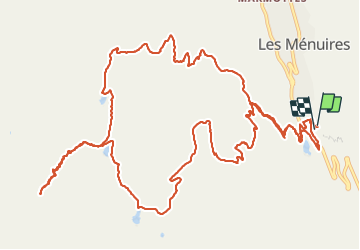
Ruta Senderismo de 18,7 km a descubrir en Auvergne-Rhône-Alpes, Saboya, Les Belleville. Esta ruta ha sido propuesta por myjackotte.
Descripción
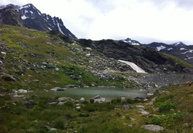
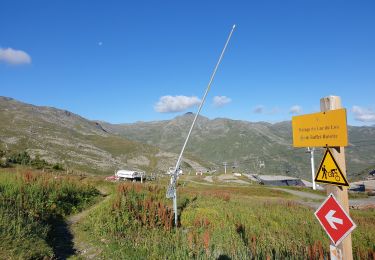
pb de timing à la descente apres le lac noir, il était indiqué 3h45 pour le lac du loup, donc pas le temps pour nous. dommage la vallée est superbe
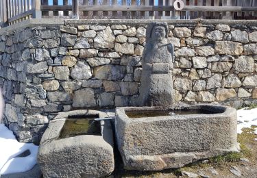
Localización
País:
France
Región :
Auvergne-Rhône-Alpes
Departamento/provincia :
Saboya
Municipio :
Les Belleville
Localidad:
Saint-Martin-de-Belleville
Salida:(Dec)
Salida:(UTM)
307271 ; 5020812 (32T) N.
Comentarios
Excursiones cerca
![Excursión Senderismo Les Belleville - FR - VAL THORENS - Circuit des lacs de Val-Thorens - Photo](https://media.geolcdn.com/t/375/260/ext.jpg?maxdim=2&url=https%3A%2F%2Fservices.sitytrail.com%2FGeolivesWS%2FDownloadMedia.ashx%3FTrailID%3D333495%26Media%3D20140811122637.jpg)
![Senderismo Senderismo](https://static1.geolcdn.com/sitytour/trail-icons/101.png)
FR - VAL THORENS - Circuit des lacs de Val-Thorens
Senderismo
Muy fácil
(1)
Les Belleville,
Auvergne-Rhône-Alpes,
Saboya,
France
![](/images/other/stat-length.png)
6,2 km | 8,6 km-effort
4h 15min
![](https://static1.geolcdn.com/siteimages/upload/files/16400158638029165_repeat_loop_refresh_sync_direction_icon.png)
Sí
![Excursión Senderismo Les Belleville - FR - VAL THORENS - Lac du Montaulever - Photo](https://media.geolcdn.com/t/375/260/ext.jpg?maxdim=2&url=https%3A%2F%2Fservices.sitytrail.com%2FGeolivesWS%2FDownloadMedia.ashx%3FTrailID%3D332855%26Media%3D20140810110245.jpg)
![Senderismo Senderismo](https://static1.geolcdn.com/sitytour/trail-icons/101.png)
FR - VAL THORENS - Lac du Montaulever
Senderismo
Muy fácil
(2)
Les Belleville,
Auvergne-Rhône-Alpes,
Saboya,
France
![](/images/other/stat-length.png)
4,5 km | 8,3 km-effort
2h 9min
![](https://static1.geolcdn.com/siteimages/upload/files/16400158638029165_repeat_loop_refresh_sync_direction_icon.png)
Sí
![Excursión Senderismo Les Belleville - le lou-la masse-les lacs - Photo](https://media.geolcdn.com/t/375/260/ext.jpg?maxdim=2&url=https%3A%2F%2Fservices.sitytrail.com%2FGeolivesWS%2FDownloadMedia.ashx%3FTrailID%3D601214%26Media%3D20160720162358.jpg)
![Senderismo Senderismo](https://static1.geolcdn.com/sitytour/trail-icons/101.png)
le lou-la masse-les lacs
Senderismo
Muy difícil
(1)
Les Belleville,
Auvergne-Rhône-Alpes,
Saboya,
France
![](/images/other/stat-length.png)
23 km | 43 km-effort
7h 2min
![](https://static1.geolcdn.com/siteimages/upload/files/16400158638029165_repeat_loop_refresh_sync_direction_icon.png)
No
![Excursión Senderismo Les Belleville - Le sentier des Choumes ( N °9) - Photo](https://media.geolcdn.com/t/375/260/5cb3a0b1-6ffc-4a97-954a-79c4931bc02f.jpg&format=jpg&maxdim=2)
![Senderismo Senderismo](https://static1.geolcdn.com/sitytour/trail-icons/101.png)
Le sentier des Choumes ( N °9)
Senderismo
Fácil
Les Belleville,
Auvergne-Rhône-Alpes,
Saboya,
France
![](/images/other/stat-length.png)
6,7 km | 8,8 km-effort
1h 36min
![](https://static1.geolcdn.com/siteimages/upload/files/16400158638029165_repeat_loop_refresh_sync_direction_icon.png)
No
![Excursión Senderismo Les Belleville - N°1 - La découverte des village au fil du Doron - Photo](https://media.geolcdn.com/t/375/260/15306859-1875-4a25-b739-668d92dd6d6e.jpg&format=jpg&maxdim=2)
![Senderismo Senderismo](https://static1.geolcdn.com/sitytour/trail-icons/101.png)
N°1 - La découverte des village au fil du Doron
Senderismo
Fácil
Les Belleville,
Auvergne-Rhône-Alpes,
Saboya,
France
![](/images/other/stat-length.png)
9,4 km | 12,4 km-effort
1h 54min
![](https://static1.geolcdn.com/siteimages/upload/files/16400158638029165_repeat_loop_refresh_sync_direction_icon.png)
No
![Excursión Senderismo Les Belleville - Le sentier Giraud - N° 8 - Photo](https://media.geolcdn.com/t/375/260/f9a4a370-f6ae-440a-97ef-2e1286f7b148.jpg&format=jpg&maxdim=2)
![Senderismo Senderismo](https://static1.geolcdn.com/sitytour/trail-icons/101.png)
Le sentier Giraud - N° 8
Senderismo
Fácil
Les Belleville,
Auvergne-Rhône-Alpes,
Saboya,
France
![](/images/other/stat-length.png)
5 km | 6,5 km-effort
1h 9min
![](https://static1.geolcdn.com/siteimages/upload/files/16400158638029165_repeat_loop_refresh_sync_direction_icon.png)
No
![Excursión Senderismo Les Belleville - La Croisette - Le Plan d'eau des Bruyères - Photo](https://media.geolcdn.com/t/375/260/debed00d-5703-4a8c-a041-854ec81465b6.jpg&format=jpg&maxdim=2)
![Senderismo Senderismo](https://static1.geolcdn.com/sitytour/trail-icons/101.png)
La Croisette - Le Plan d'eau des Bruyères
Senderismo
Fácil
Les Belleville,
Auvergne-Rhône-Alpes,
Saboya,
France
![](/images/other/stat-length.png)
7,7 km | 10,5 km-effort
1h 53min
![](https://static1.geolcdn.com/siteimages/upload/files/16400158638029165_repeat_loop_refresh_sync_direction_icon.png)
Sí
![Excursión Senderismo Les Belleville - Lac du Lou - Photo](https://media.geolcdn.com/t/375/260/2753a11b-3e3e-4ec9-8c50-abd7984db138.jpg&format=jpg&maxdim=2)
![Senderismo Senderismo](https://static1.geolcdn.com/sitytour/trail-icons/101.png)
Lac du Lou
Senderismo
Medio
Les Belleville,
Auvergne-Rhône-Alpes,
Saboya,
France
![](/images/other/stat-length.png)
11,3 km | 15,5 km-effort
4h 38min
![](https://static1.geolcdn.com/siteimages/upload/files/16400158638029165_repeat_loop_refresh_sync_direction_icon.png)
Sí
![Excursión Senderismo Les Belleville - descente point de la masse - Photo](https://media.geolcdn.com/t/375/260/ext.jpg?maxdim=2&url=https%3A%2F%2Fstatic1.geolcdn.com%2Fsiteimages%2Fupload%2Ffiles%2F1553511878bg_sport_marche.png)
![Senderismo Senderismo](https://static1.geolcdn.com/sitytour/trail-icons/101.png)
descente point de la masse
Senderismo
Medio
(1)
Les Belleville,
Auvergne-Rhône-Alpes,
Saboya,
France
![](/images/other/stat-length.png)
9,3 km | 13,3 km-effort
3h 30min
![](https://static1.geolcdn.com/siteimages/upload/files/16400158638029165_repeat_loop_refresh_sync_direction_icon.png)
No