![](/images/other/stat-length.png)
![Excursión Senderismo La Salle-les-Alpes - 2021-08-07_08h55m47_la-cime-de-puy-la-salle - Photo](https://media.geolcdn.com/t/1900/400/ext.pjpeg?maxdim=2&url=https%3A%2F%2Fstatic1.geolcdn.com%2Fsiteimages%2Fupload%2Ffiles%2F1553511878bg_sport_marche.png)
2021-08-07_08h55m47_la-cime-de-puy-la-salle
jpb83
Usuario
![Longitud](/images/other/stat-length.png)
![Altitud máxima](https://static1.geolcdn.com/siteimages/upload/files/1508320355ic_sort_altitude_max_24dp.png)
![Desnivel positivo](https://static1.geolcdn.com/siteimages/upload/files/1508320355ic_sort_den_pos_24dp.png)
![Km-Effort](/images/other/stat-length.png)
![Altitud mínima](https://static1.geolcdn.com/siteimages/upload/files/1508320355ic_sort_altitude_min_24dp.png)
![Desnivel negativo](https://static1.geolcdn.com/siteimages/upload/files/1508320355ic_sort_den_neg_24dp.png)
![Boucle](https://static1.geolcdn.com/siteimages/upload/files/16400158638029165_repeat_loop_refresh_sync_direction_icon.png)
![Senderismo](https://static1.geolcdn.com/sitytour/trail-icons/101.png)
3h12
Dificultad : Difícil
![Escanee este código QR para abrir la excursión en la aplicación SityTrail](https://capi.geolives.com/qq0zvz2zws4bq2lad0pu/sitytour/trails/2888265/qr.png?size=200)
Aplicación GPS de excursión GRATIS
A propósito
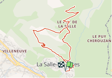
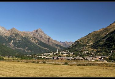
Ruta Senderismo de 7 km a descubrir en Provenza-Alpes-Costa Azul, Altos Alpes, La Salle-les-Alpes. Esta ruta ha sido propuesta por jpb83.
Descripción
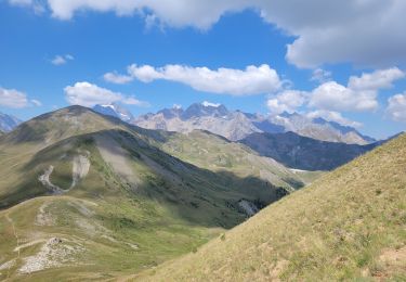
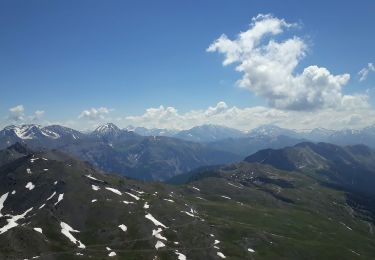
Promenade courte à proximité de Villeneuve, beau point de vue sur le massif et le domaine d'altitude.
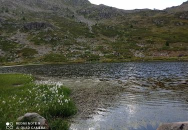
Sur le versant sud, cette promenade chemine progressivement le long du Torrent de la Salle.
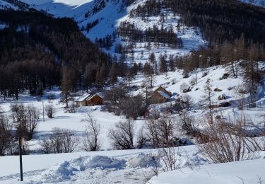
Départ / Arrivée : Entrée du village de la Salle - Coté Sud
Emprunter le chemin carrossable qui s'élève juste avant le pont, à l'entrée sud du village de La Salle.
Monter en direction des maisons de "Rivo".
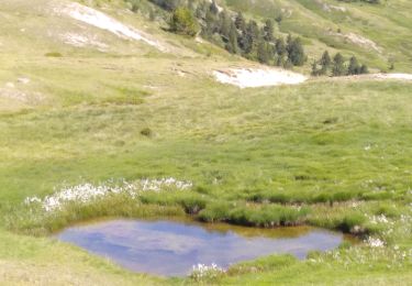
1- Après avoir traverser le torrent continuer avant de bifurquer à droite en direction des Tures.
Aux chalets des Thures tenir le sentier à droite et continuer la progression jusqu'aux chalets d'alpage de Puy la Salle (1880 m).
Gagner ensuite la Cime de Puy la Salle, 100 mètres plus haut (1980 m).
2 - Pour le retour, emprunter le sentier qui redescend vers "le Piré" puis revenir par une autre route de terre qui revient au village de la Salle.
Localización
Comentarios
Excursiones cerca
![Excursión Senderismo Saint-Chaffrey - le Prorel au départ de la Serre Chevalier - Photo](https://media.geolcdn.com/t/375/260/8fe43045-679c-4525-8bd4-b81d7f3d7490.jpg&format=jpg&maxdim=2)
![Senderismo Senderismo](https://static1.geolcdn.com/sitytour/trail-icons/101.png)
Senderismo
![](/images/other/stat-length.png)
![](https://static1.geolcdn.com/siteimages/upload/files/16400158638029165_repeat_loop_refresh_sync_direction_icon.png)
![Excursión Senderismo La Salle-les-Alpes - le grand Aréa (boucle) - Photo](https://media.geolcdn.com/t/375/260/2c5e44d9-ecb7-452d-bd8a-94765088c19f.jpg&format=jpg&maxdim=2)
![Senderismo Senderismo](https://static1.geolcdn.com/sitytour/trail-icons/101.png)
Senderismo
![](/images/other/stat-length.png)
![](https://static1.geolcdn.com/siteimages/upload/files/16400158638029165_repeat_loop_refresh_sync_direction_icon.png)
![Excursión Senderismo La Salle-les-Alpes - Grand AREA 21/06/18 - Photo](https://media.geolcdn.com/t/375/260/86fd0548-34c0-4cb0-a2ba-6eed03b231af.jpg&format=jpg&maxdim=2)
![Senderismo Senderismo](https://static1.geolcdn.com/sitytour/trail-icons/101.png)
Senderismo
![](/images/other/stat-length.png)
![](https://static1.geolcdn.com/siteimages/upload/files/16400158638029165_repeat_loop_refresh_sync_direction_icon.png)
![Excursión Senderismo Saint-Chaffrey - Chantemerle-la Salle les Aples 13-08-2018 - Photo](https://media.geolcdn.com/t/375/260/ext.jpg?maxdim=2&url=https%3A%2F%2Fstatic1.geolcdn.com%2Fsiteimages%2Fupload%2Ffiles%2F1553511878bg_sport_marche.png)
![Senderismo Senderismo](https://static1.geolcdn.com/sitytour/trail-icons/101.png)
Senderismo
![](/images/other/stat-length.png)
![](https://static1.geolcdn.com/siteimages/upload/files/16400158638029165_repeat_loop_refresh_sync_direction_icon.png)
![Excursión Bici de montaña Saint-Chaffrey - granons tronchet - Photo](https://media.geolcdn.com/t/375/260/ext.jpg?maxdim=2&url=https%3A%2F%2Fstatic1.geolcdn.com%2Fsiteimages%2Fupload%2Ffiles%2F1524743154velo.jpg)
![Bici de montaña Bici de montaña](https://static1.geolcdn.com/sitytour/trail-icons/202.png)
Bici de montaña
![](/images/other/stat-length.png)
![](https://static1.geolcdn.com/siteimages/upload/files/16400158638029165_repeat_loop_refresh_sync_direction_icon.png)
![Excursión Senderismo Saint-Chaffrey - 05 lacs de l'oule,christol,rond 25/08/24 - Photo](https://media.geolcdn.com/t/375/260/8fa64624-96b2-461e-80f5-25df14bfce59.jpg&format=jpg&maxdim=2)
![Senderismo Senderismo](https://static1.geolcdn.com/sitytour/trail-icons/101.png)
Senderismo
![](/images/other/stat-length.png)
![](https://static1.geolcdn.com/siteimages/upload/files/16400158638029165_repeat_loop_refresh_sync_direction_icon.png)
![Excursión Senderismo Le Monêtier-les-Bains - Les Boussardes - Photo](https://media.geolcdn.com/t/375/260/404ff157-d268-4b88-bced-a12b6573121a.jpg&format=jpg&maxdim=2)
![Senderismo Senderismo](https://static1.geolcdn.com/sitytour/trail-icons/101.png)
Senderismo
![](/images/other/stat-length.png)
![](https://static1.geolcdn.com/siteimages/upload/files/16400158638029165_repeat_loop_refresh_sync_direction_icon.png)
![Excursión Senderismo Saint-Chaffrey - col du granon-croix de la cime - Photo](https://media.geolcdn.com/t/375/260/7bf366d1-6261-4976-a3ad-d0b07d26ff8c.jpg&format=jpg&maxdim=2)
![Senderismo Senderismo](https://static1.geolcdn.com/sitytour/trail-icons/101.png)
Senderismo
![](/images/other/stat-length.png)
![](https://static1.geolcdn.com/siteimages/upload/files/16400158638029165_repeat_loop_refresh_sync_direction_icon.png)
![Excursión Senderismo Le Monêtier-les-Bains - Grand Aréa - Photo](https://media.geolcdn.com/t/375/260/183c96a2-203b-45f5-bf34-18c8407695c1.jpg&format=jpg&maxdim=2)
![Senderismo Senderismo](https://static1.geolcdn.com/sitytour/trail-icons/101.png)
Senderismo
![](/images/other/stat-length.png)
![](https://static1.geolcdn.com/siteimages/upload/files/16400158638029165_repeat_loop_refresh_sync_direction_icon.png)