![](/images/other/stat-length.png)
![Excursión Senderismo Doucy-en-Bauges - Doucy Mont Trelod - Photo](https://media.geolcdn.com/t/1900/400/3c88a5b7-204b-4d06-a366-20b88cf73f54.jpg&format=pjpeg&maxdim=2)
Doucy Mont Trelod
dchauprade
Usuario
![Longitud](/images/other/stat-length.png)
Longitud
15,4 km
![Altitud máxima](https://static1.geolcdn.com/siteimages/upload/files/1508320355ic_sort_altitude_max_24dp.png)
Altitud máxima
2164 m
![Desnivel positivo](https://static1.geolcdn.com/siteimages/upload/files/1508320355ic_sort_den_pos_24dp.png)
Desnivel positivo
1273 m
![Km-Effort](/images/other/stat-length.png)
Km-Effort
32 km
![Altitud mínima](https://static1.geolcdn.com/siteimages/upload/files/1508320355ic_sort_altitude_min_24dp.png)
Altitud mínima
1125 m
![Desnivel negativo](https://static1.geolcdn.com/siteimages/upload/files/1508320355ic_sort_den_neg_24dp.png)
Desnivel negativo
1268 m
![Boucle](https://static1.geolcdn.com/siteimages/upload/files/16400158638029165_repeat_loop_refresh_sync_direction_icon.png)
Boucle
Sí
Fecha de creación :
2021-08-06 08:29:52.0
Última modificación :
2021-08-06 20:48:40.249
![Senderismo](https://static1.geolcdn.com/sitytour/trail-icons/101.png)
6h56
Dificultad : Difícil
![Escanee este código QR para abrir la excursión en la aplicación SityTrail](https://capi.geolives.com/qq0zvz2zws4bq2lad0pu/sitytour/trails/2888137/qr.png?size=200)
Aplicación GPS de excursión GRATIS
A propósito
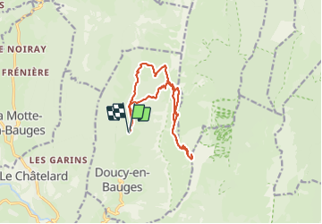
Ruta Senderismo de 15,4 km a descubrir en Auvergne-Rhône-Alpes, Saboya, Doucy-en-Bauges. Esta ruta ha sido propuesta por dchauprade.
Descripción
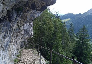
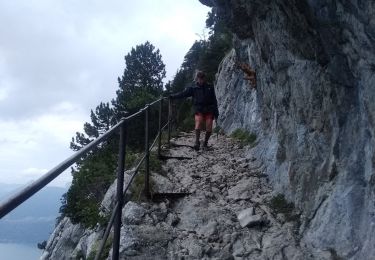
Depuis le parking montée dans le bois en période de pluie cette montée est très glissante et raide.
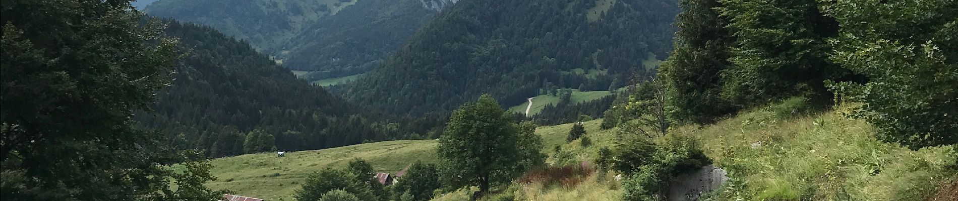
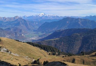
Le paysage en haut du mont est magnifique: vue sur les sommets des Alpes , Mont Blanc, grande Casse …
Localización
País:
France
Región :
Auvergne-Rhône-Alpes
Departamento/provincia :
Saboya
Municipio :
Doucy-en-Bauges
Localidad:
Unknown
Salida:(Dec)
Salida:(UTM)
279858 ; 5064452 (32T) N.
Comentarios
Excursiones cerca
![Excursión Senderismo Jarsy - BAUGES: PRECHEREL - CROIX D'ALLANT - PLAN DE LA LIMACE - en direction du Mont de la Coche - Photo](https://media.geolcdn.com/t/375/260/a1c1a220-f26a-4fbe-a6ad-eda1f1982f07.jpg&format=jpg&maxdim=2)
![Senderismo Senderismo](https://static1.geolcdn.com/sitytour/trail-icons/101.png)
BAUGES: PRECHEREL - CROIX D'ALLANT - PLAN DE LA LIMACE - en direction du Mont...
Senderismo
Difícil
(1)
Jarsy,
Auvergne-Rhône-Alpes,
Saboya,
France
![](/images/other/stat-length.png)
13,1 km | 24 km-effort
4h 45min
![](https://static1.geolcdn.com/siteimages/upload/files/16400158638029165_repeat_loop_refresh_sync_direction_icon.png)
Sí
![Excursión Senderismo Doucy-en-Bauges - Traversée du Mont Trélod, 2181m - Photo](https://media.geolcdn.com/t/375/260/ext.jpg?maxdim=2&url=https%3A%2F%2Fservices.sitytrail.com%2FGeolivesWS%2FDownloadMedia.ashx%3FTrailID%3D103833%26Media%3D6623_1.jpg)
![Senderismo Senderismo](https://static1.geolcdn.com/sitytour/trail-icons/101.png)
Traversée du Mont Trélod, 2181m
Senderismo
Medio
(1)
Doucy-en-Bauges,
Auvergne-Rhône-Alpes,
Saboya,
France
![](/images/other/stat-length.png)
10,9 km | 28 km-effort
7h 30min
![](https://static1.geolcdn.com/siteimages/upload/files/16400158638029165_repeat_loop_refresh_sync_direction_icon.png)
No
![Excursión Senderismo Bellecombe-en-Bauges - Pointe de Banc Plat en boucle - Photo](https://media.geolcdn.com/t/375/260/80b75f38-16b0-40b8-9a99-ebc551fd27ff.jpg&format=jpg&maxdim=2)
![Senderismo Senderismo](https://static1.geolcdn.com/sitytour/trail-icons/101.png)
Pointe de Banc Plat en boucle
Senderismo
Difícil
Bellecombe-en-Bauges,
Auvergne-Rhône-Alpes,
Saboya,
France
![](/images/other/stat-length.png)
13,8 km | 27 km-effort
4h 1min
![](https://static1.geolcdn.com/siteimages/upload/files/16400158638029165_repeat_loop_refresh_sync_direction_icon.png)
Sí
![Excursión Esquí de fondo Bellecombe-en-Bauges - la dent des portes et sous le Trelod - Photo](https://media.geolcdn.com/t/375/260/5df2df97-f7db-4fea-9d78-8be71e3fb466.jpg&format=jpg&maxdim=2)
![Esquí de fondo Esquí de fondo](https://static1.geolcdn.com/sitytour/trail-icons/503.png)
la dent des portes et sous le Trelod
Esquí de fondo
Medio
Bellecombe-en-Bauges,
Auvergne-Rhône-Alpes,
Saboya,
France
![](/images/other/stat-length.png)
12,9 km | 29 km-effort
3h 52min
![](https://static1.geolcdn.com/siteimages/upload/files/16400158638029165_repeat_loop_refresh_sync_direction_icon.png)
Sí
![Excursión Esquí de fondo Le Châtelard - col de Rossanaz - Photo](https://media.geolcdn.com/t/375/260/50e32d24-befc-4efc-87ab-b6a2311f6d3b.jpg&format=jpg&maxdim=2)
![Esquí de fondo Esquí de fondo](https://static1.geolcdn.com/sitytour/trail-icons/503.png)
col de Rossanaz
Esquí de fondo
Difícil
Le Châtelard,
Auvergne-Rhône-Alpes,
Saboya,
France
![](/images/other/stat-length.png)
10,6 km | 24 km-effort
5h 0min
![](https://static1.geolcdn.com/siteimages/upload/files/16400158638029165_repeat_loop_refresh_sync_direction_icon.png)
Sí
![Excursión Senderismo Le Châtelard - Roc poyet - Photo](https://media.geolcdn.com/t/375/260/a503fd55-09ac-42bc-9003-547472a05706.jpg&format=jpg&maxdim=2)
![Senderismo Senderismo](https://static1.geolcdn.com/sitytour/trail-icons/101.png)
Roc poyet
Senderismo
Medio
Le Châtelard,
Auvergne-Rhône-Alpes,
Saboya,
France
![](/images/other/stat-length.png)
8,2 km | 19,8 km-effort
5h 6min
![](https://static1.geolcdn.com/siteimages/upload/files/16400158638029165_repeat_loop_refresh_sync_direction_icon.png)
Sí
![Excursión Senderismo Bellecombe-en-Bauges - Banc plat boucle - Photo](https://media.geolcdn.com/t/375/260/a2db89fd-d92b-448f-a4ef-41a90ffed31c.jpg&format=jpg&maxdim=2)
![Senderismo Senderismo](https://static1.geolcdn.com/sitytour/trail-icons/101.png)
Banc plat boucle
Senderismo
Difícil
Bellecombe-en-Bauges,
Auvergne-Rhône-Alpes,
Saboya,
France
![](/images/other/stat-length.png)
10,7 km | 21 km-effort
4h 52min
![](https://static1.geolcdn.com/siteimages/upload/files/16400158638029165_repeat_loop_refresh_sync_direction_icon.png)
Sí
![Excursión Senderismo Doucy-en-Bauges - 2015-09-11 Marche Mont Trelod - Photo](https://media.geolcdn.com/t/375/260/ext.jpg?maxdim=2&url=https%3A%2F%2Fstatic1.geolcdn.com%2Fsiteimages%2Fupload%2Ffiles%2F1553511878bg_sport_marche.png)
![Senderismo Senderismo](https://static1.geolcdn.com/sitytour/trail-icons/101.png)
2015-09-11 Marche Mont Trelod
Senderismo
Medio
(1)
Doucy-en-Bauges,
Auvergne-Rhône-Alpes,
Saboya,
France
![](/images/other/stat-length.png)
12,4 km | 28 km-effort
5h 25min
![](https://static1.geolcdn.com/siteimages/upload/files/16400158638029165_repeat_loop_refresh_sync_direction_icon.png)
Sí
![Excursión Senderismo Bellecombe-en-Bauges - BAUGES: BANC PLAT via REPOSOIR - BORNETTE - REFUGE COMBE - Photo](https://media.geolcdn.com/t/375/260/e352fcdc-17f0-46fd-b7a7-5ac4f4bb5365.jpg&format=jpg&maxdim=2)
![Senderismo Senderismo](https://static1.geolcdn.com/sitytour/trail-icons/101.png)
BAUGES: BANC PLAT via REPOSOIR - BORNETTE - REFUGE COMBE
Senderismo
Difícil
Bellecombe-en-Bauges,
Auvergne-Rhône-Alpes,
Saboya,
France
![](/images/other/stat-length.png)
15,3 km | 27 km-effort
6h 13min
![](https://static1.geolcdn.com/siteimages/upload/files/16400158638029165_repeat_loop_refresh_sync_direction_icon.png)
Sí