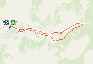
![](/images/other/stat-length.png)
![Excursión Senderismo Champoléon - Champoléon - Refuge du pré de la Chaumette - Photo](https://media.geolcdn.com/t/1900/400/ext.pjpeg?maxdim=2&url=https%3A%2F%2Fstatic1.geolcdn.com%2Fsiteimages%2Fupload%2Ffiles%2F1553511878bg_sport_marche.png)
Champoléon - Refuge du pré de la Chaumette
pourrier
Usuario
![Longitud](/images/other/stat-length.png)
![Altitud máxima](https://static1.geolcdn.com/siteimages/upload/files/1508320355ic_sort_altitude_max_24dp.png)
![Desnivel positivo](https://static1.geolcdn.com/siteimages/upload/files/1508320355ic_sort_den_pos_24dp.png)
![Km-Effort](/images/other/stat-length.png)
![Altitud mínima](https://static1.geolcdn.com/siteimages/upload/files/1508320355ic_sort_altitude_min_24dp.png)
![Desnivel negativo](https://static1.geolcdn.com/siteimages/upload/files/1508320355ic_sort_den_neg_24dp.png)
![Boucle](https://static1.geolcdn.com/siteimages/upload/files/16400158638029165_repeat_loop_refresh_sync_direction_icon.png)
![Senderismo](https://static1.geolcdn.com/sitytour/trail-icons/101.png)
3h31
Dificultad : Medio
![Escanee este código QR para abrir la excursión en la aplicación SityTrail](https://capi.geolives.com/qq0zvz2zws4bq2lad0pu/sitytour/trails/2877174/qr.png?size=200)
Aplicación GPS de excursión GRATIS
A propósito
Ruta Senderismo de 10 km a descubrir en Provenza-Alpes-Costa Azul, Altos Alpes, Champoléon. Esta ruta ha sido propuesta por pourrier.
Descripción
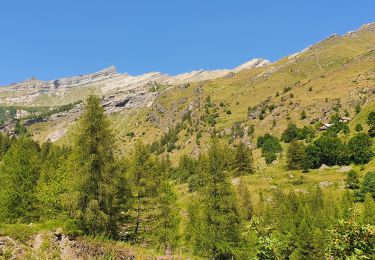
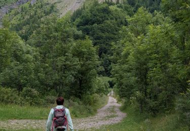
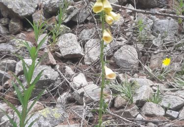
Belle promenade de 3h30 depuis le parking des Auberts jusqu'au refuge du Pré de la Chaumette.
Démarrage par un gros éboulis, situé sur la rive droite du Drac Blanc et ensuite le chemin est confortable.
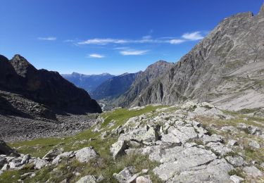
Retour depuis le refuge par la rive gauche (piste pourriture montant au refuge) pour admirer la cascade des Prelles.
Localización
Comentarios
Excursiones cerca
![Excursión Senderismo Champoléon - Lac Surat ou lac de Prelle - Photo](https://media.geolcdn.com/t/375/260/d8b66f59-3dd4-41c8-8493-8bdffe49ada9.jpg&format=jpg&maxdim=2)
![Senderismo Senderismo](https://static1.geolcdn.com/sitytour/trail-icons/101.png)
Senderismo
![](/images/other/stat-length.png)
![](https://static1.geolcdn.com/siteimages/upload/files/16400158638029165_repeat_loop_refresh_sync_direction_icon.png)
![Excursión A pie Champoléon - Refuge du Tourond - Photo](https://media.geolcdn.com/t/375/260/42cbf5d1-e48d-4896-9483-7cb6a380b211.jpg&format=jpg&maxdim=2)
![A pie A pie](https://static1.geolcdn.com/sitytour/trail-icons/100.png)
A pie
![](/images/other/stat-length.png)
![](https://static1.geolcdn.com/siteimages/upload/files/16400158638029165_repeat_loop_refresh_sync_direction_icon.png)
![Excursión Senderismo Champoléon - Méollion - Photo](https://media.geolcdn.com/t/375/260/da24cc78-a99a-4fa8-9dce-d97d6d7f39a5.jpg&format=jpg&maxdim=2)
![Senderismo Senderismo](https://static1.geolcdn.com/sitytour/trail-icons/101.png)
Senderismo
![](/images/other/stat-length.png)
![](https://static1.geolcdn.com/siteimages/upload/files/16400158638029165_repeat_loop_refresh_sync_direction_icon.png)
![Senderismo Senderismo](https://static1.geolcdn.com/sitytour/trail-icons/101.png)
Senderismo
![](/images/other/stat-length.png)
![](https://static1.geolcdn.com/siteimages/upload/files/16400158638029165_repeat_loop_refresh_sync_direction_icon.png)
![Excursión Senderismo Champoléon - Balade Vallée Champoléon - Photo](https://media.geolcdn.com/t/375/260/23c779ce-adcf-411d-9db1-4b3234bce8ff.jpg&format=jpg&maxdim=2)
![Senderismo Senderismo](https://static1.geolcdn.com/sitytour/trail-icons/101.png)
Senderismo
![](/images/other/stat-length.png)
![](https://static1.geolcdn.com/siteimages/upload/files/16400158638029165_repeat_loop_refresh_sync_direction_icon.png)
![Excursión Senderismo Champoléon - Refuge Tourond + Cascade 28/07/20 - Photo](https://media.geolcdn.com/t/375/260/e7d034e9-7e3b-42ad-9caa-76a3aa68be48.jpg&format=jpg&maxdim=2)
![Senderismo Senderismo](https://static1.geolcdn.com/sitytour/trail-icons/101.png)
Senderismo
![](/images/other/stat-length.png)
![](https://static1.geolcdn.com/siteimages/upload/files/16400158638029165_repeat_loop_refresh_sync_direction_icon.png)
![Excursión Senderismo Champoléon - refuge du Tourond et cascade de la pisse - Photo](https://media.geolcdn.com/t/375/260/3023f38b-7f7f-4485-a753-4fb70a0a097f.jpg&format=jpg&maxdim=2)
![Senderismo Senderismo](https://static1.geolcdn.com/sitytour/trail-icons/101.png)
Senderismo
![](/images/other/stat-length.png)
![](https://static1.geolcdn.com/siteimages/upload/files/16400158638029165_repeat_loop_refresh_sync_direction_icon.png)
![Excursión Senderismo Champoléon - PARC NATIONAL DES ECRINS: LACS DE CRUPILOUSE - Photo](https://media.geolcdn.com/t/375/260/ffca484e-6696-440e-b65f-eed34e1ad21b.jpg&format=jpg&maxdim=2)
![Senderismo Senderismo](https://static1.geolcdn.com/sitytour/trail-icons/101.png)
Senderismo
![](/images/other/stat-length.png)
![](https://static1.geolcdn.com/siteimages/upload/files/16400158638029165_repeat_loop_refresh_sync_direction_icon.png)
![Excursión Senderismo Champoléon - Champoleon . - Photo](https://media.geolcdn.com/t/375/260/bc863020-364c-4571-8d00-7c075c354f01.jpg&format=jpg&maxdim=2)
![Senderismo Senderismo](https://static1.geolcdn.com/sitytour/trail-icons/101.png)
Senderismo
![](/images/other/stat-length.png)
![](https://static1.geolcdn.com/siteimages/upload/files/16400158638029165_repeat_loop_refresh_sync_direction_icon.png)