![](/images/other/stat-length.png)
![Excursión Senderismo Ceyssat - Du Puy-de-Dôme au Pariou - Photo](https://media.geolcdn.com/t/1900/400/08780798-8cfe-4c11-a7be-0e4c36272c9c.jpg&format=pjpeg&maxdim=2)
Du Puy-de-Dôme au Pariou
dauzata
Usuario
![Longitud](/images/other/stat-length.png)
Longitud
13,4 km
![Altitud máxima](https://static1.geolcdn.com/siteimages/upload/files/1508320355ic_sort_altitude_max_24dp.png)
Altitud máxima
1462 m
![Desnivel positivo](https://static1.geolcdn.com/siteimages/upload/files/1508320355ic_sort_den_pos_24dp.png)
Desnivel positivo
673 m
![Km-Effort](/images/other/stat-length.png)
Km-Effort
22 km
![Altitud mínima](https://static1.geolcdn.com/siteimages/upload/files/1508320355ic_sort_altitude_min_24dp.png)
Altitud mínima
1061 m
![Desnivel negativo](https://static1.geolcdn.com/siteimages/upload/files/1508320355ic_sort_den_neg_24dp.png)
Desnivel negativo
675 m
![Boucle](https://static1.geolcdn.com/siteimages/upload/files/16400158638029165_repeat_loop_refresh_sync_direction_icon.png)
Boucle
Sí
Fecha de creación :
2021-07-27 09:04:00.0
Última modificación :
2021-07-29 20:46:27.623
![Senderismo](https://static1.geolcdn.com/sitytour/trail-icons/101.png)
5h00
Dificultad : Difícil
![Escanee este código QR para abrir la excursión en la aplicación SityTrail](https://capi.geolives.com/qq0zvz2zws4bq2lad0pu/sitytour/trails/2876026/qr.png?size=200)
Aplicación GPS de excursión GRATIS
A propósito
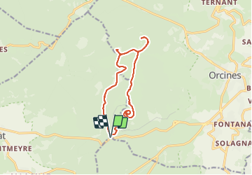
Ruta Senderismo de 13,4 km a descubrir en Auvergne-Rhône-Alpes, Puy-de-Dôme, Ceyssat. Esta ruta ha sido propuesta por dauzata.
Descripción
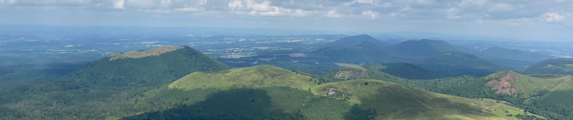
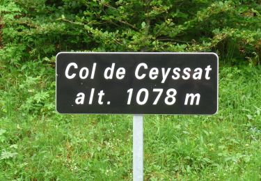
Départ du Col de Ceyssat. Puy-de-Dôme, Pariou et Cliersou.
Le roi de la région est omniprésent.
Localización
País:
France
Región :
Auvergne-Rhône-Alpes
Departamento/provincia :
Puy-de-Dôme
Municipio :
Ceyssat
Localidad:
Unknown
Salida:(Dec)
Salida:(UTM)
496536 ; 5067840 (31T) N.
Comentarios
Excursiones cerca
![Excursión Senderismo Orcines - Ceyssat_Puy_Dome - Photo](https://media.geolcdn.com/t/375/260/8756d4a5-24c7-4a55-b3cb-4d4af6c029f8.jpg&format=jpg&maxdim=2)
![Senderismo Senderismo](https://static1.geolcdn.com/sitytour/trail-icons/101.png)
Ceyssat_Puy_Dome
Senderismo
Medio
(2)
Orcines,
Auvergne-Rhône-Alpes,
Puy-de-Dôme,
France
![](/images/other/stat-length.png)
7,3 km | 12,3 km-effort
2h 15min
![](https://static1.geolcdn.com/siteimages/upload/files/16400158638029165_repeat_loop_refresh_sync_direction_icon.png)
Sí
![Excursión Senderismo Orcines - Puy de Pariou - Photo](https://media.geolcdn.com/t/375/260/ext.jpg?maxdim=2&url=https%3A%2F%2Fservices.sitytrail.com%2FGeolivesWS%2FDownloadMedia.ashx%3FTrailID%3D146546%26Media%3D20120813113037.jpeg)
![Senderismo Senderismo](https://static1.geolcdn.com/sitytour/trail-icons/101.png)
Puy de Pariou
Senderismo
Medio
(1)
Orcines,
Auvergne-Rhône-Alpes,
Puy-de-Dôme,
France
![](/images/other/stat-length.png)
8,6 km | 12,4 km-effort
3h 7min
![](https://static1.geolcdn.com/siteimages/upload/files/16400158638029165_repeat_loop_refresh_sync_direction_icon.png)
Sí
![Excursión Senderismo Orcines - Le tour du Puy de Dôme - Photo](https://media.geolcdn.com/t/375/260/ext.jpg?maxdim=2&url=https%3A%2F%2Fservices.sitytrail.com%2FGeolivesWS%2FDownloadMedia.ashx%3FTrailID%3D102862%26Media%3D4049_1.jpg)
![Senderismo Senderismo](https://static1.geolcdn.com/sitytour/trail-icons/101.png)
Le tour du Puy de Dôme
Senderismo
Difícil
(1)
Orcines,
Auvergne-Rhône-Alpes,
Puy-de-Dôme,
France
![](/images/other/stat-length.png)
12,2 km | 17,3 km-effort
3h 0min
![](https://static1.geolcdn.com/siteimages/upload/files/16400158638029165_repeat_loop_refresh_sync_direction_icon.png)
Sí
![Excursión Senderismo Orcines - Le Puy de Montrodeix par Orcines - Photo](https://media.geolcdn.com/t/375/260/ext.jpg?maxdim=2&url=https%3A%2F%2Fservices.sitytrail.com%2FGeolivesWS%2FDownloadMedia.ashx%3FTrailID%3D101852%26Media%3D2138_1.jpg)
![Senderismo Senderismo](https://static1.geolcdn.com/sitytour/trail-icons/101.png)
Le Puy de Montrodeix par Orcines
Senderismo
Difícil
(1)
Orcines,
Auvergne-Rhône-Alpes,
Puy-de-Dôme,
France
![](/images/other/stat-length.png)
11,1 km | 14,5 km-effort
3h 30min
![](https://static1.geolcdn.com/siteimages/upload/files/16400158638029165_repeat_loop_refresh_sync_direction_icon.png)
Sí
![Excursión Senderismo Ceyssat - puy de dôme et périphérie - Photo](https://media.geolcdn.com/t/375/260/2d42b48f-ecf0-4816-ac26-6f6eefb103b2.jpg&format=jpg&maxdim=2)
![Senderismo Senderismo](https://static1.geolcdn.com/sitytour/trail-icons/101.png)
puy de dôme et périphérie
Senderismo
Difícil
Ceyssat,
Auvergne-Rhône-Alpes,
Puy-de-Dôme,
France
![](/images/other/stat-length.png)
11,1 km | 18 km-effort
6h 20min
![](https://static1.geolcdn.com/siteimages/upload/files/16400158638029165_repeat_loop_refresh_sync_direction_icon.png)
No
![Excursión Senderismo Orcines - Montée au Puy de Dôme et temple de Mercure - Photo](https://media.geolcdn.com/t/375/260/00c0b77e-7bc2-4fc2-95b2-8a871683bc46.jpg&format=jpg&maxdim=2)
![Senderismo Senderismo](https://static1.geolcdn.com/sitytour/trail-icons/101.png)
Montée au Puy de Dôme et temple de Mercure
Senderismo
Difícil
Orcines,
Auvergne-Rhône-Alpes,
Puy-de-Dôme,
France
![](/images/other/stat-length.png)
8,7 km | 14,5 km-effort
2h 31min
![](https://static1.geolcdn.com/siteimages/upload/files/16400158638029165_repeat_loop_refresh_sync_direction_icon.png)
Sí
![Excursión A pie Ceyssat - Le Puy de Dôme - Photo](https://media.geolcdn.com/t/375/260/f9f5731c-b5b9-4dd4-860e-ddf045002922.jpeg&format=jpg&maxdim=2)
![A pie A pie](https://static1.geolcdn.com/sitytour/trail-icons/100.png)
Le Puy de Dôme
A pie
Fácil
Ceyssat,
Auvergne-Rhône-Alpes,
Puy-de-Dôme,
France
![](/images/other/stat-length.png)
7 km | 12 km-effort
2h 44min
![](https://static1.geolcdn.com/siteimages/upload/files/16400158638029165_repeat_loop_refresh_sync_direction_icon.png)
Sí
![Excursión A pie Saint-Genès-Champanelle - Mazaye / Laschamp - Photo](https://media.geolcdn.com/t/375/260/56c26b29-05c9-4d34-ac35-c8d50fdff323.jpeg&format=jpg&maxdim=2)
![A pie A pie](https://static1.geolcdn.com/sitytour/trail-icons/100.png)
Mazaye / Laschamp
A pie
Medio
Saint-Genès-Champanelle,
Auvergne-Rhône-Alpes,
Puy-de-Dôme,
France
![](/images/other/stat-length.png)
21 km | 30 km-effort
6h 46min
![](https://static1.geolcdn.com/siteimages/upload/files/16400158638029165_repeat_loop_refresh_sync_direction_icon.png)
No
![Excursión A pie Orcines - Le Tour du Puy de Dome - Photo](https://media.geolcdn.com/t/375/260/9e74b4f6-5492-45c6-9c64-0e352f21de53.jpeg&format=jpg&maxdim=2)
![A pie A pie](https://static1.geolcdn.com/sitytour/trail-icons/100.png)
Le Tour du Puy de Dome
A pie
Fácil
Orcines,
Auvergne-Rhône-Alpes,
Puy-de-Dôme,
France
![](/images/other/stat-length.png)
9,4 km | 12,8 km-effort
2h 54min
![](https://static1.geolcdn.com/siteimages/upload/files/16400158638029165_repeat_loop_refresh_sync_direction_icon.png)
Sí