![](/images/other/stat-length.png)
![Excursión Senderismo Eygliers - tourdelagardiole250721 - Photo](https://media.geolcdn.com/t/1900/400/ext.pjpeg?maxdim=2&url=https%3A%2F%2Fstatic1.geolcdn.com%2Fsiteimages%2Fupload%2Ffiles%2F1553511878bg_sport_marche.png)
tourdelagardiole250721
annehc
Usuario
![Longitud](/images/other/stat-length.png)
Longitud
11,7 km
![Altitud máxima](https://static1.geolcdn.com/siteimages/upload/files/1508320355ic_sort_altitude_max_24dp.png)
Altitud máxima
1592 m
![Desnivel positivo](https://static1.geolcdn.com/siteimages/upload/files/1508320355ic_sort_den_pos_24dp.png)
Desnivel positivo
655 m
![Km-Effort](/images/other/stat-length.png)
Km-Effort
20 km
![Altitud mínima](https://static1.geolcdn.com/siteimages/upload/files/1508320355ic_sort_altitude_min_24dp.png)
Altitud mínima
1002 m
![Desnivel negativo](https://static1.geolcdn.com/siteimages/upload/files/1508320355ic_sort_den_neg_24dp.png)
Desnivel negativo
656 m
![Boucle](https://static1.geolcdn.com/siteimages/upload/files/16400158638029165_repeat_loop_refresh_sync_direction_icon.png)
Boucle
Sí
Fecha de creación :
2021-07-25 08:17:53.452
Última modificación :
2021-07-25 13:45:31.436
![Senderismo](https://static1.geolcdn.com/sitytour/trail-icons/101.png)
4h37
Dificultad : Muy difícil
![Escanee este código QR para abrir la excursión en la aplicación SityTrail](https://capi.geolives.com/qq0zvz2zws4bq2lad0pu/sitytour/trails/2873511/qr.png?size=200)
Aplicación GPS de excursión GRATIS
A propósito
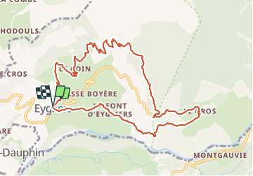
Ruta Senderismo de 11,7 km a descubrir en Provenza-Alpes-Costa Azul, Altos Alpes, Eygliers. Esta ruta ha sido propuesta por annehc.
Descripción
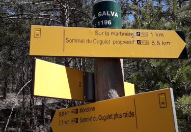
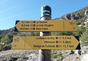
n7 topo queyras et guillestrois à pied
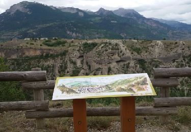
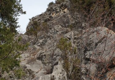
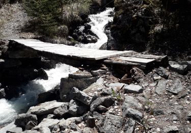
arrêt pique nique au top. descentes plus escarpées. trop de routes
Localización
País:
France
Región :
Provenza-Alpes-Costa Azul
Departamento/provincia :
Altos Alpes
Municipio :
Eygliers
Localidad:
Unknown
Salida:(Dec)
Salida:(UTM)
312490 ; 4949718 (32T) N.
Comentarios
Excursiones cerca
![Excursión Senderismo Guillestre - Rue des Masques - Photo](https://media.geolcdn.com/t/375/260/ext.jpg?maxdim=2&url=https%3A%2F%2Fservices.sitytrail.com%2FGeolivesWS%2FDownloadMedia.ashx%3FTrailID%3D313087%26Media%3Dfix__20140615165550.jpg)
![Senderismo Senderismo](https://static1.geolcdn.com/sitytour/trail-icons/101.png)
Rue des Masques
Senderismo
Muy fácil
(1)
Guillestre,
Provenza-Alpes-Costa Azul,
Altos Alpes,
France
![](/images/other/stat-length.png)
5,1 km | 7,9 km-effort
1h 47min
![](https://static1.geolcdn.com/siteimages/upload/files/16400158638029165_repeat_loop_refresh_sync_direction_icon.png)
Sí
![Excursión Senderismo Eygliers - crots les Girars - Photo](https://media.geolcdn.com/t/375/260/1984f172-53b4-4530-81bd-f8dbb8a69056.jpg&format=jpg&maxdim=2)
![Senderismo Senderismo](https://static1.geolcdn.com/sitytour/trail-icons/101.png)
crots les Girars
Senderismo
Medio
(1)
Eygliers,
Provenza-Alpes-Costa Azul,
Altos Alpes,
France
![](/images/other/stat-length.png)
10,2 km | 16,9 km-effort
3h 41min
![](https://static1.geolcdn.com/siteimages/upload/files/16400158638029165_repeat_loop_refresh_sync_direction_icon.png)
Sí
![Excursión Senderismo Eygliers - eygliers - Photo](https://media.geolcdn.com/t/375/260/4d2fa757-82b4-42b5-b98d-a01be8317965.jpg&format=jpg&maxdim=2)
![Senderismo Senderismo](https://static1.geolcdn.com/sitytour/trail-icons/101.png)
eygliers
Senderismo
Medio
Eygliers,
Provenza-Alpes-Costa Azul,
Altos Alpes,
France
![](/images/other/stat-length.png)
6,3 km | 9 km-effort
2h 7min
![](https://static1.geolcdn.com/siteimages/upload/files/16400158638029165_repeat_loop_refresh_sync_direction_icon.png)
Sí
![Excursión Senderismo Saint-Crépin - St Crépin Thurifère vers hameau de Guion Chantal - Photo](https://media.geolcdn.com/t/375/260/c1ee07d4-05f0-443a-a59c-bf145194c732.jpg&format=jpg&maxdim=2)
![Senderismo Senderismo](https://static1.geolcdn.com/sitytour/trail-icons/101.png)
St Crépin Thurifère vers hameau de Guion Chantal
Senderismo
Difícil
Saint-Crépin,
Provenza-Alpes-Costa Azul,
Altos Alpes,
France
![](/images/other/stat-length.png)
5 km | 9,9 km-effort
2h 30min
![](https://static1.geolcdn.com/siteimages/upload/files/16400158638029165_repeat_loop_refresh_sync_direction_icon.png)
Sí
![Excursión Senderismo Guillestre - Roche Rousse et Rocher de l'aigle à Guillestre - Photo](https://media.geolcdn.com/t/375/260/ef83071a-a3e5-4323-a0d2-2f834a181802.jpg&format=jpg&maxdim=2)
![Senderismo Senderismo](https://static1.geolcdn.com/sitytour/trail-icons/101.png)
Roche Rousse et Rocher de l'aigle à Guillestre
Senderismo
Medio
Guillestre,
Provenza-Alpes-Costa Azul,
Altos Alpes,
France
![](/images/other/stat-length.png)
8,6 km | 14 km-effort
2h 52min
![](https://static1.geolcdn.com/siteimages/upload/files/16400158638029165_repeat_loop_refresh_sync_direction_icon.png)
Sí
![Excursión Senderismo Eygliers - Gros cabannes Tourouder - Photo](https://media.geolcdn.com/t/375/260/316d45c1-9e6e-42ed-8767-48fc2893efef.jpg&format=jpg&maxdim=2)
![Senderismo Senderismo](https://static1.geolcdn.com/sitytour/trail-icons/101.png)
Gros cabannes Tourouder
Senderismo
Medio
Eygliers,
Provenza-Alpes-Costa Azul,
Altos Alpes,
France
![](/images/other/stat-length.png)
14,7 km | 27 km-effort
4h 32min
![](https://static1.geolcdn.com/siteimages/upload/files/16400158638029165_repeat_loop_refresh_sync_direction_icon.png)
Sí
![Excursión Senderismo Risoul - Le Villaret plan Phazy - Photo](https://media.geolcdn.com/t/375/260/cf32f774-53da-40e4-b349-6bec0523a9a8.jpg&format=jpg&maxdim=2)
![Senderismo Senderismo](https://static1.geolcdn.com/sitytour/trail-icons/101.png)
Le Villaret plan Phazy
Senderismo
Medio
Risoul,
Provenza-Alpes-Costa Azul,
Altos Alpes,
France
![](/images/other/stat-length.png)
10,9 km | 16,5 km-effort
3h 11min
![](https://static1.geolcdn.com/siteimages/upload/files/16400158638029165_repeat_loop_refresh_sync_direction_icon.png)
Sí
![Excursión Senderismo Guillestre - Le Villaret Barbein - Photo](https://media.geolcdn.com/t/375/260/f6ed42fb-b264-4215-a06b-e5ea1f50a695.jpg&format=jpg&maxdim=2)
![Senderismo Senderismo](https://static1.geolcdn.com/sitytour/trail-icons/101.png)
Le Villaret Barbein
Senderismo
Medio
Guillestre,
Provenza-Alpes-Costa Azul,
Altos Alpes,
France
![](/images/other/stat-length.png)
10,2 km | 16,2 km-effort
3h 7min
![](https://static1.geolcdn.com/siteimages/upload/files/16400158638029165_repeat_loop_refresh_sync_direction_icon.png)
Sí
![Excursión Senderismo Guillestre - Risoul le Villaret Brunissard - Photo](https://media.geolcdn.com/t/375/260/65245f84-1b3b-4410-810c-881d6a3536a1.jpg&format=jpg&maxdim=2)
![Senderismo Senderismo](https://static1.geolcdn.com/sitytour/trail-icons/101.png)
Risoul le Villaret Brunissard
Senderismo
Fácil
Guillestre,
Provenza-Alpes-Costa Azul,
Altos Alpes,
France
![](/images/other/stat-length.png)
9,3 km | 14,9 km-effort
3h 0min
![](https://static1.geolcdn.com/siteimages/upload/files/16400158638029165_repeat_loop_refresh_sync_direction_icon.png)
Sí