![](/images/other/stat-length.png)
![Excursión Senderismo Saillagouse - Le Roc de Cabernet - Photo](https://media.geolcdn.com/t/1900/400/ext.pjpeg?maxdim=2&url=https%3A%2F%2Fstatic1.geolcdn.com%2Fsiteimages%2Fupload%2Ffiles%2F1553511878bg_sport_marche.png)
Le Roc de Cabernet
rene091957
Usuario
![Longitud](/images/other/stat-length.png)
Longitud
15,7 km
![Altitud máxima](https://static1.geolcdn.com/siteimages/upload/files/1508320355ic_sort_altitude_max_24dp.png)
Altitud máxima
1963 m
![Desnivel positivo](https://static1.geolcdn.com/siteimages/upload/files/1508320355ic_sort_den_pos_24dp.png)
Desnivel positivo
715 m
![Km-Effort](/images/other/stat-length.png)
Km-Effort
25 km
![Altitud mínima](https://static1.geolcdn.com/siteimages/upload/files/1508320355ic_sort_altitude_min_24dp.png)
Altitud mínima
1303 m
![Desnivel negativo](https://static1.geolcdn.com/siteimages/upload/files/1508320355ic_sort_den_neg_24dp.png)
Desnivel negativo
714 m
![Boucle](https://static1.geolcdn.com/siteimages/upload/files/16400158638029165_repeat_loop_refresh_sync_direction_icon.png)
Boucle
Sí
Fecha de creación :
2021-07-23 12:21:49.095
Última modificación :
2021-07-23 12:47:06.73
![Senderismo](https://static1.geolcdn.com/sitytour/trail-icons/101.png)
5h44
Dificultad : Muy difícil
![Escanee este código QR para abrir la excursión en la aplicación SityTrail](https://capi.geolives.com/qq0zvz2zws4bq2lad0pu/sitytour/trails/2871126/qr.png?size=200)
Aplicación GPS de excursión GRATIS
A propósito
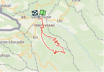
Ruta Senderismo de 15,7 km a descubrir en Occitania, Pirineos Orientales, Saillagouse. Esta ruta ha sido propuesta por rene091957.
Descripción
Place des Commerces à Saillagouse, hameau de Védrinyans, piste forestière de Saillagouse, Roc de Cabernet, refuge du Cami de Nuria, Err-le-Haut, Védrinyans, saillagouse.
Localización
País:
France
Región :
Occitania
Departamento/provincia :
Pirineos Orientales
Municipio :
Saillagouse
Localidad:
Unknown
Salida:(Dec)
Salida:(UTM)
420828 ; 4700929 (31T) N.
Comentarios
Excursiones cerca
![Excursión Senderismo Nahuja - boucle de Nahuja - Photo](https://media.geolcdn.com/t/375/260/ext.jpg?maxdim=2&url=https%3A%2F%2Fservices.sitytrail.com%2FGeolivesWS%2FDownloadMedia.ashx%3FTrailID%3D558835%26Media%3D20160425135530.jpg)
![Senderismo Senderismo](https://static1.geolcdn.com/sitytour/trail-icons/101.png)
boucle de Nahuja
Senderismo
Medio
(1)
Nahuja,
Occitania,
Pirineos Orientales,
France
![](/images/other/stat-length.png)
11,8 km | 18,2 km-effort
2h 44min
![](https://static1.geolcdn.com/siteimages/upload/files/16400158638029165_repeat_loop_refresh_sync_direction_icon.png)
Sí
![Excursión Senderismo Eyne - Eyne,col de Nuria,pic d'Eyne,Torre d'Eyne,Eyne. - Photo](https://media.geolcdn.com/t/375/260/ext.jpg?maxdim=2&url=https%3A%2F%2Fservices.sitytrail.com%2FGeolivesWS%2FDownloadMedia.ashx%3FTrailID%3D530520%26Media%3D20150811115220.jpg)
![Senderismo Senderismo](https://static1.geolcdn.com/sitytour/trail-icons/101.png)
Eyne,col de Nuria,pic d'Eyne,Torre d'Eyne,Eyne.
Senderismo
Muy difícil
(1)
Eyne,
Occitania,
Pirineos Orientales,
France
![](/images/other/stat-length.png)
24 km | 43 km-effort
8h 44min
![](https://static1.geolcdn.com/siteimages/upload/files/16400158638029165_repeat_loop_refresh_sync_direction_icon.png)
Sí
![Excursión Senderismo Font-Romeu-Odeillo-Via - Font Romeu Egat - Photo](https://media.geolcdn.com/t/375/260/ext.jpg?maxdim=2&url=https%3A%2F%2Fservices.sitytrail.com%2FGeolivesWS%2FDownloadMedia.ashx%3FTrailID%3D555215%26Media%3D20160418074519.jpg)
![Senderismo Senderismo](https://static1.geolcdn.com/sitytour/trail-icons/101.png)
Font Romeu Egat
Senderismo
Medio
(2)
Font-Romeu-Odeillo-Via,
Occitania,
Pirineos Orientales,
France
![](/images/other/stat-length.png)
2,5 km | 3,4 km-effort
44min
![](https://static1.geolcdn.com/siteimages/upload/files/16400158638029165_repeat_loop_refresh_sync_direction_icon.png)
Sí
![Excursión Senderismo Eyne - Vallée d'Eyne - Photo](https://media.geolcdn.com/t/375/260/93dd56ed-3f9b-487e-93c8-7f2ec1ca29ff.jpg&format=jpg&maxdim=2)
![Senderismo Senderismo](https://static1.geolcdn.com/sitytour/trail-icons/101.png)
Vallée d'Eyne
Senderismo
Medio
Eyne,
Occitania,
Pirineos Orientales,
France
![](/images/other/stat-length.png)
10,7 km | 17,6 km-effort
4h 40min
![](https://static1.geolcdn.com/siteimages/upload/files/16400158638029165_repeat_loop_refresh_sync_direction_icon.png)
Sí
![Excursión Senderismo Eyne - eyne - Photo](https://media.geolcdn.com/t/375/260/ext.jpg?maxdim=2&url=https%3A%2F%2Fstatic1.geolcdn.com%2Fsiteimages%2Fupload%2Ffiles%2F1553511878bg_sport_marche.png)
![Senderismo Senderismo](https://static1.geolcdn.com/sitytour/trail-icons/101.png)
eyne
Senderismo
Medio
(2)
Eyne,
Occitania,
Pirineos Orientales,
France
![](/images/other/stat-length.png)
6,2 km | 8,2 km-effort
2h 1min
![](https://static1.geolcdn.com/siteimages/upload/files/16400158638029165_repeat_loop_refresh_sync_direction_icon.png)
Sí
![Excursión sport Saillagouse - 20240623 Saillagouse -Err - Photo](https://media.geolcdn.com/t/375/260/d03d78d9-6da5-4117-90c7-02839286e5c6.jpg&format=jpg&maxdim=2)
20240623 Saillagouse -Err
sport
Muy fácil
Saillagouse,
Occitania,
Pirineos Orientales,
France
![](/images/other/stat-length.png)
11,9 km | 15,5 km-effort
Desconocido
![](https://static1.geolcdn.com/siteimages/upload/files/16400158638029165_repeat_loop_refresh_sync_direction_icon.png)
Sí
![Excursión Senderismo Eyne - La vallée d'Eyne - Photo](https://media.geolcdn.com/t/375/260/be69964d-c4e7-4d39-babf-3870ad4e1a16.jpg&format=jpg&maxdim=2)
![Senderismo Senderismo](https://static1.geolcdn.com/sitytour/trail-icons/101.png)
La vallée d'Eyne
Senderismo
Difícil
Eyne,
Occitania,
Pirineos Orientales,
France
![](/images/other/stat-length.png)
11,2 km | 18 km-effort
7h 8min
![](https://static1.geolcdn.com/siteimages/upload/files/16400158638029165_repeat_loop_refresh_sync_direction_icon.png)
Sí
![Excursión Senderismo Estavar - 20220328 Estavar-Tartassonne(?) - Photo](https://media.geolcdn.com/t/375/260/d3a84297-78f4-4823-a8d6-7ab122d863c3.jpg&format=jpg&maxdim=2)
![Senderismo Senderismo](https://static1.geolcdn.com/sitytour/trail-icons/101.png)
20220328 Estavar-Tartassonne(?)
Senderismo
Medio
Estavar,
Occitania,
Pirineos Orientales,
France
![](/images/other/stat-length.png)
14,8 km | 22 km-effort
3h 16min
![](https://static1.geolcdn.com/siteimages/upload/files/16400158638029165_repeat_loop_refresh_sync_direction_icon.png)
Sí
![Excursión Senderismo Eyne - 20210722 vallée d’Eyne-Pic de Nuria et Finestrelle - Photo](https://media.geolcdn.com/t/375/260/6e37a4df-07ff-4911-958b-e6626b78125f.jpg&format=jpg&maxdim=2)
![Senderismo Senderismo](https://static1.geolcdn.com/sitytour/trail-icons/101.png)
20210722 vallée d’Eyne-Pic de Nuria et Finestrelle
Senderismo
Difícil
Eyne,
Occitania,
Pirineos Orientales,
France
![](/images/other/stat-length.png)
21 km | 37 km-effort
5h 56min
![](https://static1.geolcdn.com/siteimages/upload/files/16400158638029165_repeat_loop_refresh_sync_direction_icon.png)
Sí