![](/images/other/stat-length.png)
![Excursión Senderismo Lamoura - Le Crêt Pela - Photo](https://media.geolcdn.com/t/1900/400/ext.pjpeg?maxdim=2&url=https%3A%2F%2Fmedia.geolcdn.com%2Ff%2Fff722b9f-af91-4411-b1c1-701187152d20.jpg)
Le Crêt Pela
Le jurassien
Usuario
![Longitud](/images/other/stat-length.png)
Longitud
21 km
![Altitud máxima](https://static1.geolcdn.com/siteimages/upload/files/1508320355ic_sort_altitude_max_24dp.png)
Altitud máxima
1493 m
![Desnivel positivo](https://static1.geolcdn.com/siteimages/upload/files/1508320355ic_sort_den_pos_24dp.png)
Desnivel positivo
542 m
![Km-Effort](/images/other/stat-length.png)
Km-Effort
28 km
![Altitud mínima](https://static1.geolcdn.com/siteimages/upload/files/1508320355ic_sort_altitude_min_24dp.png)
Altitud mínima
1151 m
![Desnivel negativo](https://static1.geolcdn.com/siteimages/upload/files/1508320355ic_sort_den_neg_24dp.png)
Desnivel negativo
541 m
![Boucle](https://static1.geolcdn.com/siteimages/upload/files/16400158638029165_repeat_loop_refresh_sync_direction_icon.png)
Boucle
Sí
Fecha de creación :
2021-07-22 07:43:56.406
Última modificación :
2021-07-22 16:41:48.416
![Senderismo](https://static1.geolcdn.com/sitytour/trail-icons/101.png)
5h37
Dificultad : Medio
![Escanee este código QR para abrir la excursión en la aplicación SityTrail](https://capi.geolives.com/qq0zvz2zws4bq2lad0pu/sitytour/trails/2870424/qr.png?size=200)
Aplicación GPS de excursión GRATIS
A propósito
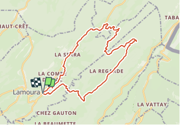
Ruta Senderismo de 21 km a descubrir en Borgoña-Franco Condado, Jura, Lamoura. Esta ruta ha sido propuesta por Le jurassien.
Descripción
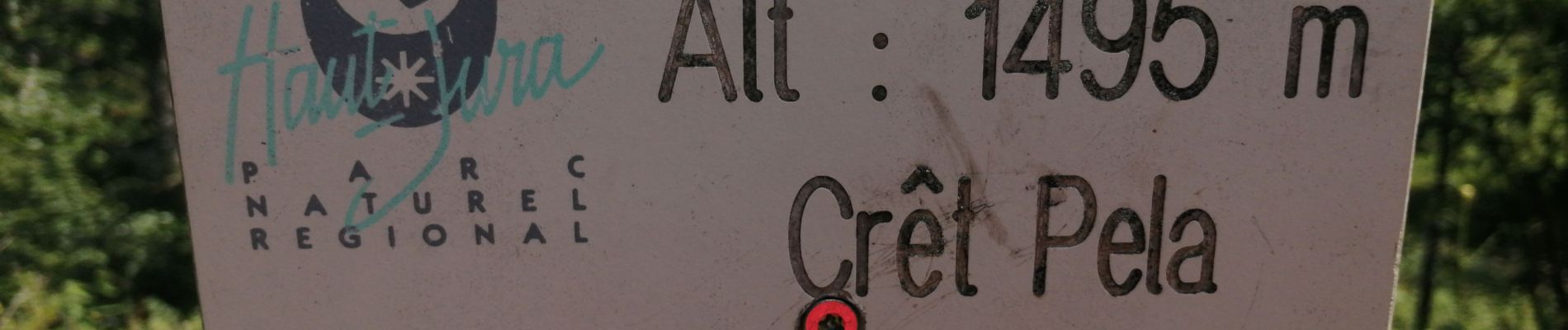
Départ du lac de Lamoura pour la Balise d'amont, la pièce d'aval, la Regarde, le chalet de la Combe, l'épicéa muté, le Crêt Pela 1495m,le chalet de la Frasse et retour au lac de Lamoura.
Localización
País:
France
Región :
Borgoña-Franco Condado
Departamento/provincia :
Jura
Municipio :
Lamoura
Localidad:
Unknown
Salida:(Dec)
Salida:(UTM)
729002 ; 5142184 (31T) N.
Comentarios
Excursiones cerca
![Excursión Senderismo Lamoura - Tresberruy - Lamoura - Photo](https://media.geolcdn.com/t/375/260/ext.jpg?maxdim=2&url=https%3A%2F%2Fservices.sitytrail.com%2FGeolivesWS%2FDownloadMedia.ashx%3FTrailID%3D191503%26Media%3D15097_5.jpg)
![Senderismo Senderismo](https://static1.geolcdn.com/sitytour/trail-icons/101.png)
Tresberruy - Lamoura
Senderismo
Difícil
(1)
Lamoura,
Borgoña-Franco Condado,
Jura,
France
![](/images/other/stat-length.png)
14,5 km | 20 km-effort
4h 0min
![](https://static1.geolcdn.com/siteimages/upload/files/16400158638029165_repeat_loop_refresh_sync_direction_icon.png)
Sí
![Excursión Bicicleta Lajoux - 2023-08-18_15h23m20_lamoura - Photo](https://media.geolcdn.com/t/375/260/ext.jpg?maxdim=2&url=https%3A%2F%2Fstatic1.geolcdn.com%2Fsiteimages%2Fupload%2Ffiles%2F1524743154velo.jpg)
![Bicicleta Bicicleta](https://static1.geolcdn.com/sitytour/trail-icons/200.png)
2023-08-18_15h23m20_lamoura
Bicicleta
Muy fácil
(1)
Lajoux,
Borgoña-Franco Condado,
Jura,
France
![](/images/other/stat-length.png)
21 km | 26 km-effort
Desconocido
![](https://static1.geolcdn.com/siteimages/upload/files/16400158638029165_repeat_loop_refresh_sync_direction_icon.png)
Sí
![Excursión Carrera Mijoux - UTTJ 2015-2 - Photo](https://media.geolcdn.com/t/375/260/ext.jpg?maxdim=2&url=https%3A%2F%2Fstatic1.geolcdn.com%2Fsiteimages%2Fupload%2Ffiles%2F1524743154running.jpg)
![Carrera Carrera](https://static1.geolcdn.com/sitytour/trail-icons/103.png)
UTTJ 2015-2
Carrera
Muy difícil
(1)
Mijoux,
Auvergne-Rhône-Alpes,
Ain,
France
![](/images/other/stat-length.png)
57 km | 92 km-effort
18h 13min
![](https://static1.geolcdn.com/siteimages/upload/files/16400158638029165_repeat_loop_refresh_sync_direction_icon.png)
No
![Excursión Senderismo Lajoux - crêt vigoureuse - Photo](https://media.geolcdn.com/t/375/260/ext.jpg?maxdim=2&url=https%3A%2F%2Fmedia.geolcdn.com%2Ff%2F621ceada-b70a-4736-ab71-b2ed77e63872.jpg)
![Senderismo Senderismo](https://static1.geolcdn.com/sitytour/trail-icons/101.png)
crêt vigoureuse
Senderismo
Medio
Lajoux,
Borgoña-Franco Condado,
Jura,
France
![](/images/other/stat-length.png)
12,3 km | 16,8 km-effort
5h 0min
![](https://static1.geolcdn.com/siteimages/upload/files/16400158638029165_repeat_loop_refresh_sync_direction_icon.png)
Sí
![Excursión Senderismo Gex - Balade à Col de la Faucille, Gex - Photo](https://media.geolcdn.com/t/375/260/ext.jpg?maxdim=2&url=https%3A%2F%2Fmedia.geolcdn.com%2Ff%2F2f44fa08-e5b7-4e3a-aeb8-a26203de0478.jpg)
![Senderismo Senderismo](https://static1.geolcdn.com/sitytour/trail-icons/101.png)
Balade à Col de la Faucille, Gex
Senderismo
Muy difícil
Gex,
Auvergne-Rhône-Alpes,
Ain,
France
![](/images/other/stat-length.png)
86 km | 135 km-effort
9h 23min
![](https://static1.geolcdn.com/siteimages/upload/files/16400158638029165_repeat_loop_refresh_sync_direction_icon.png)
No
![Excursión Cicloturismo Mijoux - LES ROUSSES - COL DE LA FAUCILLE - Photo](https://media.geolcdn.com/t/375/260/ext.jpg?maxdim=2&url=https%3A%2F%2Fmedia.geolcdn.com%2Ff%2F8bcbda14-9a90-4870-91bc-b4b02ae26659.jpg)
![Cicloturismo Cicloturismo](https://static1.geolcdn.com/sitytour/trail-icons/204.png)
LES ROUSSES - COL DE LA FAUCILLE
Cicloturismo
Muy difícil
Mijoux,
Auvergne-Rhône-Alpes,
Ain,
France
![](/images/other/stat-length.png)
54 km | 68 km-effort
4h 57min
![](https://static1.geolcdn.com/siteimages/upload/files/16400158638029165_repeat_loop_refresh_sync_direction_icon.png)
No
![Excursión Senderismo Lamoura - Autour Lamoura - Photo](https://media.geolcdn.com/t/375/260/ext.jpg?maxdim=2&url=https%3A%2F%2Fmedia.geolcdn.com%2Ff%2F4d2d444f-1c9a-4eba-b912-3979cf888d2a.jpg)
![Senderismo Senderismo](https://static1.geolcdn.com/sitytour/trail-icons/101.png)
Autour Lamoura
Senderismo
Medio
Lamoura,
Borgoña-Franco Condado,
Jura,
France
![](/images/other/stat-length.png)
17,1 km | 25 km-effort
4h 37min
![](https://static1.geolcdn.com/siteimages/upload/files/16400158638029165_repeat_loop_refresh_sync_direction_icon.png)
Sí
![Excursión Raquetas de nieve Lamoura - Lamoura 14km D+ 493 20210228 - Photo](https://media.geolcdn.com/t/375/260/ext.jpg?maxdim=2&url=https%3A%2F%2Fmedia.geolcdn.com%2Ff%2F35018357-db62-4969-b1eb-44746be9c2ce.jpg)
![Raquetas de nieve Raquetas de nieve](https://static1.geolcdn.com/sitytour/trail-icons/504.png)
Lamoura 14km D+ 493 20210228
Raquetas de nieve
Muy fácil
Lamoura,
Borgoña-Franco Condado,
Jura,
France
![](/images/other/stat-length.png)
14 km | 21 km-effort
3h 36min
![](https://static1.geolcdn.com/siteimages/upload/files/16400158638029165_repeat_loop_refresh_sync_direction_icon.png)
Sí
![Excursión Senderismo Gex - la faucille - montrond - Photo](https://media.geolcdn.com/t/375/260/ext.jpg?maxdim=2&url=https%3A%2F%2Fmedia.geolcdn.com%2Ff%2F1881b861-b688-4c87-969b-01b7e35c8667.jpg)
![Senderismo Senderismo](https://static1.geolcdn.com/sitytour/trail-icons/101.png)
la faucille - montrond
Senderismo
Medio
Gex,
Auvergne-Rhône-Alpes,
Ain,
France
![](/images/other/stat-length.png)
12,4 km | 22 km-effort
1h 35min
![](https://static1.geolcdn.com/siteimages/upload/files/16400158638029165_repeat_loop_refresh_sync_direction_icon.png)
No