![](/images/other/stat-length.png)
![Excursión Senderismo Le Castellard-Mélan - Auribeau depuis Melan - Photo](https://media.geolcdn.com/t/1900/400/e2744e9a-503d-47ec-88d4-b212681b0e6b.jpg&format=pjpeg&maxdim=2)
Auribeau depuis Melan
jalien04
Usuario
![Longitud](/images/other/stat-length.png)
![Altitud máxima](https://static1.geolcdn.com/siteimages/upload/files/1508320355ic_sort_altitude_max_24dp.png)
![Desnivel positivo](https://static1.geolcdn.com/siteimages/upload/files/1508320355ic_sort_den_pos_24dp.png)
![Km-Effort](/images/other/stat-length.png)
![Altitud mínima](https://static1.geolcdn.com/siteimages/upload/files/1508320355ic_sort_altitude_min_24dp.png)
![Desnivel negativo](https://static1.geolcdn.com/siteimages/upload/files/1508320355ic_sort_den_neg_24dp.png)
![Boucle](https://static1.geolcdn.com/siteimages/upload/files/16400158638029165_repeat_loop_refresh_sync_direction_icon.png)
![Senderismo](https://static1.geolcdn.com/sitytour/trail-icons/101.png)
3h48
Dificultad : Medio
![Escanee este código QR para abrir la excursión en la aplicación SityTrail](https://capi.geolives.com/qq0zvz2zws4bq2lad0pu/sitytour/trails/2867621/qr.png?size=200)
Aplicación GPS de excursión GRATIS
A propósito
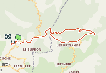
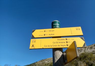
Ruta Senderismo de 11,1 km a descubrir en Provenza-Alpes-Costa Azul, Alpes de Alta Provenza, Le Castellard-Mélan. Esta ruta ha sido propuesta por jalien04.
Descripción
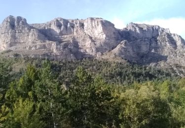
A la sortie de Mélan, suivre le sentier en contrebas de la route, 700m, 200m de route jusqu'au sentier en aval du col de l'hysope vers le ravin du Bramefan, effectuer le tour de la roche des Brigands qui vous mène à Auribeau. Ancien château, église et cimetière. Retour par le même chemin depuis les vallons de Bramefan et de Chabretière (en provenance du col de Fontbelle)
Localización
Comentarios
Excursiones cerca
![Excursión Senderismo Saint-Geniez - S GENIEZ . ABROS . LA FOREST . COL DE MOUNIS . O L M - Photo](https://media.geolcdn.com/t/375/260/fe9f057e-508d-4bc4-89fa-aff1c37055dd.jpg&format=jpg&maxdim=2)
![Senderismo Senderismo](https://static1.geolcdn.com/sitytour/trail-icons/101.png)
Senderismo
![](/images/other/stat-length.png)
![](https://static1.geolcdn.com/siteimages/upload/files/16400158638029165_repeat_loop_refresh_sync_direction_icon.png)
![Excursión Senderismo Hautes-Duyes - geruen sentier des chamois - Photo](https://media.geolcdn.com/t/375/260/76e6f18d-9f19-4351-821e-ec84b6202ed5.jpg&format=jpg&maxdim=2)
![Senderismo Senderismo](https://static1.geolcdn.com/sitytour/trail-icons/101.png)
Senderismo
![](/images/other/stat-length.png)
![](https://static1.geolcdn.com/siteimages/upload/files/16400158638029165_repeat_loop_refresh_sync_direction_icon.png)
![Excursión Senderismo Le Castellard-Mélan - MELAN . Col de Mounis , sommet du Corbeau o l s - Photo](https://media.geolcdn.com/t/375/260/2b656901-381a-4dfe-a9e9-2df9166addba.jpg&format=jpg&maxdim=2)
![Senderismo Senderismo](https://static1.geolcdn.com/sitytour/trail-icons/101.png)
Senderismo
![](/images/other/stat-length.png)
![](https://static1.geolcdn.com/siteimages/upload/files/16400158638029165_repeat_loop_refresh_sync_direction_icon.png)
![Excursión Senderismo Authon - AUTHON Faissal La Croix de Vey ré Sommet de Chine o - Photo](https://media.geolcdn.com/t/375/260/ext.jpg?maxdim=2&url=https%3A%2F%2Fstatic1.geolcdn.com%2Fsiteimages%2Fupload%2Ffiles%2F1553511878bg_sport_marche.png)
![Senderismo Senderismo](https://static1.geolcdn.com/sitytour/trail-icons/101.png)
Senderismo
![](/images/other/stat-length.png)
![](https://static1.geolcdn.com/siteimages/upload/files/16400158638029165_repeat_loop_refresh_sync_direction_icon.png)
![Excursión Senderismo Le Castellard-Mélan - Autour de Fontbelle 18/12/2024 - Photo](https://media.geolcdn.com/t/375/260/69b9121f-8e6a-46ef-affd-f6d0486b57b2.jpg&format=jpg&maxdim=2)
![Senderismo Senderismo](https://static1.geolcdn.com/sitytour/trail-icons/101.png)
Senderismo
![](/images/other/stat-length.png)
![](https://static1.geolcdn.com/siteimages/upload/files/16400158638029165_repeat_loop_refresh_sync_direction_icon.png)
![Excursión Senderismo Authon - AUTHON. GROTTE. COL DE L AIGUILLE O L - Photo](https://media.geolcdn.com/t/375/260/ddbf7ae4-52a3-4044-bf29-d39533b6071a.jpg&format=jpg&maxdim=2)
![Senderismo Senderismo](https://static1.geolcdn.com/sitytour/trail-icons/101.png)
Senderismo
![](/images/other/stat-length.png)
![](https://static1.geolcdn.com/siteimages/upload/files/16400158638029165_repeat_loop_refresh_sync_direction_icon.png)
![Excursión Senderismo Authon - AUTHON . FAISSAL .LES MONGES . LA CROIX DE VEYRE O L M - Photo](https://media.geolcdn.com/t/375/260/37444576-1d8a-41eb-baa4-0ccab1de4208.jpg&format=jpg&maxdim=2)
![Senderismo Senderismo](https://static1.geolcdn.com/sitytour/trail-icons/101.png)
Senderismo
![](/images/other/stat-length.png)
![](https://static1.geolcdn.com/siteimages/upload/files/16400158638029165_repeat_loop_refresh_sync_direction_icon.png)
![Excursión Senderismo Hautes-Duyes - Crête de Géruën descente sud Est - Photo](https://media.geolcdn.com/t/375/260/896db46e-982b-48f6-bf8f-c5ab98c282d0.jpg&format=jpg&maxdim=2)
![Senderismo Senderismo](https://static1.geolcdn.com/sitytour/trail-icons/101.png)
Senderismo
![](/images/other/stat-length.png)
![](https://static1.geolcdn.com/siteimages/upload/files/16400158638029165_repeat_loop_refresh_sync_direction_icon.png)
![Excursión Senderismo Hautes-Duyes - sommet Geruen et son pas - Photo](https://media.geolcdn.com/t/375/260/3f9beb02-93ed-438f-917d-d2a6ab1524ae.jpg&format=jpg&maxdim=2)
![Senderismo Senderismo](https://static1.geolcdn.com/sitytour/trail-icons/101.png)
Senderismo
![](/images/other/stat-length.png)
![](https://static1.geolcdn.com/siteimages/upload/files/16400158638029165_repeat_loop_refresh_sync_direction_icon.png)