![](/images/other/stat-length.png)
![Excursión Senderismo Sumène - Pinoch - Le Castanet en boucle - Photo](https://media.geolcdn.com/t/1900/400/bd5064d4-29b9-4b43-a546-c0ffd4d19c41.jpg&format=pjpeg&maxdim=2)
Pinoch - Le Castanet en boucle
LBarel
Usuario
![Longitud](/images/other/stat-length.png)
![Altitud máxima](https://static1.geolcdn.com/siteimages/upload/files/1508320355ic_sort_altitude_max_24dp.png)
![Desnivel positivo](https://static1.geolcdn.com/siteimages/upload/files/1508320355ic_sort_den_pos_24dp.png)
![Km-Effort](/images/other/stat-length.png)
![Altitud mínima](https://static1.geolcdn.com/siteimages/upload/files/1508320355ic_sort_altitude_min_24dp.png)
![Desnivel negativo](https://static1.geolcdn.com/siteimages/upload/files/1508320355ic_sort_den_neg_24dp.png)
![Boucle](https://static1.geolcdn.com/siteimages/upload/files/16400158638029165_repeat_loop_refresh_sync_direction_icon.png)
![Senderismo](https://static1.geolcdn.com/sitytour/trail-icons/101.png)
1h00
Dificultad : Fácil
![Escanee este código QR para abrir la excursión en la aplicación SityTrail](https://capi.geolives.com/qq0zvz2zws4bq2lad0pu/sitytour/trails/2865362/qr.png?size=200)
Aplicación GPS de excursión GRATIS
A propósito
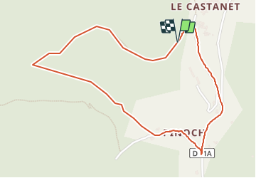
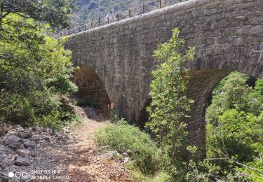
Ruta Senderismo de 2,7 km a descubrir en Occitania, Gard, Sumène. Esta ruta ha sido propuesta por LBarel.
Descripción
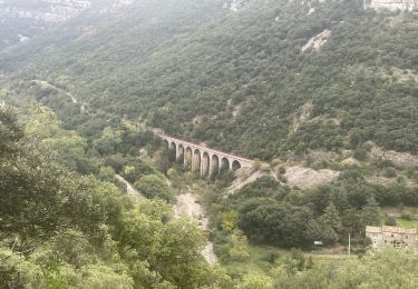
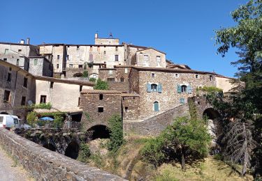
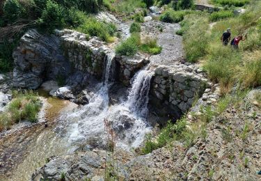
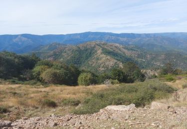
Petite randonnée de 45' qui prend son départ à Pinauch, (contrairement à ce qu'indique le tracé). Se garer dès la bifurcation D11/D11A. Après avoir traversé le hameau sur le GR60, à hauteur de la dernière maison à gauche et juste avant une surface de culture, prendre le sentier qui monte à droite (signe du GR barré). A partir de là une lente montée vers Le Castanet d'où l'on a de belles vues sur la vallée. Du Castanet, descente par la D11.
Localización
Comentarios
Excursiones cerca
![Excursión Senderismo Sumène - Le Ranc de Banes - Sumène - Photo](https://media.geolcdn.com/t/375/260/ext.jpg?maxdim=2&url=https%3A%2F%2Fservices.sitytrail.com%2FGeolivesWS%2FDownloadMedia.ashx%3FTrailID%3D106716%26Media%3D11360_5.jpg)
![Senderismo Senderismo](https://static1.geolcdn.com/sitytour/trail-icons/101.png)
Senderismo
![](/images/other/stat-length.png)
![](https://static1.geolcdn.com/siteimages/upload/files/16400158638029165_repeat_loop_refresh_sync_direction_icon.png)
![Excursión Senderismo Sumène - Ranc de Banes et les Jumeaux - Photo](https://media.geolcdn.com/t/375/260/98f32182-811b-4f0a-9295-196a455ecf2f.jpg&format=jpg&maxdim=2)
![Senderismo Senderismo](https://static1.geolcdn.com/sitytour/trail-icons/101.png)
Senderismo
![](/images/other/stat-length.png)
![](https://static1.geolcdn.com/siteimages/upload/files/16400158638029165_repeat_loop_refresh_sync_direction_icon.png)
![Excursión Senderismo Roquedur - Roquedur - Photo](https://media.geolcdn.com/t/375/260/ext.jpg?maxdim=2&url=https%3A%2F%2Fstatic1.geolcdn.com%2Fsiteimages%2Fupload%2Ffiles%2F1553511878bg_sport_marche.png)
![Senderismo Senderismo](https://static1.geolcdn.com/sitytour/trail-icons/101.png)
![Excursión Senderismo Sumène - Sumene , le pont des chèvres - Photo](https://media.geolcdn.com/t/375/260/ed181aaa-ab94-42d0-bcb4-df9a435a052b.jpg&format=jpg&maxdim=2)
![Senderismo Senderismo](https://static1.geolcdn.com/sitytour/trail-icons/101.png)
Senderismo
![](/images/other/stat-length.png)
![](https://static1.geolcdn.com/siteimages/upload/files/16400158638029165_repeat_loop_refresh_sync_direction_icon.png)
![Excursión Senderismo Saint-Martial - Montagne du Liron au départ de St Martial - Photo](https://media.geolcdn.com/t/375/260/230ffbae-9a5c-40a3-841b-ca21b92f7b5b.jpg&format=jpg&maxdim=2)
![Senderismo Senderismo](https://static1.geolcdn.com/sitytour/trail-icons/101.png)
Senderismo
![](/images/other/stat-length.png)
![](https://static1.geolcdn.com/siteimages/upload/files/16400158638029165_repeat_loop_refresh_sync_direction_icon.png)
![Excursión Senderismo Saint-André-de-Majencoules - Pont d Herault - Photo](https://media.geolcdn.com/t/375/260/d856160b-56dc-4e09-bd64-d026d26891ce.jpg&format=jpg&maxdim=2)
![Senderismo Senderismo](https://static1.geolcdn.com/sitytour/trail-icons/101.png)
Senderismo
![](/images/other/stat-length.png)
![](https://static1.geolcdn.com/siteimages/upload/files/16400158638029165_repeat_loop_refresh_sync_direction_icon.png)
![Excursión Senderismo Saint-André-de-Majencoules - les Hameaux de Pont d'Herault variante - Photo](https://media.geolcdn.com/t/375/260/6b52f0de-e793-4785-b4db-952bd9b70cf6.jpg&format=jpg&maxdim=2)
![Senderismo Senderismo](https://static1.geolcdn.com/sitytour/trail-icons/101.png)
Senderismo
![](/images/other/stat-length.png)
![](https://static1.geolcdn.com/siteimages/upload/files/16400158638029165_repeat_loop_refresh_sync_direction_icon.png)
![Excursión Senderismo Saint-Martial - arsel saint martial - Photo](https://media.geolcdn.com/t/375/260/7eb2b09d-8664-4214-8948-fa1b3d75088d.jpg&format=jpg&maxdim=2)
![Senderismo Senderismo](https://static1.geolcdn.com/sitytour/trail-icons/101.png)
Senderismo
![](/images/other/stat-length.png)
![](https://static1.geolcdn.com/siteimages/upload/files/16400158638029165_repeat_loop_refresh_sync_direction_icon.png)
![Excursión Senderismo Sumène - Sumène - Pont des chèvres - Photo](https://media.geolcdn.com/t/375/260/53a9deb9-2303-4e43-94be-1808f45d5541.jpg&format=jpg&maxdim=2)
![Senderismo Senderismo](https://static1.geolcdn.com/sitytour/trail-icons/101.png)
Senderismo
![](/images/other/stat-length.png)
![](https://static1.geolcdn.com/siteimages/upload/files/16400158638029165_repeat_loop_refresh_sync_direction_icon.png)