![](/images/other/stat-length.png)
![Excursión Léoncel - 2021-07-15_18h15m10_Cirkwi-Forêt_de_Comblezine - Photo](https://media.geolcdn.com/t/1900/400/ext.pjpeg?maxdim=2&url=https%3A%2F%2Fsecurestorage.geolives.com%2Fsitytour%2Ftrail-bg%2Fdefault.jpg)
2021-07-15_18h15m10_Cirkwi-Forêt_de_Comblezine
michar
Usuario
![Longitud](/images/other/stat-length.png)
Longitud
8,7 km
![Altitud máxima](https://static1.geolcdn.com/siteimages/upload/files/1508320355ic_sort_altitude_max_24dp.png)
Altitud máxima
1340 m
![Desnivel positivo](https://static1.geolcdn.com/siteimages/upload/files/1508320355ic_sort_den_pos_24dp.png)
Desnivel positivo
236 m
![Km-Effort](/images/other/stat-length.png)
Km-Effort
11,8 km
![Altitud mínima](https://static1.geolcdn.com/siteimages/upload/files/1508320355ic_sort_altitude_min_24dp.png)
Altitud mínima
1153 m
![Desnivel negativo](https://static1.geolcdn.com/siteimages/upload/files/1508320355ic_sort_den_neg_24dp.png)
Desnivel negativo
240 m
![Boucle](https://static1.geolcdn.com/siteimages/upload/files/16400158638029165_repeat_loop_refresh_sync_direction_icon.png)
Boucle
Sí
Fecha de creación :
2021-07-15 16:15:10.227
Última modificación :
2021-07-15 16:15:15.614
![Escanee este código QR para abrir la excursión en la aplicación SityTrail](https://capi.geolives.com/qq0zvz2zws4bq2lad0pu/sitytour/trails/2861907/qr.png?size=200)
Aplicación GPS de excursión GRATIS
A propósito
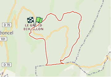
Ruta de 8,7 km a descubrir en Auvergne-Rhône-Alpes, Drôme, Léoncel. Esta ruta ha sido propuesta por michar.
Descripción
Randonnée forestière sur le domaine du Grand Echaillon. L'itinéraire reste principalement en forêt et permet une belle découverte de ce milieu où de nombreuses essences végétales se côtoient.
Localización
País:
France
Región :
Auvergne-Rhône-Alpes
Departamento/provincia :
Drôme
Municipio :
Léoncel
Localidad:
Unknown
Salida:(Dec)
Salida:(UTM)
674358 ; 4975733 (31T) N.
Comentarios
Excursiones cerca
![Excursión Senderismo Omblèze - 2021-07-26_17h20m33_1627312809705_Plateau d_Ambel 15km.gpx.xml - Photo](https://media.geolcdn.com/t/375/260/07e91571-7633-48aa-a91e-19fa46a2d0cc.jpg&format=jpg&maxdim=2)
![Senderismo Senderismo](https://static1.geolcdn.com/sitytour/trail-icons/101.png)
2021-07-26_17h20m33_1627312809705_Plateau d_Ambel 15km.gpx.xml
Senderismo
Muy difícil
(1)
Omblèze,
Auvergne-Rhône-Alpes,
Drôme,
France
![](/images/other/stat-length.png)
14,9 km | 22 km-effort
4h 56min
![](https://static1.geolcdn.com/siteimages/upload/files/16400158638029165_repeat_loop_refresh_sync_direction_icon.png)
Sí
![Excursión Senderismo Le Chaffal - 26 vacherie arches comberoufle - Photo](https://media.geolcdn.com/t/375/260/27ca79a9-2463-4a38-9d47-59fa4758352c.jpg&format=jpg&maxdim=2)
![Senderismo Senderismo](https://static1.geolcdn.com/sitytour/trail-icons/101.png)
26 vacherie arches comberoufle
Senderismo
Fácil
Le Chaffal,
Auvergne-Rhône-Alpes,
Drôme,
France
![](/images/other/stat-length.png)
7,3 km | 12,1 km-effort
3h 25min
![](https://static1.geolcdn.com/siteimages/upload/files/16400158638029165_repeat_loop_refresh_sync_direction_icon.png)
Sí
![Excursión Senderismo Bouvante - 26 bouvante pas ligue st truite - Photo](https://media.geolcdn.com/t/375/260/9494233e-7248-475d-add1-20018e6bbb97.jpg&format=jpg&maxdim=2)
![Senderismo Senderismo](https://static1.geolcdn.com/sitytour/trail-icons/101.png)
26 bouvante pas ligue st truite
Senderismo
Difícil
Bouvante,
Auvergne-Rhône-Alpes,
Drôme,
France
![](/images/other/stat-length.png)
18,7 km | 31 km-effort
8h 42min
![](https://static1.geolcdn.com/siteimages/upload/files/16400158638029165_repeat_loop_refresh_sync_direction_icon.png)
No
![Excursión Senderismo Omblèze - 26 pas de la sausse - Photo](https://media.geolcdn.com/t/375/260/ext.jpg?maxdim=2&url=https%3A%2F%2Fservices.sitytrail.com%2FGeolivesWS%2FDownloadMedia.ashx%3FTrailID%3D472646%26Media%3Dfix__20140403141012.jpg)
![Senderismo Senderismo](https://static1.geolcdn.com/sitytour/trail-icons/101.png)
26 pas de la sausse
Senderismo
Medio
Omblèze,
Auvergne-Rhône-Alpes,
Drôme,
France
![](/images/other/stat-length.png)
12,2 km | 22 km-effort
4h 56min
![](https://static1.geolcdn.com/siteimages/upload/files/16400158638029165_repeat_loop_refresh_sync_direction_icon.png)
No
![Excursión Senderismo Léoncel - les roches de treillaras - Photo](https://media.geolcdn.com/t/375/260/ext.jpg?maxdim=2&url=https%3A%2F%2Fstatic1.geolcdn.com%2Fsiteimages%2Fupload%2Ffiles%2F1553511878bg_sport_marche.png)
![Senderismo Senderismo](https://static1.geolcdn.com/sitytour/trail-icons/101.png)
les roches de treillaras
Senderismo
Fácil
(3)
Léoncel,
Auvergne-Rhône-Alpes,
Drôme,
France
![](/images/other/stat-length.png)
11 km | 16 km-effort
2h 14min
![](https://static1.geolcdn.com/siteimages/upload/files/16400158638029165_repeat_loop_refresh_sync_direction_icon.png)
No
![Excursión Senderismo Léoncel - Rando Pas du touet -rocher de la drayette - Photo](https://media.geolcdn.com/t/375/260/ext.jpg?maxdim=2&url=https%3A%2F%2Fstatic1.geolcdn.com%2Fsiteimages%2Fupload%2Ffiles%2F1553511878bg_sport_marche.png)
![Senderismo Senderismo](https://static1.geolcdn.com/sitytour/trail-icons/101.png)
Rando Pas du touet -rocher de la drayette
Senderismo
Fácil
(3)
Léoncel,
Auvergne-Rhône-Alpes,
Drôme,
France
![](/images/other/stat-length.png)
6,3 km | 8,8 km-effort
2h 11min
![](https://static1.geolcdn.com/siteimages/upload/files/16400158638029165_repeat_loop_refresh_sync_direction_icon.png)
Sí
![Excursión Senderismo Léoncel - Pierre Chauve depuis le Col de Tourniol - Photo](https://media.geolcdn.com/t/375/260/ext.jpg?maxdim=2&url=https%3A%2F%2Fstatic1.geolcdn.com%2Fsiteimages%2Fupload%2Ffiles%2F1553511878bg_sport_marche.png)
![Senderismo Senderismo](https://static1.geolcdn.com/sitytour/trail-icons/101.png)
Pierre Chauve depuis le Col de Tourniol
Senderismo
Fácil
(3)
Léoncel,
Auvergne-Rhône-Alpes,
Drôme,
France
![](/images/other/stat-length.png)
7,9 km | 12,3 km-effort
2h 52min
![](https://static1.geolcdn.com/siteimages/upload/files/16400158638029165_repeat_loop_refresh_sync_direction_icon.png)
Sí
![Excursión Bici de montaña Léoncel - Tête de la Dame - Photo](https://media.geolcdn.com/t/375/260/ext.jpg?maxdim=2&url=https%3A%2F%2Fstatic1.geolcdn.com%2Fsiteimages%2Fupload%2Ffiles%2F1524743154velo.jpg)
![Bici de montaña Bici de montaña](https://static1.geolcdn.com/sitytour/trail-icons/202.png)
Tête de la Dame
Bici de montaña
Medio
(1)
Léoncel,
Auvergne-Rhône-Alpes,
Drôme,
France
![](/images/other/stat-length.png)
27 km | 39 km-effort
2h 35min
![](https://static1.geolcdn.com/siteimages/upload/files/16400158638029165_repeat_loop_refresh_sync_direction_icon.png)
Sí
![Excursión Senderismo Barbières - 26 pierre chauve barbieres zel - Photo](https://media.geolcdn.com/t/375/260/92caf138-cce3-4645-835e-f3491e5ff577.jpg&format=jpg&maxdim=2)
![Senderismo Senderismo](https://static1.geolcdn.com/sitytour/trail-icons/101.png)
26 pierre chauve barbieres zel
Senderismo
Medio
Barbières,
Auvergne-Rhône-Alpes,
Drôme,
France
![](/images/other/stat-length.png)
13,8 km | 26 km-effort
7h 9min
![](https://static1.geolcdn.com/siteimages/upload/files/16400158638029165_repeat_loop_refresh_sync_direction_icon.png)
No