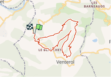
![](/images/other/stat-length.png)
![Excursión Senderismo Venterol - Boucle par la crête de la Cuérate - Venterol - Photo](https://media.geolcdn.com/t/1900/400/ext.pjpeg?maxdim=2&url=https%3A%2F%2Fstatic1.geolcdn.com%2Fsiteimages%2Fupload%2Ffiles%2F1553511878bg_sport_marche.png)
Boucle par la crête de la Cuérate - Venterol
rigol05
Usuario
![Longitud](/images/other/stat-length.png)
![Altitud máxima](https://static1.geolcdn.com/siteimages/upload/files/1508320355ic_sort_altitude_max_24dp.png)
![Desnivel positivo](https://static1.geolcdn.com/siteimages/upload/files/1508320355ic_sort_den_pos_24dp.png)
![Km-Effort](/images/other/stat-length.png)
![Altitud mínima](https://static1.geolcdn.com/siteimages/upload/files/1508320355ic_sort_altitude_min_24dp.png)
![Desnivel negativo](https://static1.geolcdn.com/siteimages/upload/files/1508320355ic_sort_den_neg_24dp.png)
![Boucle](https://static1.geolcdn.com/siteimages/upload/files/16400158638029165_repeat_loop_refresh_sync_direction_icon.png)
![Senderismo](https://static1.geolcdn.com/sitytour/trail-icons/101.png)
3h35
Dificultad : Medio
![Escanee este código QR para abrir la excursión en la aplicación SityTrail](https://capi.geolives.com/qq0zvz2zws4bq2lad0pu/sitytour/trails/2858423/qr.png?size=200)
Aplicación GPS de excursión GRATIS
A propósito
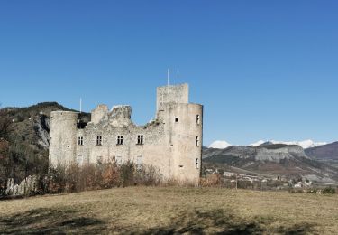
Ruta Senderismo de 11 km a descubrir en Provenza-Alpes-Costa Azul, Alpes de Alta Provenza, Venterol. Esta ruta ha sido propuesta por rigol05.
Descripción
Sortie du 12-07 départ D854 au niveau de la table d'orientation.
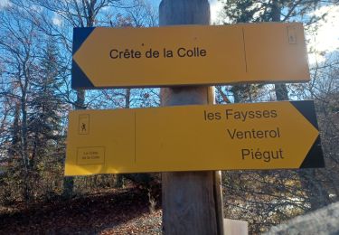
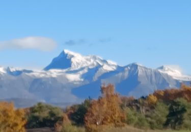
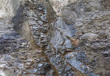
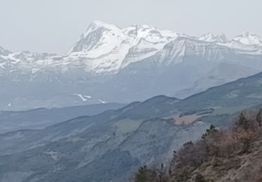
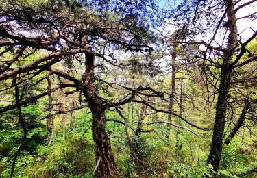
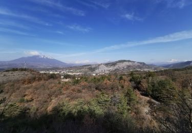
Itinéraire sur route, piste, chemin, sentier, il est dommage que par endroit la végétation encombre le passage. Le tour de la Cuérate offre de beaux paysages. Le passage du ravin des Blaches bien qu'aménagé peut s'avérer délicat pour certains. Aucun balisage sur l'itinéraire, une trace gps est recommandée.
Localización
Comentarios
Excursiones cerca
![Excursión Senderismo Venterol - URTIS . COL DE BUISSONET . SOM DE MONTSERIEUX . VENTEROL . O M S - Photo](https://media.geolcdn.com/t/375/260/66ad6ab3-2755-42db-980f-eb6a39873af4.jpg&format=jpg&maxdim=2)
![Senderismo Senderismo](https://static1.geolcdn.com/sitytour/trail-icons/101.png)
Senderismo
![](/images/other/stat-length.png)
![](https://static1.geolcdn.com/siteimages/upload/files/16400158638029165_repeat_loop_refresh_sync_direction_icon.png)
![Excursión Senderismo Jarjayes - VALSAIRES CHAPELLE NOTRE DAME DU LAIS - Photo](https://media.geolcdn.com/t/375/260/860e51d5-4111-42e4-9649-8920f6056baf.jpg&format=jpg&maxdim=2)
![Senderismo Senderismo](https://static1.geolcdn.com/sitytour/trail-icons/101.png)
Senderismo
![](/images/other/stat-length.png)
![](https://static1.geolcdn.com/siteimages/upload/files/16400158638029165_repeat_loop_refresh_sync_direction_icon.png)
![Excursión Senderismo Châteauvieux - CHATEAUVIEUX . BOIS DE CHRISTAYES LES MARINONS O S - Photo](https://media.geolcdn.com/t/375/260/670230d0-707b-4966-beff-b088375cc2f4.jpg&format=jpg&maxdim=2)
![Senderismo Senderismo](https://static1.geolcdn.com/sitytour/trail-icons/101.png)
Senderismo
![](/images/other/stat-length.png)
![](https://static1.geolcdn.com/siteimages/upload/files/16400158638029165_repeat_loop_refresh_sync_direction_icon.png)
![Excursión Senderismo Tallard - Tallard - les Marinons 17.6.23 - Photo](https://media.geolcdn.com/t/375/260/81bcacf1-1621-4520-bae3-4d5019215e0c.jpg&format=jpg&maxdim=2)
![Senderismo Senderismo](https://static1.geolcdn.com/sitytour/trail-icons/101.png)
Senderismo
![](/images/other/stat-length.png)
![](https://static1.geolcdn.com/siteimages/upload/files/16400158638029165_repeat_loop_refresh_sync_direction_icon.png)
![Excursión Senderismo Tallard - TALLARD tête de Boursier o m s - Photo](https://media.geolcdn.com/t/375/260/ee8e87fe-5cd1-4067-9cf8-9a025ecb47fe.jpg&format=jpg&maxdim=2)
![Senderismo Senderismo](https://static1.geolcdn.com/sitytour/trail-icons/101.png)
Senderismo
![](/images/other/stat-length.png)
![](https://static1.geolcdn.com/siteimages/upload/files/16400158638029165_repeat_loop_refresh_sync_direction_icon.png)
![Excursión Senderismo Piégut - Tour du ravin de Neyrac Via Piégut - Photo](https://media.geolcdn.com/t/375/260/f436686e-fd78-43e7-89bc-7db0374b15b6.jpg&format=jpg&maxdim=2)
![Senderismo Senderismo](https://static1.geolcdn.com/sitytour/trail-icons/101.png)
Senderismo
![](/images/other/stat-length.png)
![](https://static1.geolcdn.com/siteimages/upload/files/16400158638029165_repeat_loop_refresh_sync_direction_icon.png)
![Excursión Senderismo Tallard - Boucle Tallard - Venterol - Photo](https://media.geolcdn.com/t/375/260/d2aca6a7-9b99-4189-94c8-b337d4562050.jpg&format=jpg&maxdim=2)
![Senderismo Senderismo](https://static1.geolcdn.com/sitytour/trail-icons/101.png)
Senderismo
![](/images/other/stat-length.png)
![](https://static1.geolcdn.com/siteimages/upload/files/16400158638029165_repeat_loop_refresh_sync_direction_icon.png)
![Excursión Senderismo Tallard - Tour le long de la Durance et sur les crètes du château - Photo](https://media.geolcdn.com/t/375/260/504184d0-d7c4-4211-be7a-ed4a50921050.jpg&format=jpg&maxdim=2)
![Senderismo Senderismo](https://static1.geolcdn.com/sitytour/trail-icons/101.png)
Senderismo
![](/images/other/stat-length.png)
![](https://static1.geolcdn.com/siteimages/upload/files/16400158638029165_repeat_loop_refresh_sync_direction_icon.png)
![Excursión Senderismo Valserres - Chapelle Saint Maurice. - Photo](https://media.geolcdn.com/t/375/260/0a473682-9b70-4f19-aaa2-260640970212.jpg&format=jpg&maxdim=2)
![Senderismo Senderismo](https://static1.geolcdn.com/sitytour/trail-icons/101.png)
Senderismo
![](/images/other/stat-length.png)
![](https://static1.geolcdn.com/siteimages/upload/files/16400158638029165_repeat_loop_refresh_sync_direction_icon.png)