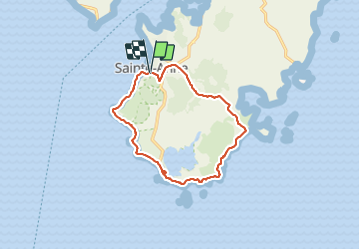
![](/images/other/stat-length.png)
![Excursión Senderismo Sainte-Anne - Grande randonnée sportive. - Photo](https://media.geolcdn.com/t/1900/400/ddf7201d-c88d-499d-92a4-078cc28cb9a7.jpg&format=pjpeg&maxdim=2)
Grande randonnée sportive.
GabyG
Usuario GUIDE
![Longitud](/images/other/stat-length.png)
![Altitud máxima](https://static1.geolcdn.com/siteimages/upload/files/1508320355ic_sort_altitude_max_24dp.png)
![Desnivel positivo](https://static1.geolcdn.com/siteimages/upload/files/1508320355ic_sort_den_pos_24dp.png)
![Km-Effort](/images/other/stat-length.png)
![Altitud mínima](https://static1.geolcdn.com/siteimages/upload/files/1508320355ic_sort_altitude_min_24dp.png)
![Desnivel negativo](https://static1.geolcdn.com/siteimages/upload/files/1508320355ic_sort_den_neg_24dp.png)
![Boucle](https://static1.geolcdn.com/siteimages/upload/files/16400158638029165_repeat_loop_refresh_sync_direction_icon.png)
![Senderismo](https://static1.geolcdn.com/sitytour/trail-icons/101.png)
4h21
Dificultad : Difícil
![Escanee este código QR para abrir la excursión en la aplicación SityTrail](https://capi.geolives.com/qq0zvz2zws4bq2lad0pu/sitytour/trails/2857794/qr.png?size=200)
Aplicación GPS de excursión GRATIS
A propósito
Ruta Senderismo de 17,2 km a descubrir en Martinica, Desconocido, Sainte-Anne. Esta ruta ha sido propuesta por GabyG.
Descripción
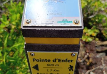
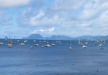
Départ; bourg de St Anne collège, vers Val-D'or, Anse Trabaud, Savane des pétrifications, Pointe des Salines, Observatoire Ormythologique, Petit Anse des Salines, Anse Moustique, Anse Meunier, Pointe Dunkerque, Caritan et Boug de Ste Anne.
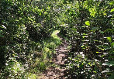
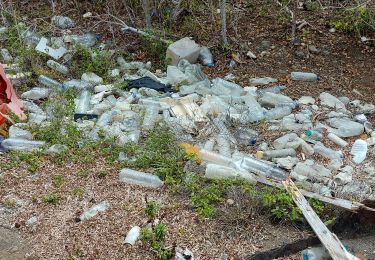
Localización
Comentarios
Excursiones cerca
![Excursión Senderismo Sainte-Anne - du piton crève-coeur vers Le Cap chevalier - Photo](https://media.geolcdn.com/t/375/260/6749dbdc-4c58-4322-bb83-2441fae87cce.jpg&format=jpg&maxdim=2)
![Senderismo Senderismo](https://static1.geolcdn.com/sitytour/trail-icons/101.png)
Senderismo
![](/images/other/stat-length.png)
![](https://static1.geolcdn.com/siteimages/upload/files/16400158638029165_repeat_loop_refresh_sync_direction_icon.png)
![Excursión Senderismo Sainte-Anne - petit Versailles vers cap chevalier. - Photo](https://media.geolcdn.com/t/375/260/80bbb222-4b9d-4e8c-9d73-6683250d106d.jpg&format=jpg&maxdim=2)
![Senderismo Senderismo](https://static1.geolcdn.com/sitytour/trail-icons/101.png)
Senderismo
![](/images/other/stat-length.png)
![](https://static1.geolcdn.com/siteimages/upload/files/16400158638029165_repeat_loop_refresh_sync_direction_icon.png)
![Excursión Senderismo Sainte-Anne - Saline vers la savane des pétrifications. - Photo](https://media.geolcdn.com/t/375/260/c077a181-adff-40b7-bcab-0b3c35a7aaa7.jpg&format=jpg&maxdim=2)
![Senderismo Senderismo](https://static1.geolcdn.com/sitytour/trail-icons/101.png)
Senderismo
![](/images/other/stat-length.png)
![](https://static1.geolcdn.com/siteimages/upload/files/16400158638029165_repeat_loop_refresh_sync_direction_icon.png)
![Excursión Senderismo Sainte-Anne - Savane des Pétrifications 2 - Photo](https://media.geolcdn.com/t/375/260/a365509c-b2bc-4715-8c0c-de82eaafd9b6.jpg&format=jpg&maxdim=2)
![Senderismo Senderismo](https://static1.geolcdn.com/sitytour/trail-icons/101.png)
Senderismo
![](/images/other/stat-length.png)
![](https://static1.geolcdn.com/siteimages/upload/files/16400158638029165_repeat_loop_refresh_sync_direction_icon.png)
![Excursión Senderismo Sainte-Anne - les anglais vers Cap chevalier - Photo](https://media.geolcdn.com/t/375/260/7eb4d2c5-9446-46ff-82ff-b48301e691eb.jpg&format=jpg&maxdim=2)
![Senderismo Senderismo](https://static1.geolcdn.com/sitytour/trail-icons/101.png)
Senderismo
![](/images/other/stat-length.png)
![](https://static1.geolcdn.com/siteimages/upload/files/16400158638029165_repeat_loop_refresh_sync_direction_icon.png)
![Excursión Senderismo Rivière-Pilote - Escapade sur la cote rocheuses de pointe Borgnèse. - Photo](https://media.geolcdn.com/t/375/260/d844497e-dd48-4a75-95e9-00ab38ecc33c.jpg&format=jpg&maxdim=2)
![Senderismo Senderismo](https://static1.geolcdn.com/sitytour/trail-icons/101.png)
Senderismo
![](/images/other/stat-length.png)
![](https://static1.geolcdn.com/siteimages/upload/files/16400158638029165_repeat_loop_refresh_sync_direction_icon.png)
![Excursión Senderismo Le Marin - La grande aventure, pointe borgnes, petite poterie et Anse figuier - Photo](https://media.geolcdn.com/t/375/260/dcc66156-9b48-42e7-9d37-4996c15cca9d.jpg&format=jpg&maxdim=2)
![Senderismo Senderismo](https://static1.geolcdn.com/sitytour/trail-icons/101.png)
Senderismo
![](/images/other/stat-length.png)
![](https://static1.geolcdn.com/siteimages/upload/files/16400158638029165_repeat_loop_refresh_sync_direction_icon.png)
![Excursión Senderismo Sainte-Anne - Bourg de Ste Anne et ses environs - Photo](https://media.geolcdn.com/t/375/260/24db0cc7-98aa-4528-9b4b-d145a33bcb40.jpg&format=jpg&maxdim=2)
![Senderismo Senderismo](https://static1.geolcdn.com/sitytour/trail-icons/101.png)
Senderismo
![](/images/other/stat-length.png)
![](https://static1.geolcdn.com/siteimages/upload/files/16400158638029165_repeat_loop_refresh_sync_direction_icon.png)
![Excursión Senderismo Rivière-Pilote - Anse Figuier - Petite Poterie - Photo](https://media.geolcdn.com/t/375/260/d13c17cb-0195-44ec-9e9f-787363935290.jpg&format=jpg&maxdim=2)
![Senderismo Senderismo](https://static1.geolcdn.com/sitytour/trail-icons/101.png)
Senderismo
![](/images/other/stat-length.png)
![](https://static1.geolcdn.com/siteimages/upload/files/16400158638029165_repeat_loop_refresh_sync_direction_icon.png)