![](/images/other/stat-length.png)
![Excursión Senderismo Ajaccio - sentier des crêtes ajaccio - Photo](https://media.geolcdn.com/t/1900/400/2ec2494d-0ffd-41c4-bf78-d449e4fa0010.jpg&format=pjpeg&maxdim=2)
sentier des crêtes ajaccio
fab0202
Usuario
![Longitud](/images/other/stat-length.png)
Longitud
11,4 km
![Altitud máxima](https://static1.geolcdn.com/siteimages/upload/files/1508320355ic_sort_altitude_max_24dp.png)
Altitud máxima
406 m
![Desnivel positivo](https://static1.geolcdn.com/siteimages/upload/files/1508320355ic_sort_den_pos_24dp.png)
Desnivel positivo
403 m
![Km-Effort](/images/other/stat-length.png)
Km-Effort
16,8 km
![Altitud mínima](https://static1.geolcdn.com/siteimages/upload/files/1508320355ic_sort_altitude_min_24dp.png)
Altitud mínima
76 m
![Desnivel negativo](https://static1.geolcdn.com/siteimages/upload/files/1508320355ic_sort_den_neg_24dp.png)
Desnivel negativo
419 m
![Boucle](https://static1.geolcdn.com/siteimages/upload/files/16400158638029165_repeat_loop_refresh_sync_direction_icon.png)
Boucle
No
Fecha de creación :
2021-06-30 06:12:03.545
Última modificación :
2021-06-30 09:56:29.472
![Senderismo](https://static1.geolcdn.com/sitytour/trail-icons/101.png)
3h09
Dificultad : Fácil
![Escanee este código QR para abrir la excursión en la aplicación SityTrail](https://capi.geolives.com/qq0zvz2zws4bq2lad0pu/sitytour/trails/2844624/qr.png?size=200)
Aplicación GPS de excursión GRATIS
A propósito
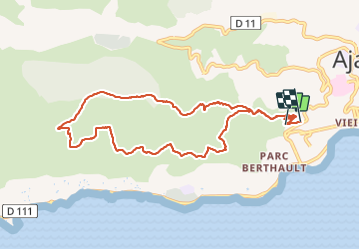
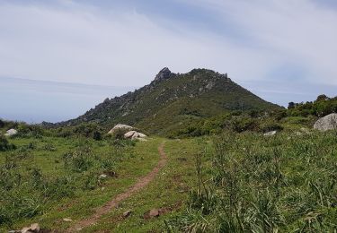
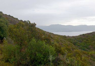
Ruta Senderismo de 11,4 km a descubrir en Córcega, Córcega del Sur, Ajaccio. Esta ruta ha sido propuesta por fab0202.
Descripción
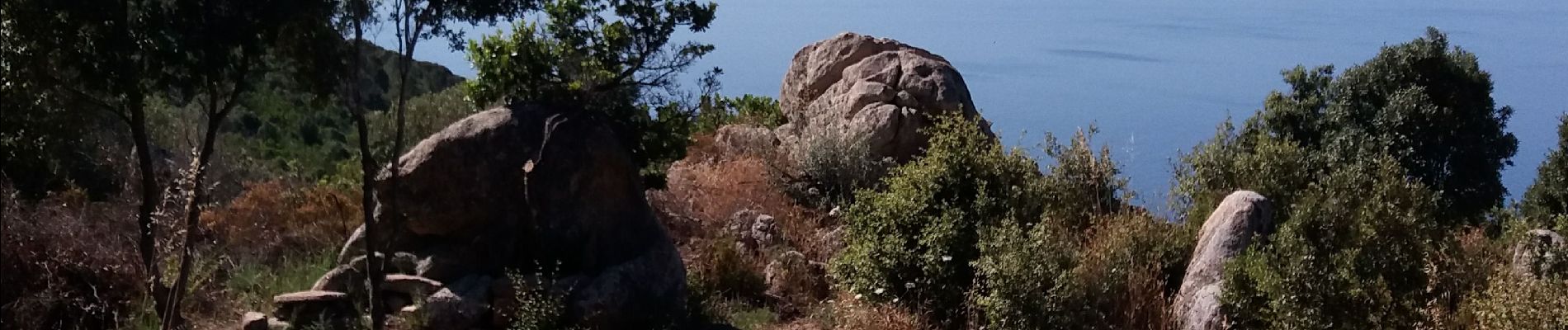
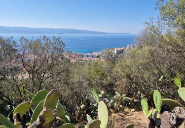
belle rando sur les crêtes avec de beaux points de vue sur le golfe d Ajaccio. A faire tôt le matin car le soleil chauffe
Localización
País:
France
Región :
Córcega
Departamento/provincia :
Córcega del Sur
Municipio :
Ajaccio
Localidad:
Unknown
Salida:(Dec)
Salida:(UTM)
477026 ; 4640709 (32T) N.
Comentarios
Excursiones cerca
![Excursión Senderismo Ajaccio - Ajacio Hôtel Napoléon - Sanguinaires et chemin des douaniers - Photo](https://media.geolcdn.com/t/375/260/38e4b697-8725-4ea3-8b12-a215168ac55d.jpg&format=jpg&maxdim=2)
![Senderismo Senderismo](https://static1.geolcdn.com/sitytour/trail-icons/101.png)
Ajacio Hôtel Napoléon - Sanguinaires et chemin des douaniers
Senderismo
Muy difícil
Ajaccio,
Córcega,
Córcega del Sur,
France
![](/images/other/stat-length.png)
21 km | 25 km-effort
4h 56min
![](https://static1.geolcdn.com/siteimages/upload/files/16400158638029165_repeat_loop_refresh_sync_direction_icon.png)
No
![Excursión Carrera Ajaccio - antennes - Photo](https://media.geolcdn.com/t/375/260/ext.jpg?maxdim=2&url=https%3A%2F%2Fstatic1.geolcdn.com%2Fsiteimages%2Fupload%2Ffiles%2F1524743154running.jpg)
![Carrera Carrera](https://static1.geolcdn.com/sitytour/trail-icons/103.png)
antennes
Carrera
Muy fácil
(1)
Ajaccio,
Córcega,
Córcega del Sur,
France
![](/images/other/stat-length.png)
11,8 km | 15,5 km-effort
1h 9min
![](https://static1.geolcdn.com/siteimages/upload/files/16400158638029165_repeat_loop_refresh_sync_direction_icon.png)
Sí
![Excursión Bicicleta Ajaccio - Boucle lac de Tolla - Photo](https://media.geolcdn.com/t/375/260/ext.jpg?maxdim=2&url=https%3A%2F%2Fstatic1.geolcdn.com%2Fsiteimages%2Fupload%2Ffiles%2F1524743154velo.jpg)
![Bicicleta Bicicleta](https://static1.geolcdn.com/sitytour/trail-icons/200.png)
Boucle lac de Tolla
Bicicleta
Medio
(1)
Ajaccio,
Córcega,
Córcega del Sur,
France
![](/images/other/stat-length.png)
67 km | 85 km-effort
3h 15min
![](https://static1.geolcdn.com/siteimages/upload/files/16400158638029165_repeat_loop_refresh_sync_direction_icon.png)
No
![Excursión Bicicleta Ajaccio - Boucle Massif du Gozzi - Photo](https://media.geolcdn.com/t/375/260/ext.jpg?maxdim=2&url=https%3A%2F%2Fstatic1.geolcdn.com%2Fsiteimages%2Fupload%2Ffiles%2F1524743154velo.jpg)
![Bicicleta Bicicleta](https://static1.geolcdn.com/sitytour/trail-icons/200.png)
Boucle Massif du Gozzi
Bicicleta
Medio
(1)
Ajaccio,
Córcega,
Córcega del Sur,
France
![](/images/other/stat-length.png)
72 km | 90 km-effort
3h 20min
![](https://static1.geolcdn.com/siteimages/upload/files/16400158638029165_repeat_loop_refresh_sync_direction_icon.png)
Sí
![Excursión Senderismo Ajaccio - Ajaccio Le sentier des crêtes - Photo](https://media.geolcdn.com/t/375/260/ext.jpg?maxdim=2&url=https%3A%2F%2Fstatic1.geolcdn.com%2Fsiteimages%2Fupload%2Ffiles%2F1553511878bg_sport_marche.png)
![Senderismo Senderismo](https://static1.geolcdn.com/sitytour/trail-icons/101.png)
Ajaccio Le sentier des crêtes
Senderismo
Medio
(1)
Ajaccio,
Córcega,
Córcega del Sur,
France
![](/images/other/stat-length.png)
10,6 km | 16,1 km-effort
3h 0min
![](https://static1.geolcdn.com/siteimages/upload/files/16400158638029165_repeat_loop_refresh_sync_direction_icon.png)
No
![Excursión A pie Ajaccio - Sentier des Crêtes Ajaccio et Grotte Napoléon - Photo](https://media.geolcdn.com/t/375/260/f2d8e298-11bf-45ac-8185-4e19e2dfbeb9.jpg&format=jpg&maxdim=2)
![A pie A pie](https://static1.geolcdn.com/sitytour/trail-icons/100.png)
Sentier des Crêtes Ajaccio et Grotte Napoléon
A pie
Medio
Ajaccio,
Córcega,
Córcega del Sur,
France
![](/images/other/stat-length.png)
17,4 km | 25 km-effort
5h 41min
![](https://static1.geolcdn.com/siteimages/upload/files/16400158638029165_repeat_loop_refresh_sync_direction_icon.png)
Sí
![Excursión Senderismo Ajaccio - Crète de la punta Lisa Antenne - Photo](https://media.geolcdn.com/t/375/260/bff9218f-ce01-45ff-92c9-f6391512b311.jpg&format=jpg&maxdim=2)
![Senderismo Senderismo](https://static1.geolcdn.com/sitytour/trail-icons/101.png)
Crète de la punta Lisa Antenne
Senderismo
Muy fácil
Ajaccio,
Córcega,
Córcega del Sur,
France
![](/images/other/stat-length.png)
4,9 km | 10 km-effort
2h 48min
![](https://static1.geolcdn.com/siteimages/upload/files/16400158638029165_repeat_loop_refresh_sync_direction_icon.png)
No
![Excursión Senderismo Ajaccio - Corse-151001 - CretesAjaccio - Photo](https://media.geolcdn.com/t/375/260/ext.jpg?maxdim=2&url=https%3A%2F%2Fservices.sitytrail.com%2FGeolivesWS%2FDownloadMedia.ashx%3FTrailID%3D477813%26Media%3D9062a225-b616-4ed5-97af-860714eb3805.jpg)
![Senderismo Senderismo](https://static1.geolcdn.com/sitytour/trail-icons/101.png)
Corse-151001 - CretesAjaccio
Senderismo
Fácil
Ajaccio,
Córcega,
Córcega del Sur,
France
![](/images/other/stat-length.png)
9,9 km | 14,5 km-effort
3h 30min
![](https://static1.geolcdn.com/siteimages/upload/files/16400158638029165_repeat_loop_refresh_sync_direction_icon.png)
Sí
![Excursión Senderismo Ajaccio - sentier des crêtes 18 février 2012 - Photo](https://media.geolcdn.com/t/375/260/ext.jpg?maxdim=2&url=https%3A%2F%2Fstatic1.geolcdn.com%2Fsiteimages%2Fupload%2Ffiles%2F1553511878bg_sport_marche.png)
![Senderismo Senderismo](https://static1.geolcdn.com/sitytour/trail-icons/101.png)
sentier des crêtes 18 février 2012
Senderismo
Fácil
(2)
Ajaccio,
Córcega,
Córcega del Sur,
France
![](/images/other/stat-length.png)
9,2 km | 13,2 km-effort
3h 15min
![](https://static1.geolcdn.com/siteimages/upload/files/16400158638029165_repeat_loop_refresh_sync_direction_icon.png)
Sí