![](/images/other/stat-length.png)
![Excursión Senderismo Somme-Leuze - SINSIN-WAILLET-HOGNE-HUMAIN-SERINCHAMPS-LES BASSES-SINSIN - Photo](https://media.geolcdn.com/t/1900/400/1aca679b-78ad-4fe3-b5b0-81bb648ac2c1.jpg&format=pjpeg&maxdim=2)
SINSIN-WAILLET-HOGNE-HUMAIN-SERINCHAMPS-LES BASSES-SINSIN
JEANMINNE
Usuario
![Longitud](/images/other/stat-length.png)
Longitud
28 km
![Altitud máxima](https://static1.geolcdn.com/siteimages/upload/files/1508320355ic_sort_altitude_max_24dp.png)
Altitud máxima
318 m
![Desnivel positivo](https://static1.geolcdn.com/siteimages/upload/files/1508320355ic_sort_den_pos_24dp.png)
Desnivel positivo
454 m
![Km-Effort](/images/other/stat-length.png)
Km-Effort
34 km
![Altitud mínima](https://static1.geolcdn.com/siteimages/upload/files/1508320355ic_sort_altitude_min_24dp.png)
Altitud mínima
193 m
![Desnivel negativo](https://static1.geolcdn.com/siteimages/upload/files/1508320355ic_sort_den_neg_24dp.png)
Desnivel negativo
455 m
![Boucle](https://static1.geolcdn.com/siteimages/upload/files/16400158638029165_repeat_loop_refresh_sync_direction_icon.png)
Boucle
Sí
Fecha de creación :
2021-06-27 06:19:54.831
Última modificación :
2021-06-27 14:06:10.74
![Senderismo](https://static1.geolcdn.com/sitytour/trail-icons/101.png)
6h52
Dificultad : Medio
![Escanee este código QR para abrir la excursión en la aplicación SityTrail](https://capi.geolives.com/qq0zvz2zws4bq2lad0pu/sitytour/trails/2841377/qr.png?size=200)
Aplicación GPS de excursión GRATIS
A propósito
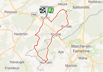
Ruta Senderismo de 28 km a descubrir en Valonia, Namur, Somme-Leuze. Esta ruta ha sido propuesta por JEANMINNE.
Descripción
Sinsin, Sur le Foi, Au Tige, Bois d'heure, Haie Curie,Waillet,Hogne, Bois du Fourneau, Humain, Bois des Deffes, Bois des Dames, Ferme du Moulin, Serinchamps, Le Tomboi, Bois des Carmes, Sacré Cœur, Les Basses, Pont des Ripettes, Sinsin
Localización
País:
Belgium
Región :
Valonia
Departamento/provincia :
Namur
Municipio :
Somme-Leuze
Localidad:
Unknown
Salida:(Dec)
Salida:(UTM)
660864 ; 5571672 (31U) N.
Comentarios
Excursiones cerca
![Excursión Senderismo Hamois - HAMOIS- Scy (Mohiville)- Promenade du Berceau du Bocq - Photo](https://media.geolcdn.com/t/375/260/ext.jpg?maxdim=2&url=https%3A%2F%2Fservices.sitytrail.com%2FGeolivesWS%2FDownloadMedia.ashx%3FTrailID%3D250701%26Media%3D514f4968-57f7-4b3e-aef8-c121b3f2a3eb.jpg)
![Senderismo Senderismo](https://static1.geolcdn.com/sitytour/trail-icons/101.png)
HAMOIS- Scy (Mohiville)- Promenade du Berceau du Bocq
Senderismo
Fácil
(12)
Hamois,
Valonia,
Namur,
Belgium
![](/images/other/stat-length.png)
7,9 km | 9,8 km-effort
2h 4min
![](https://static1.geolcdn.com/siteimages/upload/files/16400158638029165_repeat_loop_refresh_sync_direction_icon.png)
Sí
![Excursión Senderismo Somme-Leuze - RB-Na-04 - Balade aux sources de la Somme - Photo](https://media.geolcdn.com/t/375/260/ext.jpg?maxdim=2&url=https%3A%2F%2Fservices.sitytrail.com%2FGeolivesWS%2FDownloadMedia.ashx%3FTrailID%3D179630%26Media%3D2ccb572a-0d57-4973-8026-20e9cbf116e6.jpg)
![Senderismo Senderismo](https://static1.geolcdn.com/sitytour/trail-icons/101.png)
RB-Na-04 - Balade aux sources de la Somme
Senderismo
Medio
(14)
Somme-Leuze,
Valonia,
Namur,
Belgium
![](/images/other/stat-length.png)
22 km | 28 km-effort
6h 0min
![](https://static1.geolcdn.com/siteimages/upload/files/16400158638029165_repeat_loop_refresh_sync_direction_icon.png)
Sí
![Excursión Senderismo Somme-Leuze - RB-Na-04 Raccourci - Balade aux sources de la Somme - Photo](https://media.geolcdn.com/t/375/260/ext.jpg?maxdim=2&url=https%3A%2F%2Fservices.sitytrail.com%2FGeolivesWS%2FDownloadMedia.ashx%3FTrailID%3D252171%26Media%3Dc5d56e41-95c8-4990-91cc-1ec916893014.jpg)
![Senderismo Senderismo](https://static1.geolcdn.com/sitytour/trail-icons/101.png)
RB-Na-04 Raccourci - Balade aux sources de la Somme
Senderismo
Fácil
(6)
Somme-Leuze,
Valonia,
Namur,
Belgium
![](/images/other/stat-length.png)
18,7 km | 24 km-effort
5h 3min
![](https://static1.geolcdn.com/siteimages/upload/files/16400158638029165_repeat_loop_refresh_sync_direction_icon.png)
Sí
![Excursión A pie Somme-Leuze - Sentiers d'Art : Boucle 17 - Heure - Photo](https://media.geolcdn.com/t/375/260/d3b600c0-617d-4b9c-b782-c930c89e279c.jpg&format=jpg&maxdim=2)
![A pie A pie](https://static1.geolcdn.com/sitytour/trail-icons/100.png)
Sentiers d'Art : Boucle 17 - Heure
A pie
Medio
(2)
Somme-Leuze,
Valonia,
Namur,
Belgium
![](/images/other/stat-length.png)
15,9 km | 20 km-effort
4h 33min
![](https://static1.geolcdn.com/siteimages/upload/files/16400158638029165_repeat_loop_refresh_sync_direction_icon.png)
Sí
![Excursión Senderismo Hamois - La Promenade du Berceau du Bocq - Photo](https://media.geolcdn.com/t/375/260/c1ecebef-4dce-4991-920f-3cf80ab64a6d.jpg&format=jpg&maxdim=2)
![Senderismo Senderismo](https://static1.geolcdn.com/sitytour/trail-icons/101.png)
La Promenade du Berceau du Bocq
Senderismo
Medio
(1)
Hamois,
Valonia,
Namur,
Belgium
![](/images/other/stat-length.png)
9,3 km | 11,2 km-effort
4h 41min
![](https://static1.geolcdn.com/siteimages/upload/files/16400158638029165_repeat_loop_refresh_sync_direction_icon.png)
Sí
![Excursión A pie Ciney - Promenade n° 18 Serinchamps - Photo](https://media.geolcdn.com/t/375/260/ext.jpg?maxdim=2&url=https%3A%2F%2Fpivotmedia.tourismewallonie.be%2FOTH-A0-004L-13IP%2FOTH-A0-004L-13IP.jpg)
![A pie A pie](https://static1.geolcdn.com/sitytour/trail-icons/100.png)
Promenade n° 18 Serinchamps
A pie
Fácil
Ciney,
Valonia,
Namur,
Belgium
![](/images/other/stat-length.png)
5,3 km | 6,8 km-effort
1h 32min
![](https://static1.geolcdn.com/siteimages/upload/files/16400158638029165_repeat_loop_refresh_sync_direction_icon.png)
Sí
![Excursión A pie Hamois - Promenade du Berceau du Bocq - Photo](https://media.geolcdn.com/t/375/260/ext.jpg?maxdim=2&url=https%3A%2F%2Fpivotmedia.tourismewallonie.be%2FOTH-A0-001E-0END%2FOTH-A0-001E-0END.jpg)
![A pie A pie](https://static1.geolcdn.com/sitytour/trail-icons/100.png)
Promenade du Berceau du Bocq
A pie
Fácil
Hamois,
Valonia,
Namur,
Belgium
![](/images/other/stat-length.png)
7,9 km | 9,8 km-effort
2h 13min
![](https://static1.geolcdn.com/siteimages/upload/files/16400158638029165_repeat_loop_refresh_sync_direction_icon.png)
Sí
![Excursión Senderismo Marche-en-Famenne - AYE (Marche-en-Famenne) - Photo](https://media.geolcdn.com/t/375/260/177df7a9-abf7-4969-9175-edee86271467.jpg&format=jpg&maxdim=2)
![Senderismo Senderismo](https://static1.geolcdn.com/sitytour/trail-icons/101.png)
AYE (Marche-en-Famenne)
Senderismo
Medio
Marche-en-Famenne,
Valonia,
Luxemburgo,
Belgium
![](/images/other/stat-length.png)
11 km | 13 km-effort
2h 20min
![](https://static1.geolcdn.com/siteimages/upload/files/16400158638029165_repeat_loop_refresh_sync_direction_icon.png)
Sí
![Excursión A pie Somme-Leuze - Nettinne.. Bob 2020.. - Photo](https://media.geolcdn.com/t/375/260/ext.jpg?maxdim=2&url=https%3A%2F%2Fstatic1.geolcdn.com%2Fsiteimages%2Fupload%2Ffiles%2F1545311037marcheuse_200dpi.jpg)
![A pie A pie](https://static1.geolcdn.com/sitytour/trail-icons/100.png)
Nettinne.. Bob 2020..
A pie
Fácil
(1)
Somme-Leuze,
Valonia,
Namur,
Belgium
![](/images/other/stat-length.png)
10,5 km | 12,9 km-effort
3h 0min
![](https://static1.geolcdn.com/siteimages/upload/files/16400158638029165_repeat_loop_refresh_sync_direction_icon.png)
Sí