![](/images/other/stat-length.png)
![Excursión Senderismo Luzein - Sulzfluh, Rotspitz, Gruobenpass, Partnunsee - Photo](https://media.geolcdn.com/t/1900/400/ext.pjpeg?maxdim=2&url=https%3A%2F%2Fstatic1.geolcdn.com%2Fsiteimages%2Fupload%2Ffiles%2F1553511878bg_sport_marche.png)
Sulzfluh, Rotspitz, Gruobenpass, Partnunsee
perenhout
Usuario
![Longitud](/images/other/stat-length.png)
Longitud
11,2 km
![Altitud máxima](https://static1.geolcdn.com/siteimages/upload/files/1508320355ic_sort_altitude_max_24dp.png)
Altitud máxima
2355 m
![Desnivel positivo](https://static1.geolcdn.com/siteimages/upload/files/1508320355ic_sort_den_pos_24dp.png)
Desnivel positivo
701 m
![Km-Effort](/images/other/stat-length.png)
Km-Effort
21 km
![Altitud mínima](https://static1.geolcdn.com/siteimages/upload/files/1508320355ic_sort_altitude_min_24dp.png)
Altitud mínima
1762 m
![Desnivel negativo](https://static1.geolcdn.com/siteimages/upload/files/1508320355ic_sort_den_neg_24dp.png)
Desnivel negativo
704 m
![Boucle](https://static1.geolcdn.com/siteimages/upload/files/16400158638029165_repeat_loop_refresh_sync_direction_icon.png)
Boucle
Sí
Fecha de creación :
2021-06-25 07:13:31.613
Última modificación :
2021-06-25 13:05:21.783
![Senderismo](https://static1.geolcdn.com/sitytour/trail-icons/101.png)
5h25
Dificultad : Medio
![Escanee este código QR para abrir la excursión en la aplicación SityTrail](https://capi.geolives.com/qq0zvz2zws4bq2lad0pu/sitytour/trails/2838861/qr.png?size=200)
Aplicación GPS de excursión GRATIS
A propósito
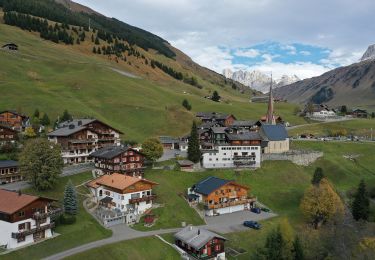
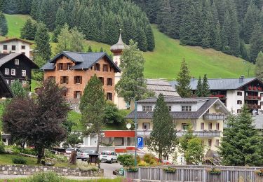
Ruta Senderismo de 11,2 km a descubrir en Grisones, Prättigau/Davos, Luzein. Esta ruta ha sido propuesta por perenhout .
Descripción
Jolie balade Dans le Prättigau, depart de Berghaus Sulzfluh en direstion du Rotspitz. On contourne ensuite la Schijenfluh et la Wiss Platta et on revient en Suisse par le Gruobenpass et Partnunsee.
Localización
País:
Switzerland
Región :
Grisones
Departamento/provincia :
Prättigau/Davos
Municipio :
Luzein
Localidad:
Unknown
Salida:(Dec)
Salida:(UTM)
565323 ; 5204953 (32T) N.
Comentarios
Excursiones cerca
![Excursión A pie Luzein - St. Antönien, Aschüel-Salfsch - Photo](https://media.geolcdn.com/t/375/260/4afa82df-76f0-4480-9a5f-e4358cd61a90.jpeg&format=jpg&maxdim=2)
![A pie A pie](https://static1.geolcdn.com/sitytour/trail-icons/100.png)
St. Antönien, Aschüel-Salfsch
A pie
Fácil
Luzein,
Grisones,
Prättigau/Davos,
Switzerland
![](/images/other/stat-length.png)
5,2 km | 7,4 km-effort
1h 41min
![](https://static1.geolcdn.com/siteimages/upload/files/16400158638029165_repeat_loop_refresh_sync_direction_icon.png)
No
![Excursión A pie Gemeinde Sankt Gallenkirch - Gargellen:Schmugglersroute (PVDB) - Photo](https://media.geolcdn.com/t/375/260/d6049d8e-a6ce-4af0-9bd1-9b2d5daa588c.jpg&format=jpg&maxdim=2)
![A pie A pie](https://static1.geolcdn.com/sitytour/trail-icons/100.png)
Gargellen:Schmugglersroute (PVDB)
A pie
Difícil
Gemeinde Sankt Gallenkirch,
Vorarlberg,
Bezirk Bludenz,
Austria
![](/images/other/stat-length.png)
14,3 km | 24 km-effort
7h 12min
![](https://static1.geolcdn.com/siteimages/upload/files/16400158638029165_repeat_loop_refresh_sync_direction_icon.png)
No
![Excursión Senderismo Luzein - wa17 - Photo](https://media.geolcdn.com/t/375/260/ext.jpg?maxdim=2&url=https%3A%2F%2Fstatic1.geolcdn.com%2Fsiteimages%2Fupload%2Ffiles%2F1553511878bg_sport_marche.png)
![Senderismo Senderismo](https://static1.geolcdn.com/sitytour/trail-icons/101.png)
wa17
Senderismo
Muy fácil
Luzein,
Grisones,
Prättigau/Davos,
Switzerland
![](/images/other/stat-length.png)
12 km | 22 km-effort
Desconocido
![](https://static1.geolcdn.com/siteimages/upload/files/16400158638029165_repeat_loop_refresh_sync_direction_icon.png)
Sí
![Excursión Senderismo Luzein - Partnun - Alpenrundweg - Photo](https://media.geolcdn.com/t/375/260/ext.jpg?maxdim=2&url=https%3A%2F%2Fstatic1.geolcdn.com%2Fsiteimages%2Fupload%2Ffiles%2F1553511878bg_sport_marche.png)
![Senderismo Senderismo](https://static1.geolcdn.com/sitytour/trail-icons/101.png)
Partnun - Alpenrundweg
Senderismo
Muy fácil
Luzein,
Grisones,
Prättigau/Davos,
Switzerland
![](/images/other/stat-length.png)
11 km | 20 km-effort
Desconocido
![](https://static1.geolcdn.com/siteimages/upload/files/16400158638029165_repeat_loop_refresh_sync_direction_icon.png)
Sí
![Excursión Senderismo Luzein - walser_24 - Photo](https://media.geolcdn.com/t/375/260/ext.jpg?maxdim=2&url=https%3A%2F%2Fstatic1.geolcdn.com%2Fsiteimages%2Fupload%2Ffiles%2F1553511878bg_sport_marche.png)
![Senderismo Senderismo](https://static1.geolcdn.com/sitytour/trail-icons/101.png)
walser_24
Senderismo
Muy fácil
Luzein,
Grisones,
Prättigau/Davos,
Switzerland
![](/images/other/stat-length.png)
59 km | 94 km-effort
Desconocido
![](https://static1.geolcdn.com/siteimages/upload/files/16400158638029165_repeat_loop_refresh_sync_direction_icon.png)
No
![Excursión Senderismo Gemeinde Sankt Gallenkirch - YHH091 Schruns à Tirano (1er jour) - Photo](https://media.geolcdn.com/t/375/260/ext.jpg?maxdim=2&url=https%3A%2F%2Fstatic1.geolcdn.com%2Fsiteimages%2Fupload%2Ffiles%2F1553511878bg_sport_marche.png)
![Senderismo Senderismo](https://static1.geolcdn.com/sitytour/trail-icons/101.png)
YHH091 Schruns à Tirano (1er jour)
Senderismo
Muy difícil
Gemeinde Sankt Gallenkirch,
Vorarlberg,
Bezirk Bludenz,
Austria
![](/images/other/stat-length.png)
13,5 km | 26 km-effort
5h 1min
![](https://static1.geolcdn.com/siteimages/upload/files/16400158638029165_repeat_loop_refresh_sync_direction_icon.png)
No
![Excursión Otra actividad Gemeinde Tschagguns - Drusator - Photo](https://media.geolcdn.com/t/375/260/ext.jpg?maxdim=2&url=https%3A%2F%2Fstatic1.geolcdn.com%2Fsiteimages%2Fupload%2Ffiles%2F1545311037marcheuse_200dpi.jpg)
![Otra actividad Otra actividad](https://static1.geolcdn.com/sitytour/trail-icons/900.png)
Drusator
Otra actividad
Muy fácil
Gemeinde Tschagguns,
Vorarlberg,
Bezirk Bludenz,
Austria
![](/images/other/stat-length.png)
12,2 km | 23 km-effort
Desconocido
![](https://static1.geolcdn.com/siteimages/upload/files/16400158638029165_repeat_loop_refresh_sync_direction_icon.png)
No
![Excursión Senderismo Gemeinde Sankt Gallenkirch - 21 09 04 - Photo](https://media.geolcdn.com/t/375/260/ext.jpg?maxdim=2&url=https%3A%2F%2Fstatic1.geolcdn.com%2Fsiteimages%2Fupload%2Ffiles%2F1553511878bg_sport_marche.png)
![Senderismo Senderismo](https://static1.geolcdn.com/sitytour/trail-icons/101.png)
21 09 04
Senderismo
Fácil
Gemeinde Sankt Gallenkirch,
Vorarlberg,
Bezirk Bludenz,
Austria
![](/images/other/stat-length.png)
3,8 km | 6 km-effort
1h 6min
![](https://static1.geolcdn.com/siteimages/upload/files/16400158638029165_repeat_loop_refresh_sync_direction_icon.png)
No