![](/images/other/stat-length.png)
![Excursión Senderismo Eijsden-Margraten - 2021-06-19_19h26m43_031 - Photo](https://media.geolcdn.com/t/1900/400/136c3226-85ca-4638-b449-da2a119d703c.jpg&format=pjpeg&maxdim=2)
2021-06-19_19h26m43_031
mumu.larandonneuse
Usuario GUIDE
![Longitud](/images/other/stat-length.png)
Longitud
13,3 km
![Altitud máxima](https://static1.geolcdn.com/siteimages/upload/files/1508320355ic_sort_altitude_max_24dp.png)
Altitud máxima
186 m
![Desnivel positivo](https://static1.geolcdn.com/siteimages/upload/files/1508320355ic_sort_den_pos_24dp.png)
Desnivel positivo
180 m
![Km-Effort](/images/other/stat-length.png)
Km-Effort
15,7 km
![Altitud mínima](https://static1.geolcdn.com/siteimages/upload/files/1508320355ic_sort_altitude_min_24dp.png)
Altitud mínima
105 m
![Desnivel negativo](https://static1.geolcdn.com/siteimages/upload/files/1508320355ic_sort_den_neg_24dp.png)
Desnivel negativo
180 m
![Boucle](https://static1.geolcdn.com/siteimages/upload/files/16400158638029165_repeat_loop_refresh_sync_direction_icon.png)
Boucle
Sí
Fecha de creación :
2021-06-19 17:26:43.161
Última modificación :
2021-06-20 12:37:52.079
![Senderismo](https://static1.geolcdn.com/sitytour/trail-icons/101.png)
3h34
Dificultad : Fácil
![Escanee este código QR para abrir la excursión en la aplicación SityTrail](https://capi.geolives.com/qq0zvz2zws4bq2lad0pu/sitytour/trails/2832499/qr.png?size=200)
Aplicación GPS de excursión GRATIS
A propósito
Ruta Senderismo de 13,3 km a descubrir en Limburgo, Desconocido, Eijsden-Margraten. Esta ruta ha sido propuesta por mumu.larandonneuse.
Descripción
Belle randonnée dans le Zuid-Limburg.
ℹ Gpx pris de www.wandelgidszuidlimburg.com, rando n° 31.
Localización
País:
Netherlands
Región :
Limburgo
Departamento/provincia :
Desconocido
Municipio :
Eijsden-Margraten
Localidad:
Unknown
Salida:(Dec)
Salida:(UTM)
698021 ; 5630231 (31U) N.
Comentarios
Excursiones cerca
![Excursión Senderismo Eijsden-Margraten - Gulpen - Hubertusmarkt - Photo](https://media.geolcdn.com/t/375/260/6a2a5595-eb93-4f0f-8c09-6c6ead7a7201.jpg&format=jpg&maxdim=2)
![Senderismo Senderismo](https://static1.geolcdn.com/sitytour/trail-icons/101.png)
Gulpen - Hubertusmarkt
Senderismo
Medio
(1)
Eijsden-Margraten,
Limburgo,
Desconocido,
Netherlands
![](/images/other/stat-length.png)
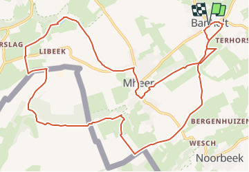
11,5 km | 13,3 km-effort
3h 1min
![](https://static1.geolcdn.com/siteimages/upload/files/16400158638029165_repeat_loop_refresh_sync_direction_icon.png)
Sí
![Excursión Senderismo Eijsden-Margraten - 2024-07-15_17h32m47_eijsden-margraten-mh1-altenbroek - Photo](https://media.geolcdn.com/t/375/260/1dd6d074-f00f-48cf-a4e6-d95117778ebf.jpg&format=jpg&maxdim=2)
![Senderismo Senderismo](https://static1.geolcdn.com/sitytour/trail-icons/101.png)
2024-07-15_17h32m47_eijsden-margraten-mh1-altenbroek
Senderismo
Medio
(1)
Eijsden-Margraten,
Limburgo,
Desconocido,
Netherlands
![](/images/other/stat-length.png)
8,8 km | 11 km-effort
2h 29min
![](https://static1.geolcdn.com/siteimages/upload/files/16400158638029165_repeat_loop_refresh_sync_direction_icon.png)
Sí
![Excursión Senderismo Eijsden-Margraten - Mheer - Banholt - Hoogbos - Photo](https://media.geolcdn.com/t/375/260/1f70cdf1-9a0b-4d25-acc7-7c75993bbb86.jpg&format=jpg&maxdim=2)
![Senderismo Senderismo](https://static1.geolcdn.com/sitytour/trail-icons/101.png)
Mheer - Banholt - Hoogbos
Senderismo
Medio
(1)
Eijsden-Margraten,
Limburgo,
Desconocido,
Netherlands
![](/images/other/stat-length.png)
12,5 km | 14,5 km-effort
3h 4min
![](https://static1.geolcdn.com/siteimages/upload/files/16400158638029165_repeat_loop_refresh_sync_direction_icon.png)
Sí
![Excursión Senderismo Voeren - Amstel Gold Race 2024 🚲 - Photo](https://media.geolcdn.com/t/375/260/bca146f7-0c03-4970-a3ca-ea328283e994.jpg&format=jpg&maxdim=2)
![Senderismo Senderismo](https://static1.geolcdn.com/sitytour/trail-icons/101.png)
Amstel Gold Race 2024 🚲
Senderismo
Medio
(1)
Voeren,
Flandes,
Limburgo,
Belgium
![](/images/other/stat-length.png)
11,7 km | 14,9 km-effort
3h 23min
![](https://static1.geolcdn.com/siteimages/upload/files/16400158638029165_repeat_loop_refresh_sync_direction_icon.png)
Sí
![Excursión Senderismo Voeren - Ulvend - La Planck - Noorbeek - Photo](https://media.geolcdn.com/t/375/260/1b8a3af4-c436-4943-b8e2-3197209c6144.jpg&format=jpg&maxdim=2)
![Senderismo Senderismo](https://static1.geolcdn.com/sitytour/trail-icons/101.png)
Ulvend - La Planck - Noorbeek
Senderismo
Fácil
(1)
Voeren,
Flandes,
Limburgo,
Belgium
![](/images/other/stat-length.png)
17 km | 22 km-effort
4h 57min
![](https://static1.geolcdn.com/siteimages/upload/files/16400158638029165_repeat_loop_refresh_sync_direction_icon.png)
Sí
![Excursión Senderismo Voeren - 2022-11-11_17h35m36_wandelroute-de-voerstreek-mooiste - Photo](https://media.geolcdn.com/t/375/260/3df743f8-88e4-4c10-a47a-c05fdf0072fe.jpg&format=jpg&maxdim=2)
![Senderismo Senderismo](https://static1.geolcdn.com/sitytour/trail-icons/101.png)
2022-11-11_17h35m36_wandelroute-de-voerstreek-mooiste
Senderismo
Medio
(1)
Voeren,
Flandes,
Limburgo,
Belgium
![](/images/other/stat-length.png)
9,3 km | 12,5 km-effort
2h 49min
![](https://static1.geolcdn.com/siteimages/upload/files/16400158638029165_repeat_loop_refresh_sync_direction_icon.png)
Sí
![Excursión Senderismo Voeren - 2021-10-13_17h01m13_fouron-le-comte - Photo](https://media.geolcdn.com/t/375/260/e05bdacf-e910-4818-b0aa-de5529cdf1e8.jpg&format=jpg&maxdim=2)
![Senderismo Senderismo](https://static1.geolcdn.com/sitytour/trail-icons/101.png)
2021-10-13_17h01m13_fouron-le-comte
Senderismo
Fácil
(1)
Voeren,
Flandes,
Limburgo,
Belgium
![](/images/other/stat-length.png)
14,5 km | 16,9 km-effort
3h 50min
![](https://static1.geolcdn.com/siteimages/upload/files/16400158638029165_repeat_loop_refresh_sync_direction_icon.png)
Sí
![Excursión Senderismo Gulpen-Wittem - 2021-06-07_20h39m29_1049 - Photo](https://media.geolcdn.com/t/375/260/5452331d-e6b6-4009-a659-a148ef85d520.jpg&format=jpg&maxdim=2)
![Senderismo Senderismo](https://static1.geolcdn.com/sitytour/trail-icons/101.png)
2021-06-07_20h39m29_1049
Senderismo
Fácil
(1)
Gulpen-Wittem,
Limburgo,
Desconocido,
Netherlands
![](/images/other/stat-length.png)
14,7 km | 18,7 km-effort
4h 15min
![](https://static1.geolcdn.com/siteimages/upload/files/16400158638029165_repeat_loop_refresh_sync_direction_icon.png)
Sí
![Excursión Senderismo Gulpen-Wittem - 2021-03-30_19h30m42_1141 - Photo](https://media.geolcdn.com/t/375/260/4eff2d95-7f9b-4081-a7dd-49c9945fbab4.jpg&format=jpg&maxdim=2)
![Senderismo Senderismo](https://static1.geolcdn.com/sitytour/trail-icons/101.png)
2021-03-30_19h30m42_1141
Senderismo
Fácil
(2)
Gulpen-Wittem,
Limburgo,
Desconocido,
Netherlands
![](/images/other/stat-length.png)
12,5 km | 16,1 km-effort
3h 38min
![](https://static1.geolcdn.com/siteimages/upload/files/16400158638029165_repeat_loop_refresh_sync_direction_icon.png)
Sí