![](/images/other/stat-length.png)
![Excursión Senderismo Fontaines-en-Sologne - fontaines la galoche rando du 15 06 2021 - Photo](https://media.geolcdn.com/t/1900/400/ext.pjpeg?maxdim=2&url=https%3A%2F%2Fstatic1.geolcdn.com%2Fsiteimages%2Fupload%2Ffiles%2F1553511878bg_sport_marche.png)
fontaines la galoche rando du 15 06 2021
mimilolo
Usuario
![Longitud](/images/other/stat-length.png)
Longitud
14 km
![Altitud máxima](https://static1.geolcdn.com/siteimages/upload/files/1508320355ic_sort_altitude_max_24dp.png)
Altitud máxima
118 m
![Desnivel positivo](https://static1.geolcdn.com/siteimages/upload/files/1508320355ic_sort_den_pos_24dp.png)
Desnivel positivo
110 m
![Km-Effort](/images/other/stat-length.png)
Km-Effort
15,5 km
![Altitud mínima](https://static1.geolcdn.com/siteimages/upload/files/1508320355ic_sort_altitude_min_24dp.png)
Altitud mínima
91 m
![Desnivel negativo](https://static1.geolcdn.com/siteimages/upload/files/1508320355ic_sort_den_neg_24dp.png)
Desnivel negativo
112 m
![Boucle](https://static1.geolcdn.com/siteimages/upload/files/16400158638029165_repeat_loop_refresh_sync_direction_icon.png)
Boucle
Sí
Fecha de creación :
2021-06-15 06:30:22.635
Última modificación :
2021-06-15 13:39:05.366
![Senderismo](https://static1.geolcdn.com/sitytour/trail-icons/101.png)
2h51
Dificultad : Muy fácil
![Escanee este código QR para abrir la excursión en la aplicación SityTrail](https://capi.geolives.com/qq0zvz2zws4bq2lad0pu/sitytour/trails/2827868/qr.png?size=200)
Aplicación GPS de excursión GRATIS
A propósito
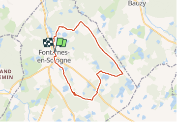
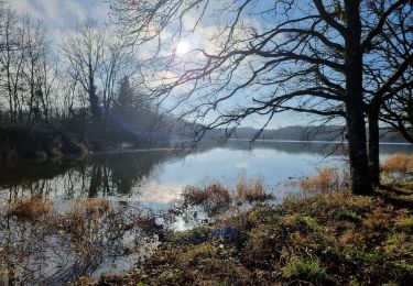
Ruta Senderismo de 14 km a descubrir en Centro, Loir y Cher, Fontaines-en-Sologne. Esta ruta ha sido propuesta por mimilolo.
Descripción
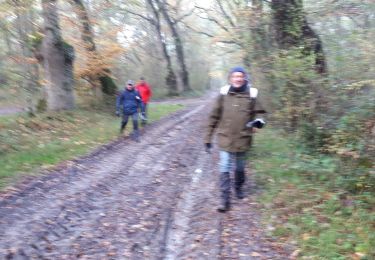
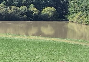
depart parking école belle rando à travers les étangs bien appréciée de tout le monde évite la route gardé leGR au début de la rando oblique à gauche
Localización
País:
France
Región :
Centro
Departamento/provincia :
Loir y Cher
Municipio :
Fontaines-en-Sologne
Localidad:
Unknown
Salida:(Dec)
Salida:(UTM)
390889 ; 5262937 (31T) N.
Comentarios
Excursiones cerca
![Excursión Senderismo Tour-en-Sologne - tours en sologne 2019 - Photo](https://media.geolcdn.com/t/375/260/10917737-5185-4205-9a99-f8125a6005f8.jpg&format=jpg&maxdim=2)
![Senderismo Senderismo](https://static1.geolcdn.com/sitytour/trail-icons/101.png)
tours en sologne 2019
Senderismo
Muy fácil
Tour-en-Sologne,
Centro,
Loir y Cher,
France
![](/images/other/stat-length.png)
14 km | 15,5 km-effort
3h 2min
![](https://static1.geolcdn.com/siteimages/upload/files/16400158638029165_repeat_loop_refresh_sync_direction_icon.png)
Sí
![Excursión Senderismo Tour-en-Sologne - balade autour de tour-en-sologne - Photo](https://media.geolcdn.com/t/375/260/ext.jpg?maxdim=2&url=https%3A%2F%2Fservices.sitytrail.com%2FGeolivesWS%2FDownloadMedia.ashx%3FTrailID%3D1061579%26Media%3Dfix__20181025115406.jpg)
![Senderismo Senderismo](https://static1.geolcdn.com/sitytour/trail-icons/101.png)
balade autour de tour-en-sologne
Senderismo
Fácil
Tour-en-Sologne,
Centro,
Loir y Cher,
France
![](/images/other/stat-length.png)
12,8 km | 14,1 km-effort
2h 21min
![](https://static1.geolcdn.com/siteimages/upload/files/16400158638029165_repeat_loop_refresh_sync_direction_icon.png)
No
![Excursión Senderismo Tour-en-Sologne - boucle tour de Sologne - Photo](https://media.geolcdn.com/t/375/260/ext.jpg?maxdim=2&url=https%3A%2F%2Fservices.sitytrail.com%2FGeolivesWS%2FDownloadMedia.ashx%3FTrailID%3D1061472%26Media%3Dfix__20181025115406.jpg)
![Senderismo Senderismo](https://static1.geolcdn.com/sitytour/trail-icons/101.png)
boucle tour de Sologne
Senderismo
Fácil
Tour-en-Sologne,
Centro,
Loir y Cher,
France
![](/images/other/stat-length.png)
11,7 km | 12,9 km-effort
2h 18min
![](https://static1.geolcdn.com/siteimages/upload/files/16400158638029165_repeat_loop_refresh_sync_direction_icon.png)
Sí
![Excursión Bicicleta Bracieux - Au pays de Raboliot - Bracieux - Photo](https://media.geolcdn.com/t/375/260/ext.jpg?maxdim=2&url=https%3A%2F%2Fservices.sitytrail.com%2FGeolivesWS%2FDownloadMedia.ashx%3FTrailID%3D106100%26Media%3D10327_6.jpg)
![Bicicleta Bicicleta](https://static1.geolcdn.com/sitytour/trail-icons/200.png)
Au pays de Raboliot - Bracieux
Bicicleta
Fácil
Bracieux,
Centro,
Loir y Cher,
France
![](/images/other/stat-length.png)
29 km | 33 km-effort
1h 30min
![](https://static1.geolcdn.com/siteimages/upload/files/16400158638029165_repeat_loop_refresh_sync_direction_icon.png)
Sí
![Excursión Senderismo Bracieux - bracieux gs 12km - Photo](https://media.geolcdn.com/t/375/260/181009ec-09de-4b00-9912-0d64e1c3a913.jpg&format=jpg&maxdim=2)
![Senderismo Senderismo](https://static1.geolcdn.com/sitytour/trail-icons/101.png)
bracieux gs 12km
Senderismo
Fácil
Bracieux,
Centro,
Loir y Cher,
France
![](/images/other/stat-length.png)
11,5 km | 12,7 km-effort
2h 39min
![](https://static1.geolcdn.com/siteimages/upload/files/16400158638029165_repeat_loop_refresh_sync_direction_icon.png)
Sí
![Excursión Senderismo Tour-en-Sologne - tour en sologne - Photo](https://media.geolcdn.com/t/375/260/5a006381-1efb-4a7d-b68e-72d11e51ea0c.jpg&format=jpg&maxdim=2)
![Senderismo Senderismo](https://static1.geolcdn.com/sitytour/trail-icons/101.png)
tour en sologne
Senderismo
Difícil
Tour-en-Sologne,
Centro,
Loir y Cher,
France
![](/images/other/stat-length.png)
12,6 km | 14 km-effort
2h 35min
![](https://static1.geolcdn.com/siteimages/upload/files/16400158638029165_repeat_loop_refresh_sync_direction_icon.png)
Sí
![Excursión Senderismo Bauzy - Chemin de la locature - Bauzy - Photo](https://media.geolcdn.com/t/375/260/ext.jpg?maxdim=2&url=https%3A%2F%2Fservices.sitytrail.com%2FGeolivesWS%2FDownloadMedia.ashx%3FTrailID%3D317874%26Media%3D17264_2.jpg)
![Senderismo Senderismo](https://static1.geolcdn.com/sitytour/trail-icons/101.png)
Chemin de la locature - Bauzy
Senderismo
Medio
Bauzy,
Centro,
Loir y Cher,
France
![](/images/other/stat-length.png)
8,2 km | 9,2 km-effort
2h 4min
![](https://static1.geolcdn.com/siteimages/upload/files/16400158638029165_repeat_loop_refresh_sync_direction_icon.png)
Sí
![Excursión Senderismo Bauzy - Passant par les Bois - Bauzy - Photo](https://media.geolcdn.com/t/375/260/ext.jpg?maxdim=2&url=https%3A%2F%2Fservices.sitytrail.com%2FGeolivesWS%2FDownloadMedia.ashx%3FTrailID%3D317873%26Media%3D17263_2.jpg)
![Senderismo Senderismo](https://static1.geolcdn.com/sitytour/trail-icons/101.png)
Passant par les Bois - Bauzy
Senderismo
Medio
Bauzy,
Centro,
Loir y Cher,
France
![](/images/other/stat-length.png)
9,6 km | 10,7 km-effort
2h 25min
![](https://static1.geolcdn.com/siteimages/upload/files/16400158638029165_repeat_loop_refresh_sync_direction_icon.png)
Sí
![Excursión Senderismo Bauzy - Entre forêt et manoir - Bauzy - Photo](https://media.geolcdn.com/t/375/260/ext.jpg?maxdim=2&url=https%3A%2F%2Fservices.sitytrail.com%2FGeolivesWS%2FDownloadMedia.ashx%3FTrailID%3D317872%26Media%3D17262_2.jpg)
![Senderismo Senderismo](https://static1.geolcdn.com/sitytour/trail-icons/101.png)
Entre forêt et manoir - Bauzy
Senderismo
Medio
Bauzy,
Centro,
Loir y Cher,
France
![](/images/other/stat-length.png)
12,4 km | 13,9 km-effort
3h 4min
![](https://static1.geolcdn.com/siteimages/upload/files/16400158638029165_repeat_loop_refresh_sync_direction_icon.png)
Sí