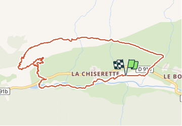
![](/images/other/stat-length.png)
Via ferrata Plan de Bouc
djrem971
Usuario
![Longitud](/images/other/stat-length.png)
![Altitud máxima](https://static1.geolcdn.com/siteimages/upload/files/1508320355ic_sort_altitude_max_24dp.png)
![Desnivel positivo](https://static1.geolcdn.com/siteimages/upload/files/1508320355ic_sort_den_pos_24dp.png)
![Km-Effort](/images/other/stat-length.png)
![Altitud mínima](https://static1.geolcdn.com/siteimages/upload/files/1508320355ic_sort_altitude_min_24dp.png)
![Desnivel negativo](https://static1.geolcdn.com/siteimages/upload/files/1508320355ic_sort_den_neg_24dp.png)
![Boucle](https://static1.geolcdn.com/siteimages/upload/files/16400158638029165_repeat_loop_refresh_sync_direction_icon.png)
![Vía ferrata](https://static1.geolcdn.com/sitytour/trail-icons/902.png)
2h57
Dificultad : Muy fácil
![Escanee este código QR para abrir la excursión en la aplicación SityTrail](https://capi.geolives.com/qq0zvz2zws4bq2lad0pu/sitytour/trails/2827677/qr.png?size=200)
Aplicación GPS de excursión GRATIS
A propósito
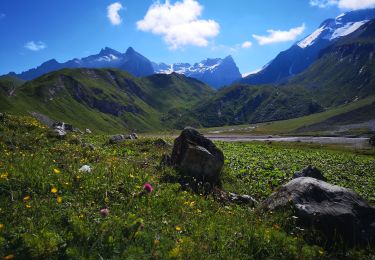
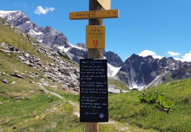
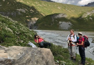
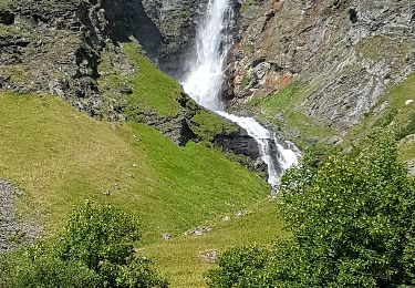
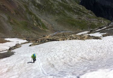
Ruta Vía ferrata de 6,4 km a descubrir en Auvergne-Rhône-Alpes, Saboya, Champagny-en-Vanoise. Esta ruta ha sido propuesta por djrem971.
Descripción
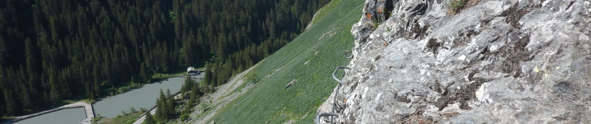
Cette via ferrata ne présente strictement aucune difficulté, seules les marches d'approche et de retour peuvent paraître assez longues.
Très belle vue, le passage de l'unique échelle du parcours est une bonne initiation à ce type d'accessoire dans les via.
Localización
Comentarios
Excursiones cerca
![Excursión Senderismo Champagny-en-Vanoise - col du plan Séry et du palet - Photo](https://media.geolcdn.com/t/375/260/69b57f21-ba87-483d-8fa5-10752fbbf208.jpg&format=jpg&maxdim=2)
![Senderismo Senderismo](https://static1.geolcdn.com/sitytour/trail-icons/101.png)
Senderismo
![](/images/other/stat-length.png)
![](https://static1.geolcdn.com/siteimages/upload/files/16400158638029165_repeat_loop_refresh_sync_direction_icon.png)
![Excursión Senderismo Planay - le refuge du Grand Bec (boucle) - Photo](https://media.geolcdn.com/t/375/260/922fab93-817c-41fb-abcc-50a27af96e54.jpg&format=jpg&maxdim=2)
![Senderismo Senderismo](https://static1.geolcdn.com/sitytour/trail-icons/101.png)
Senderismo
![](/images/other/stat-length.png)
![](https://static1.geolcdn.com/siteimages/upload/files/16400158638029165_repeat_loop_refresh_sync_direction_icon.png)
![Excursión Senderismo Champagny-en-Vanoise - Sentier des glaciers-Vanoise 18 07 2020 - Photo](https://media.geolcdn.com/t/375/260/6c753556-2927-4df0-8c6a-93e196eff404.jpg&format=jpg&maxdim=2)
![Senderismo Senderismo](https://static1.geolcdn.com/sitytour/trail-icons/101.png)
Senderismo
![](/images/other/stat-length.png)
![](https://static1.geolcdn.com/siteimages/upload/files/16400158638029165_repeat_loop_refresh_sync_direction_icon.png)
![Excursión Senderismo Planay - Le refuge du Grand Bec - Photo](https://media.geolcdn.com/t/375/260/62079f41-6456-403e-9adb-431c7cf6ef91.jpg&format=jpg&maxdim=2)
![Senderismo Senderismo](https://static1.geolcdn.com/sitytour/trail-icons/101.png)
Senderismo
![](/images/other/stat-length.png)
![](https://static1.geolcdn.com/siteimages/upload/files/16400158638029165_repeat_loop_refresh_sync_direction_icon.png)
![Excursión Senderismo Champagny-en-Vanoise - La Glières - Photo](https://media.geolcdn.com/t/375/260/19849bd1-ad2f-4bb3-b2cf-15a17bec9903.jpg&format=jpg&maxdim=2)
![Senderismo Senderismo](https://static1.geolcdn.com/sitytour/trail-icons/101.png)
Senderismo
![](/images/other/stat-length.png)
![](https://static1.geolcdn.com/siteimages/upload/files/16400158638029165_repeat_loop_refresh_sync_direction_icon.png)
![Excursión Senderismo Champagny-en-Vanoise - Le lac de la gliere - Photo](https://media.geolcdn.com/t/375/260/c8ad1819-128d-42fc-9005-e8b6e56b8154.jpg&format=jpg&maxdim=2)
![Senderismo Senderismo](https://static1.geolcdn.com/sitytour/trail-icons/101.png)
Senderismo
![](/images/other/stat-length.png)
![](https://static1.geolcdn.com/siteimages/upload/files/16400158638029165_repeat_loop_refresh_sync_direction_icon.png)
![Excursión Senderismo Champagny-en-Vanoise - CHAMPAGNY-EN-VANOISE (73) - Photo](https://media.geolcdn.com/t/375/260/ext.jpg?maxdim=2&url=https%3A%2F%2Fservices.sitytrail.com%2FGeolivesWS%2FDownloadMedia.ashx%3FTrailID%3D1007079%26Media%3Dfix__20180719171504.jpg)
![Senderismo Senderismo](https://static1.geolcdn.com/sitytour/trail-icons/101.png)
Senderismo
![](/images/other/stat-length.png)
![](https://static1.geolcdn.com/siteimages/upload/files/16400158638029165_repeat_loop_refresh_sync_direction_icon.png)
![Excursión Senderismo Champagny-en-Vanoise - Le col de Charde (MTH-P) - Photo](https://media.geolcdn.com/t/375/260/ext.jpg?maxdim=2&url=https%3A%2F%2Fservices.sitytrail.com%2FGeolivesWS%2FDownloadMedia.ashx%3FTrailID%3D331992%26Media%3D20140807131136.jpg)
![Senderismo Senderismo](https://static1.geolcdn.com/sitytour/trail-icons/101.png)
Senderismo
![](/images/other/stat-length.png)
![](https://static1.geolcdn.com/siteimages/upload/files/16400158638029165_repeat_loop_refresh_sync_direction_icon.png)
![Excursión Bici de montaña La Plagne-Tarentaise - Crête des Etroits, Bécoin, Verdons et la Gde Rochette - Photo](https://media.geolcdn.com/t/375/260/ext.jpg?maxdim=2&url=https%3A%2F%2Fservices.sitytrail.com%2FGeolivesWS%2FDownloadMedia.ashx%3FTrailID%3D101086%26Media%3D575_3.jpg)
![Bici de montaña Bici de montaña](https://static1.geolcdn.com/sitytour/trail-icons/202.png)
Bici de montaña
![](/images/other/stat-length.png)
![](https://static1.geolcdn.com/siteimages/upload/files/16400158638029165_repeat_loop_refresh_sync_direction_icon.png)