![](/images/other/stat-length.png)
![Excursión Senderismo Cancale - Cancale sentier du littoral 14.06.21 - Photo](https://media.geolcdn.com/t/1900/400/ext.pjpeg?maxdim=2&url=https%3A%2F%2Fstatic1.geolcdn.com%2Fsiteimages%2Fupload%2Ffiles%2F1553511878bg_sport_marche.png)
Cancale sentier du littoral 14.06.21
joelclaudel
Usuario
![Longitud](/images/other/stat-length.png)
Longitud
14 km
![Altitud máxima](https://static1.geolcdn.com/siteimages/upload/files/1508320355ic_sort_altitude_max_24dp.png)
Altitud máxima
51 m
![Desnivel positivo](https://static1.geolcdn.com/siteimages/upload/files/1508320355ic_sort_den_pos_24dp.png)
Desnivel positivo
209 m
![Km-Effort](/images/other/stat-length.png)
Km-Effort
16,8 km
![Altitud mínima](https://static1.geolcdn.com/siteimages/upload/files/1508320355ic_sort_altitude_min_24dp.png)
Altitud mínima
2 m
![Desnivel negativo](https://static1.geolcdn.com/siteimages/upload/files/1508320355ic_sort_den_neg_24dp.png)
Desnivel negativo
207 m
![Boucle](https://static1.geolcdn.com/siteimages/upload/files/16400158638029165_repeat_loop_refresh_sync_direction_icon.png)
Boucle
Sí
Fecha de creación :
2021-06-14 09:10:54.107
Última modificación :
2021-06-14 15:34:19.325
![Senderismo](https://static1.geolcdn.com/sitytour/trail-icons/101.png)
3h49
Dificultad : Medio
![Escanee este código QR para abrir la excursión en la aplicación SityTrail](https://capi.geolives.com/qq0zvz2zws4bq2lad0pu/sitytour/trails/2826780/qr.png?size=200)
Aplicación GPS de excursión GRATIS
A propósito
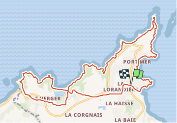
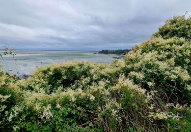
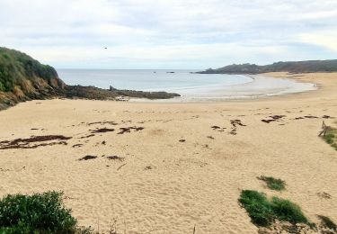
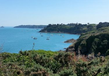
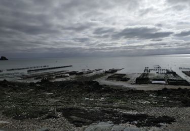
Ruta Senderismo de 14 km a descubrir en Bretaña, Ille-et-Vilaine, Cancale. Esta ruta ha sido propuesta por joelclaudel.
Descripción
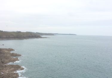
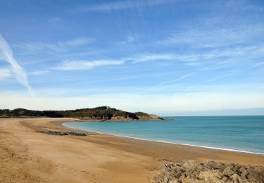
Sentier du littoral, Pointes de Grouin et de Rochefroide, plage du Saussaye, Pointe de l Moulière, plage du Verger, Pointe du Nid.
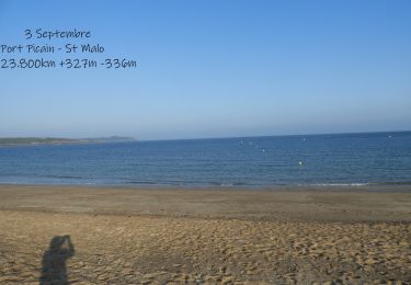
Départ Port Pican (parking payant.
Localización
País:
France
Región :
Bretaña
Departamento/provincia :
Ille-et-Vilaine
Municipio :
Cancale
Localidad:
Unknown
Salida:(Dec)
Salida:(UTM)
584452 ; 5394320 (30U) N.
Comentarios
Excursiones cerca
![Excursión Senderismo Cancale - cancale-pointe du grouin - Photo](https://media.geolcdn.com/t/375/260/ext.jpg?maxdim=2&url=https%3A%2F%2Fservices.sitytrail.com%2FGeolivesWS%2FDownloadMedia.ashx%3FTrailID%3D562635%26Media%3D20160502130406.jpg)
![Senderismo Senderismo](https://static1.geolcdn.com/sitytour/trail-icons/101.png)
cancale-pointe du grouin
Senderismo
Fácil
(1)
Cancale,
Bretaña,
Ille-et-Vilaine,
France
![](/images/other/stat-length.png)
7,4 km | 9,1 km-effort
2h 12min
![](https://static1.geolcdn.com/siteimages/upload/files/16400158638029165_repeat_loop_refresh_sync_direction_icon.png)
Sí
![Excursión Senderismo Cancale - Balade vers la Pointe du Grouin - Cancale - Photo](https://media.geolcdn.com/t/375/260/ext.jpg?maxdim=2&url=https%3A%2F%2Fservices.sitytrail.com%2FGeolivesWS%2FDownloadMedia.ashx%3FTrailID%3D317635%26Media%3D16903_4.jpg)
![Senderismo Senderismo](https://static1.geolcdn.com/sitytour/trail-icons/101.png)
Balade vers la Pointe du Grouin - Cancale
Senderismo
Medio
(4)
Cancale,
Bretaña,
Ille-et-Vilaine,
France
![](/images/other/stat-length.png)
13,2 km | 15,9 km-effort
3h 30min
![](https://static1.geolcdn.com/siteimages/upload/files/16400158638029165_repeat_loop_refresh_sync_direction_icon.png)
Sí
![Senderismo Senderismo](https://static1.geolcdn.com/sitytour/trail-icons/101.png)
SityTrail - GR 34 Port Picain -- Saint Malo
Senderismo
Muy difícil
Cancale,
Bretaña,
Ille-et-Vilaine,
France
![](/images/other/stat-length.png)
24 km | 28 km-effort
6h 24min
![](https://static1.geolcdn.com/siteimages/upload/files/16400158638029165_repeat_loop_refresh_sync_direction_icon.png)
No
![Excursión A pie Cancale - Balade rapide à Cancale (hors groupe) - Photo](https://media.geolcdn.com/t/375/260/8cca7f8b-f64f-48e7-9459-b60c481745c3.jpg&format=jpg&maxdim=2)
![A pie A pie](https://static1.geolcdn.com/sitytour/trail-icons/100.png)
Balade rapide à Cancale (hors groupe)
A pie
Fácil
Cancale,
Bretaña,
Ille-et-Vilaine,
France
![](/images/other/stat-length.png)
6 km | 7,9 km-effort
1h 47min
![](https://static1.geolcdn.com/siteimages/upload/files/16400158638029165_repeat_loop_refresh_sync_direction_icon.png)
Sí
![Excursión Senderismo Cancale - Boucle Anse du Guesclin - Photo](https://media.geolcdn.com/t/375/260/1d52cbbc-9ca2-4f7c-8936-3e1e451657b1.jpg&format=jpg&maxdim=2)
![Senderismo Senderismo](https://static1.geolcdn.com/sitytour/trail-icons/101.png)
Boucle Anse du Guesclin
Senderismo
Fácil
Cancale,
Bretaña,
Ille-et-Vilaine,
France
![](/images/other/stat-length.png)
6,1 km | 7,2 km-effort
2h 0min
![](https://static1.geolcdn.com/siteimages/upload/files/16400158638029165_repeat_loop_refresh_sync_direction_icon.png)
Sí
![Excursión Senderismo Cancale - Cancale Port Mer - 15.3km 290m 5h05 - 2017 06 19 - Photo](https://media.geolcdn.com/t/375/260/a3e4f02b-7f79-4247-9c5f-7345570d1680.jpg&format=jpg&maxdim=2)
![Senderismo Senderismo](https://static1.geolcdn.com/sitytour/trail-icons/101.png)
Cancale Port Mer - 15.3km 290m 5h05 - 2017 06 19
Senderismo
Fácil
Cancale,
Bretaña,
Ille-et-Vilaine,
France
![](/images/other/stat-length.png)
15,3 km | 18,5 km-effort
5h 0min
![](https://static1.geolcdn.com/siteimages/upload/files/16400158638029165_repeat_loop_refresh_sync_direction_icon.png)
Sí
![Excursión Marcha nórdica Cancale - TOUR DE BZH ETAPE 1 J N°2 - Photo](https://media.geolcdn.com/t/375/260/ext.jpg?maxdim=2&url=https%3A%2F%2Fstatic1.geolcdn.com%2Fsiteimages%2Fupload%2Ffiles%2F1545311037marcheuse_200dpi.jpg)
![Marcha nórdica Marcha nórdica](https://static1.geolcdn.com/sitytour/trail-icons/102.png)
TOUR DE BZH ETAPE 1 J N°2
Marcha nórdica
Muy fácil
(1)
Cancale,
Bretaña,
Ille-et-Vilaine,
France
![](/images/other/stat-length.png)
15,8 km | 18,7 km-effort
3h 19min
![](https://static1.geolcdn.com/siteimages/upload/files/16400158638029165_repeat_loop_refresh_sync_direction_icon.png)
No
![Excursión Otra actividad Cancale - Draft _ Pointe du Grouin court - Photo](https://media.geolcdn.com/t/375/260/ext.jpg?maxdim=2&url=https%3A%2F%2Fstatic1.geolcdn.com%2Fsiteimages%2Fupload%2Ffiles%2F1545311037marcheuse_200dpi.jpg)
![Otra actividad Otra actividad](https://static1.geolcdn.com/sitytour/trail-icons/900.png)
Draft _ Pointe du Grouin court
Otra actividad
Muy fácil
(1)
Cancale,
Bretaña,
Ille-et-Vilaine,
France
![](/images/other/stat-length.png)
9 km | 11,1 km-effort
2h 0min
![](https://static1.geolcdn.com/siteimages/upload/files/16400158638029165_repeat_loop_refresh_sync_direction_icon.png)
Sí
![Excursión Senderismo Cancale - 2024-03-19 boucle Cancale - Photo](https://media.geolcdn.com/t/375/260/67015cb6-a876-416e-8bce-1c916afa0c03.jpg&format=jpg&maxdim=2)
![Senderismo Senderismo](https://static1.geolcdn.com/sitytour/trail-icons/101.png)
2024-03-19 boucle Cancale
Senderismo
Medio
Cancale,
Bretaña,
Ille-et-Vilaine,
France
![](/images/other/stat-length.png)
9,7 km | 12 km-effort
2h 25min
![](https://static1.geolcdn.com/siteimages/upload/files/16400158638029165_repeat_loop_refresh_sync_direction_icon.png)
Sí