![](/images/other/stat-length.png)
![Excursión Bici eléctrica Meysse - Au dessus de Meysse-Cruas - Photo](https://media.geolcdn.com/t/1900/400/ext.pjpeg?maxdim=2&url=https%3A%2F%2Fstatic1.geolcdn.com%2Fsiteimages%2Fupload%2Ffiles%2F1524743154velo.jpg)
Au dessus de Meysse-Cruas
Duroland35
Usuario
![Longitud](/images/other/stat-length.png)
Longitud
34 km
![Altitud máxima](https://static1.geolcdn.com/siteimages/upload/files/1508320355ic_sort_altitude_max_24dp.png)
Altitud máxima
507 m
![Desnivel positivo](https://static1.geolcdn.com/siteimages/upload/files/1508320355ic_sort_den_pos_24dp.png)
Desnivel positivo
958 m
![Km-Effort](/images/other/stat-length.png)
Km-Effort
47 km
![Altitud mínima](https://static1.geolcdn.com/siteimages/upload/files/1508320355ic_sort_altitude_min_24dp.png)
Altitud mínima
69 m
![Desnivel negativo](https://static1.geolcdn.com/siteimages/upload/files/1508320355ic_sort_den_neg_24dp.png)
Desnivel negativo
959 m
![Boucle](https://static1.geolcdn.com/siteimages/upload/files/16400158638029165_repeat_loop_refresh_sync_direction_icon.png)
Boucle
Sí
Fecha de creación :
2021-06-13 07:20:43.921
Última modificación :
2021-06-13 10:37:11.695
![Bici eléctrica](https://static1.geolcdn.com/sitytour/trail-icons/205.png)
2h00
Dificultad : Medio
![Escanee este código QR para abrir la excursión en la aplicación SityTrail](https://capi.geolives.com/qq0zvz2zws4bq2lad0pu/sitytour/trails/2825175/qr.png?size=200)
Aplicación GPS de excursión GRATIS
A propósito
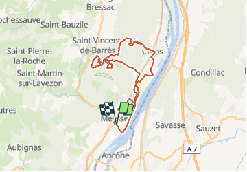
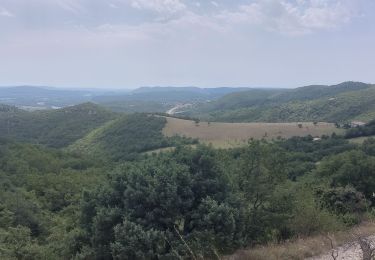
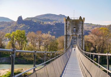
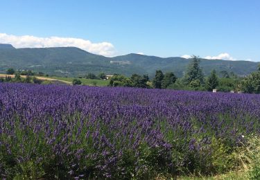
Ruta Bici eléctrica de 34 km a descubrir en Auvergne-Rhône-Alpes, Ardecha, Meysse. Esta ruta ha sido propuesta por Duroland35.
Descripción
Un tour sympa, bien abrité du vent et du soleil pour une bonne partie...mais un dénivelé significatif toud'même 😉
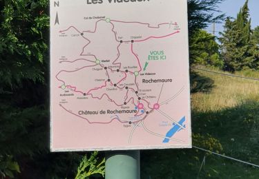
Localización
País:
France
Región :
Auvergne-Rhône-Alpes
Departamento/provincia :
Ardecha
Municipio :
Meysse
Localidad:
Unknown
Salida:(Dec)
Salida:(UTM)
637029 ; 4940548 (31T) N.
Comentarios
Excursiones cerca
![Excursión Senderismo Meysse - Messe - pic chenavari -chateau de rochemaure - Photo](https://media.geolcdn.com/t/375/260/446a9ac6-cc6d-4429-b7ae-6be08bd52b14.jpg&format=jpg&maxdim=2)
![Senderismo Senderismo](https://static1.geolcdn.com/sitytour/trail-icons/101.png)
Messe - pic chenavari -chateau de rochemaure
Senderismo
Medio
(2)
Meysse,
Auvergne-Rhône-Alpes,
Ardecha,
France
![](/images/other/stat-length.png)
15 km | 23 km-effort
3h 51min
![](https://static1.geolcdn.com/siteimages/upload/files/16400158638029165_repeat_loop_refresh_sync_direction_icon.png)
Sí
![Excursión Senderismo Rochemaure - Randonnée entre Rochemaure et Aubignas - Photo](https://media.geolcdn.com/t/375/260/ext.jpg?maxdim=2&url=https%3A%2F%2Fservices.sitytrail.com%2FGeolivesWS%2FDownloadMedia.ashx%3FTrailID%3D104553%26Media%3D7931_3.jpg)
![Senderismo Senderismo](https://static1.geolcdn.com/sitytour/trail-icons/101.png)
Randonnée entre Rochemaure et Aubignas
Senderismo
Difícil
(2)
Rochemaure,
Auvergne-Rhône-Alpes,
Ardecha,
France
![](/images/other/stat-length.png)
16,8 km | 26 km-effort
5h 30min
![](https://static1.geolcdn.com/siteimages/upload/files/16400158638029165_repeat_loop_refresh_sync_direction_icon.png)
Sí
![Excursión Senderismo Rochemaure - Rochemaure - Photo](https://media.geolcdn.com/t/375/260/ext.jpg?maxdim=2&url=https%3A%2F%2Fservices.sitytrail.com%2FGeolivesWS%2FDownloadMedia.ashx%3FTrailID%3D109893%26Media%3D4900_1.jpg)
![Senderismo Senderismo](https://static1.geolcdn.com/sitytour/trail-icons/101.png)
Rochemaure
Senderismo
Medio
(3)
Rochemaure,
Auvergne-Rhône-Alpes,
Ardecha,
France
![](/images/other/stat-length.png)
8,8 km | 13,6 km-effort
3h 0min
![](https://static1.geolcdn.com/siteimages/upload/files/16400158638029165_repeat_loop_refresh_sync_direction_icon.png)
Sí
![Excursión Senderismo Rochemaure - Le Chenavary 11km. - Photo](https://media.geolcdn.com/t/375/260/dfb34e99-cb97-4de8-a99a-52eb6b293bd1.jpg&format=jpg&maxdim=2)
![Senderismo Senderismo](https://static1.geolcdn.com/sitytour/trail-icons/101.png)
Le Chenavary 11km.
Senderismo
Difícil
Rochemaure,
Auvergne-Rhône-Alpes,
Ardecha,
France
![](/images/other/stat-length.png)
11 km | 17,3 km-effort
3h 56min
![](https://static1.geolcdn.com/siteimages/upload/files/16400158638029165_repeat_loop_refresh_sync_direction_icon.png)
Sí
![Excursión Senderismo Ancône - 2022-09-27_13h14m41_14402810-1 - Photo](https://media.geolcdn.com/t/375/260/cb008533-e372-48c7-9f09-091e6cae99d0.jpg&format=jpg&maxdim=2)
![Senderismo Senderismo](https://static1.geolcdn.com/sitytour/trail-icons/101.png)
2022-09-27_13h14m41_14402810-1
Senderismo
Medio
Ancône,
Auvergne-Rhône-Alpes,
Drôme,
France
![](/images/other/stat-length.png)
16,1 km | 17,6 km-effort
4h 0min
![](https://static1.geolcdn.com/siteimages/upload/files/16400158638029165_repeat_loop_refresh_sync_direction_icon.png)
Sí
![Excursión Senderismo Savasse - 2022-09-26_14h15m29_13096793 - Photo](https://media.geolcdn.com/t/375/260/2b473090-d36a-43fd-b8eb-9c5f8eb23398.jpg&format=jpg&maxdim=2)
![Senderismo Senderismo](https://static1.geolcdn.com/sitytour/trail-icons/101.png)
2022-09-26_14h15m29_13096793
Senderismo
Medio
Savasse,
Auvergne-Rhône-Alpes,
Drôme,
France
![](/images/other/stat-length.png)
6,9 km | 10,4 km-effort
2h 21min
![](https://static1.geolcdn.com/siteimages/upload/files/16400158638029165_repeat_loop_refresh_sync_direction_icon.png)
Sí
![Excursión Senderismo Rochemaure - tour du chenavari - Photo](https://media.geolcdn.com/t/375/260/ext.jpg?maxdim=2&url=https%3A%2F%2Fstatic1.geolcdn.com%2Fsiteimages%2Fupload%2Ffiles%2F1553511878bg_sport_marche.png)
![Senderismo Senderismo](https://static1.geolcdn.com/sitytour/trail-icons/101.png)
tour du chenavari
Senderismo
Medio
(1)
Rochemaure,
Auvergne-Rhône-Alpes,
Ardecha,
France
![](/images/other/stat-length.png)
6,3 km | 9,5 km-effort
2h 0min
![](https://static1.geolcdn.com/siteimages/upload/files/16400158638029165_repeat_loop_refresh_sync_direction_icon.png)
Sí
![Excursión Senderismo Rochemaure - Château de Rochemaure, Pic de Chenavari. - Photo](https://media.geolcdn.com/t/375/260/6c8a3c6f-4dcf-44b9-a997-a4440eb044c8.jpg&format=jpg&maxdim=2)
![Senderismo Senderismo](https://static1.geolcdn.com/sitytour/trail-icons/101.png)
Château de Rochemaure, Pic de Chenavari.
Senderismo
Difícil
Rochemaure,
Auvergne-Rhône-Alpes,
Ardecha,
France
![](/images/other/stat-length.png)
16,6 km | 26 km-effort
5h 58min
![](https://static1.geolcdn.com/siteimages/upload/files/16400158638029165_repeat_loop_refresh_sync_direction_icon.png)
Sí
![Senderismo Senderismo](https://static1.geolcdn.com/sitytour/trail-icons/101.png)
2024-09-29_18h58m11_t302612787_10 km ressource 2024
Senderismo
Difícil
Savasse,
Auvergne-Rhône-Alpes,
Drôme,
France
![](/images/other/stat-length.png)
9,3 km | 13,1 km-effort
2h 58min
![](https://static1.geolcdn.com/siteimages/upload/files/16400158638029165_repeat_loop_refresh_sync_direction_icon.png)
Sí