![](/images/other/stat-length.png)
![Excursión Senderismo Le Castellard-Mélan - Geruen au départ du col de Fontbelle - Photo](https://media.geolcdn.com/t/1900/400/b6b72807-9cda-421f-aadf-c3f6f0a4ac53.jpg&format=pjpeg&maxdim=2)
Geruen au départ du col de Fontbelle
jalien04
Usuario
![Longitud](/images/other/stat-length.png)
![Altitud máxima](https://static1.geolcdn.com/siteimages/upload/files/1508320355ic_sort_altitude_max_24dp.png)
![Desnivel positivo](https://static1.geolcdn.com/siteimages/upload/files/1508320355ic_sort_den_pos_24dp.png)
![Km-Effort](/images/other/stat-length.png)
![Altitud mínima](https://static1.geolcdn.com/siteimages/upload/files/1508320355ic_sort_altitude_min_24dp.png)
![Desnivel negativo](https://static1.geolcdn.com/siteimages/upload/files/1508320355ic_sort_den_neg_24dp.png)
![Boucle](https://static1.geolcdn.com/siteimages/upload/files/16400158638029165_repeat_loop_refresh_sync_direction_icon.png)
![Senderismo](https://static1.geolcdn.com/sitytour/trail-icons/101.png)
6h51
Dificultad : Fácil
![Escanee este código QR para abrir la excursión en la aplicación SityTrail](https://capi.geolives.com/qq0zvz2zws4bq2lad0pu/sitytour/trails/2824048/qr.png?size=200)
Aplicación GPS de excursión GRATIS
A propósito
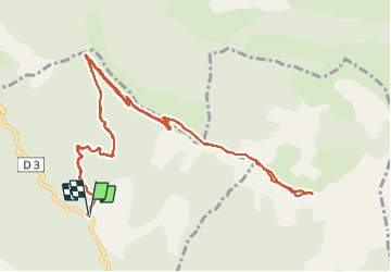
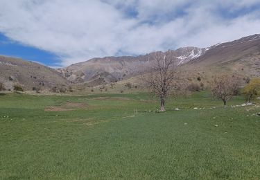
Ruta Senderismo de 15,1 km a descubrir en Provenza-Alpes-Costa Azul, Alpes de Alta Provenza, Le Castellard-Mélan. Esta ruta ha sido propuesta por jalien04.
Descripción
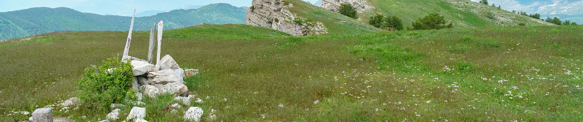
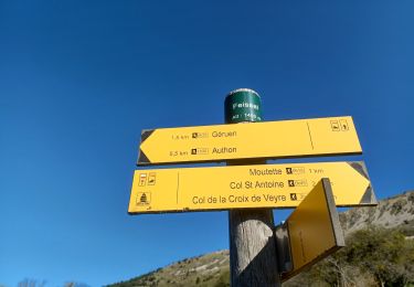
Piste et montée douce et essentiellement ombragée jusqu'au petit col de l'ubac de Géruen. Suivre le sentier amont le plus proche du bord de la falaise sans pour autant craindre le vertige, jusqu'au sommet 1 860m. Beaucoup de fleurs de fin mai à mi-juin, des eidelweiss et lavandes en juillet. Un espace sommital particulièrement apprécié!
Localización
Comentarios
Excursiones cerca
![Excursión Senderismo Hautes-Duyes - geruen sentier des chamois - Photo](https://media.geolcdn.com/t/375/260/76e6f18d-9f19-4351-821e-ec84b6202ed5.jpg&format=jpg&maxdim=2)
![Senderismo Senderismo](https://static1.geolcdn.com/sitytour/trail-icons/101.png)
Senderismo
![](/images/other/stat-length.png)
![](https://static1.geolcdn.com/siteimages/upload/files/16400158638029165_repeat_loop_refresh_sync_direction_icon.png)
![Excursión Senderismo Le Castellard-Mélan - MELAN . Col de Mounis , sommet du Corbeau o l s - Photo](https://media.geolcdn.com/t/375/260/2b656901-381a-4dfe-a9e9-2df9166addba.jpg&format=jpg&maxdim=2)
![Senderismo Senderismo](https://static1.geolcdn.com/sitytour/trail-icons/101.png)
Senderismo
![](/images/other/stat-length.png)
![](https://static1.geolcdn.com/siteimages/upload/files/16400158638029165_repeat_loop_refresh_sync_direction_icon.png)
![Excursión Senderismo Authon - 20180912_Monges_Authon_Boucle_Sommet Coste belle - Photo](https://media.geolcdn.com/t/375/260/ext.jpg?maxdim=2&url=https%3A%2F%2Fservices.sitytrail.com%2FGeolivesWS%2FDownloadMedia.ashx%3FTrailID%3D1038487%26Media%3D0586817d-9cc9-405c-aa4b-393c8043fb42.jpg)
![Senderismo Senderismo](https://static1.geolcdn.com/sitytour/trail-icons/101.png)
Senderismo
![](/images/other/stat-length.png)
![](https://static1.geolcdn.com/siteimages/upload/files/16400158638029165_repeat_loop_refresh_sync_direction_icon.png)
![Excursión Senderismo Authon - AUTHON Faissal La Croix de Vey ré Sommet de Chine o - Photo](https://media.geolcdn.com/t/375/260/ext.jpg?maxdim=2&url=https%3A%2F%2Fstatic1.geolcdn.com%2Fsiteimages%2Fupload%2Ffiles%2F1553511878bg_sport_marche.png)
![Senderismo Senderismo](https://static1.geolcdn.com/sitytour/trail-icons/101.png)
Senderismo
![](/images/other/stat-length.png)
![](https://static1.geolcdn.com/siteimages/upload/files/16400158638029165_repeat_loop_refresh_sync_direction_icon.png)
![Excursión Senderismo Le Castellard-Mélan - Autour de Fontbelle 18/12/2024 - Photo](https://media.geolcdn.com/t/375/260/69b9121f-8e6a-46ef-affd-f6d0486b57b2.jpg&format=jpg&maxdim=2)
![Senderismo Senderismo](https://static1.geolcdn.com/sitytour/trail-icons/101.png)
Senderismo
![](/images/other/stat-length.png)
![](https://static1.geolcdn.com/siteimages/upload/files/16400158638029165_repeat_loop_refresh_sync_direction_icon.png)
![Excursión Senderismo Authon - AUTHON. GROTTE. COL DE L AIGUILLE O L - Photo](https://media.geolcdn.com/t/375/260/ddbf7ae4-52a3-4044-bf29-d39533b6071a.jpg&format=jpg&maxdim=2)
![Senderismo Senderismo](https://static1.geolcdn.com/sitytour/trail-icons/101.png)
Senderismo
![](/images/other/stat-length.png)
![](https://static1.geolcdn.com/siteimages/upload/files/16400158638029165_repeat_loop_refresh_sync_direction_icon.png)
![Excursión Senderismo Authon - AUTHON . FAISSAL .LES MONGES . LA CROIX DE VEYRE O L M - Photo](https://media.geolcdn.com/t/375/260/37444576-1d8a-41eb-baa4-0ccab1de4208.jpg&format=jpg&maxdim=2)
![Senderismo Senderismo](https://static1.geolcdn.com/sitytour/trail-icons/101.png)
Senderismo
![](/images/other/stat-length.png)
![](https://static1.geolcdn.com/siteimages/upload/files/16400158638029165_repeat_loop_refresh_sync_direction_icon.png)
![Excursión Senderismo Authon - AUTHON . COL DE LA SAPIE .CRETE DU CLOT DES MARTHES . CABAN DE CHINE N - Photo](https://media.geolcdn.com/t/375/260/1a094800-6822-4f02-a313-8060ac76a0c2.jpg&format=jpg&maxdim=2)
![Senderismo Senderismo](https://static1.geolcdn.com/sitytour/trail-icons/101.png)
Senderismo
![](/images/other/stat-length.png)
![](https://static1.geolcdn.com/siteimages/upload/files/16400158638029165_repeat_loop_refresh_sync_direction_icon.png)
![Excursión Senderismo Hautes-Duyes - Crête de Géruën descente sud Est - Photo](https://media.geolcdn.com/t/375/260/896db46e-982b-48f6-bf8f-c5ab98c282d0.jpg&format=jpg&maxdim=2)
![Senderismo Senderismo](https://static1.geolcdn.com/sitytour/trail-icons/101.png)
Senderismo
![](/images/other/stat-length.png)
![](https://static1.geolcdn.com/siteimages/upload/files/16400158638029165_repeat_loop_refresh_sync_direction_icon.png)