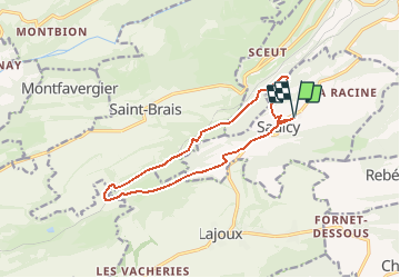
![](/images/other/stat-length.png)
![Excursión Senderismo Saulcy - Jura sauvage - Saulcy et les gorges du Tabeillon - Photo](https://media.geolcdn.com/t/1900/400/ext.pjpeg?maxdim=2&url=https%3A%2F%2Fstatic1.geolcdn.com%2Fsiteimages%2Fupload%2Ffiles%2F1553511878bg_sport_marche.png)
Jura sauvage - Saulcy et les gorges du Tabeillon
duamerg
Usuario
![Longitud](/images/other/stat-length.png)
![Altitud máxima](https://static1.geolcdn.com/siteimages/upload/files/1508320355ic_sort_altitude_max_24dp.png)
![Desnivel positivo](https://static1.geolcdn.com/siteimages/upload/files/1508320355ic_sort_den_pos_24dp.png)
![Km-Effort](/images/other/stat-length.png)
![Altitud mínima](https://static1.geolcdn.com/siteimages/upload/files/1508320355ic_sort_altitude_min_24dp.png)
![Desnivel negativo](https://static1.geolcdn.com/siteimages/upload/files/1508320355ic_sort_den_neg_24dp.png)
![Boucle](https://static1.geolcdn.com/siteimages/upload/files/16400158638029165_repeat_loop_refresh_sync_direction_icon.png)
![Senderismo](https://static1.geolcdn.com/sitytour/trail-icons/101.png)
4h18
Dificultad : Medio
![Escanee este código QR para abrir la excursión en la aplicación SityTrail](https://capi.geolives.com/qq0zvz2zws4bq2lad0pu/sitytour/trails/28178/qr.png?size=200)
Aplicación GPS de excursión GRATIS
A propósito
Ruta Senderismo de 12,9 km a descubrir en Jura, District de Delémont, Saulcy. Esta ruta ha sido propuesta por duamerg.
Descripción
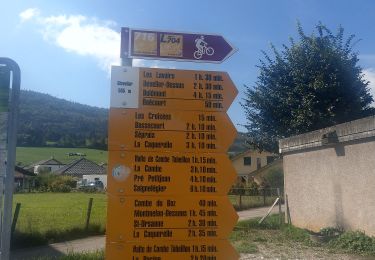
De Saulcy rejoindre 'sur les roches' en suivant les panneaux
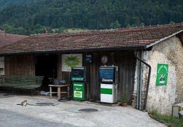
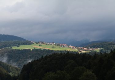
Descendre dans la combe. Restaurant de la gare.
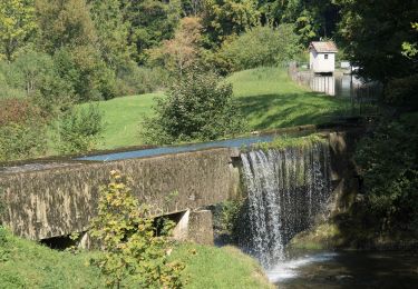
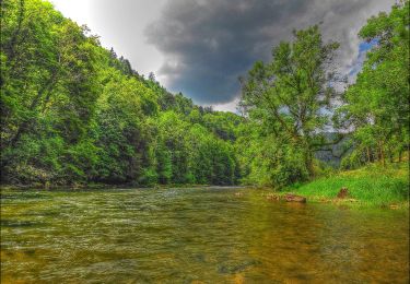
Suivre les panneaux 'combe Tabeillon' pour trouver un joli étang, des gorges et une barre rocheuse.
Forte montée pour retrouver le plateau de Saulcy.
Belle ballade intéressante et variée dans un vallon un peu inconnu.
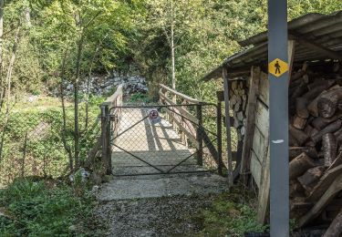
Voir photos.
Localización
Comentarios
Excursiones cerca
![Excursión A pie Saulcy - Saulcy - Undervelier - Photo](https://media.geolcdn.com/t/375/260/ee051455-45e4-451a-9c39-ecddc506b7b5.jpeg&format=jpg&maxdim=2)
![A pie A pie](https://static1.geolcdn.com/sitytour/trail-icons/100.png)
A pie
![](/images/other/stat-length.png)
![](https://static1.geolcdn.com/siteimages/upload/files/16400158638029165_repeat_loop_refresh_sync_direction_icon.png)
![Excursión A pie Saulcy - Saulcy - fixme - Photo](https://media.geolcdn.com/t/375/260/ac30ddf9-fb3f-420a-83a4-d7bfbdc6c2ce.jpeg&format=jpg&maxdim=2)
![A pie A pie](https://static1.geolcdn.com/sitytour/trail-icons/100.png)
A pie
![](/images/other/stat-length.png)
![](https://static1.geolcdn.com/siteimages/upload/files/16400158638029165_repeat_loop_refresh_sync_direction_icon.png)
![Excursión A pie Haute-Sorne - Berlincourt - fixme - Photo](https://media.geolcdn.com/t/375/260/72357a19-7dbe-43be-a37e-91c3499414df.jpeg&format=jpg&maxdim=2)
![A pie A pie](https://static1.geolcdn.com/sitytour/trail-icons/100.png)
A pie
![](/images/other/stat-length.png)
![](https://static1.geolcdn.com/siteimages/upload/files/16400158638029165_repeat_loop_refresh_sync_direction_icon.png)
![Excursión A pie Haute-Sorne - Berlincourt - La Racine - Photo](https://media.geolcdn.com/t/375/260/72357a19-7dbe-43be-a37e-91c3499414df.jpeg&format=jpg&maxdim=2)
![A pie A pie](https://static1.geolcdn.com/sitytour/trail-icons/100.png)
A pie
![](/images/other/stat-length.png)
![](https://static1.geolcdn.com/siteimages/upload/files/16400158638029165_repeat_loop_refresh_sync_direction_icon.png)
![Excursión A pie Haute-Sorne - Undervelier - Berlincourt - Photo](https://media.geolcdn.com/t/375/260/ac30ddf9-fb3f-420a-83a4-d7bfbdc6c2ce.jpeg&format=jpg&maxdim=2)
![A pie A pie](https://static1.geolcdn.com/sitytour/trail-icons/100.png)
A pie
![](/images/other/stat-length.png)
![](https://static1.geolcdn.com/siteimages/upload/files/16400158638029165_repeat_loop_refresh_sync_direction_icon.png)
![Excursión A pie Clos du Doubs - Passerelle de La Charbonniere - Soubey - Photo](https://media.geolcdn.com/t/375/260/827ab20e-fac6-4ddc-a128-657f5a8fe4c8.jpeg&format=jpg&maxdim=2)
![A pie A pie](https://static1.geolcdn.com/sitytour/trail-icons/100.png)
A pie
![](/images/other/stat-length.png)
![](https://static1.geolcdn.com/siteimages/upload/files/16400158638029165_repeat_loop_refresh_sync_direction_icon.png)
![Excursión A pie Haute-Sorne - Glovelier-St.Ursanne - Photo](https://media.geolcdn.com/t/375/260/584913b5-9279-4d14-8e86-e875dfda0129.jpeg&format=jpg&maxdim=2)
![A pie A pie](https://static1.geolcdn.com/sitytour/trail-icons/100.png)
A pie
![](/images/other/stat-length.png)
![](https://static1.geolcdn.com/siteimages/upload/files/16400158638029165_repeat_loop_refresh_sync_direction_icon.png)
![Excursión A pie Saint-Brais - Le Poye - fixme - Photo](https://media.geolcdn.com/t/375/260/091e7155-675e-45d4-8da6-1d843ef54918.jpeg&format=jpg&maxdim=2)
![A pie A pie](https://static1.geolcdn.com/sitytour/trail-icons/100.png)
A pie
![](/images/other/stat-length.png)
![](https://static1.geolcdn.com/siteimages/upload/files/16400158638029165_repeat_loop_refresh_sync_direction_icon.png)
![Excursión A pie Saint-Brais - Tariche - Pont de Ravines - Photo](https://media.geolcdn.com/t/375/260/976f4996-25f5-4d97-aa6d-b26d356687f2.jpeg&format=jpg&maxdim=2)
![A pie A pie](https://static1.geolcdn.com/sitytour/trail-icons/100.png)
A pie
![](/images/other/stat-length.png)
![](https://static1.geolcdn.com/siteimages/upload/files/16400158638029165_repeat_loop_refresh_sync_direction_icon.png)