![](/images/other/stat-length.png)
![Excursión Senderismo Colombiers - Colombier Canal bord de l'étang de Montady - Photo](https://media.geolcdn.com/t/1900/400/310d9c80-b9de-41ca-85c7-650068195f2b.jpg&format=pjpeg&maxdim=2)
Colombier Canal bord de l'étang de Montady
jll7513
Usuario
![Longitud](/images/other/stat-length.png)
![Altitud máxima](https://static1.geolcdn.com/siteimages/upload/files/1508320355ic_sort_altitude_max_24dp.png)
![Desnivel positivo](https://static1.geolcdn.com/siteimages/upload/files/1508320355ic_sort_den_pos_24dp.png)
![Km-Effort](/images/other/stat-length.png)
![Altitud mínima](https://static1.geolcdn.com/siteimages/upload/files/1508320355ic_sort_altitude_min_24dp.png)
![Desnivel negativo](https://static1.geolcdn.com/siteimages/upload/files/1508320355ic_sort_den_neg_24dp.png)
![Boucle](https://static1.geolcdn.com/siteimages/upload/files/16400158638029165_repeat_loop_refresh_sync_direction_icon.png)
![Senderismo](https://static1.geolcdn.com/sitytour/trail-icons/101.png)
2h16
Dificultad : Muy fácil
![Marcha nórdica](https://static1.geolcdn.com/sitytour/trail-icons/102.png)
1h42
Dificultad : Muy fácil
![Escanee este código QR para abrir la excursión en la aplicación SityTrail](https://capi.geolives.com/qq0zvz2zws4bq2lad0pu/sitytour/trails/2812077/qr.png?size=200)
Aplicación GPS de excursión GRATIS
A propósito
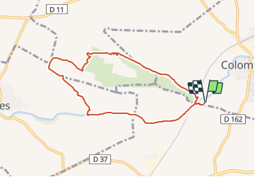
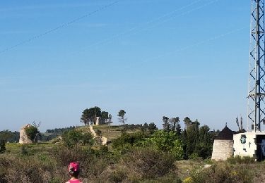
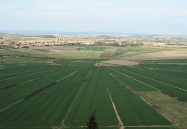
Ruta Senderismo de 8,5 km a descubrir en Occitania, Hérault, Colombiers. Esta ruta ha sido propuesta por jll7513.
Descripción
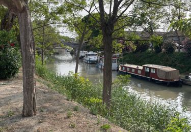
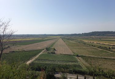
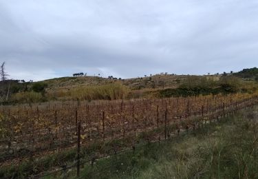
Petite boucle au départ du parking, on voit immédiatement la sortie du tunnel de Malpas, puis beau trajet en commençant par le bord du canal. Traversée du canal avec belle vue du pont et ensuite aprés la montée, vue sur l'étang très particulier de Montady, retour par la route au parking.
Localización
Comentarios
Excursiones cerca
![Excursión Senderismo Nissan-lez-Enserune - Nissan-les-Ensérune - Chapelle Saint-Christol - Moulins de Barral et de Tiquet - Photo](https://media.geolcdn.com/t/375/260/470ffdfc-c144-43e2-8481-bcc5745d5c96.jpg&format=jpg&maxdim=2)
![Senderismo Senderismo](https://static1.geolcdn.com/sitytour/trail-icons/101.png)
Senderismo
![](/images/other/stat-length.png)
![](https://static1.geolcdn.com/siteimages/upload/files/16400158638029165_repeat_loop_refresh_sync_direction_icon.png)
![Excursión Senderismo Nissan-lez-Enserune - les 3 moulins nissan - Photo](https://media.geolcdn.com/t/375/260/ext.jpg?maxdim=2&url=https%3A%2F%2Fstatic1.geolcdn.com%2Fsiteimages%2Fupload%2Ffiles%2F1553511878bg_sport_marche.png)
![Senderismo Senderismo](https://static1.geolcdn.com/sitytour/trail-icons/101.png)
Senderismo
![](/images/other/stat-length.png)
![](https://static1.geolcdn.com/siteimages/upload/files/16400158638029165_repeat_loop_refresh_sync_direction_icon.png)
![Excursión sport Nissan-lez-Enserune - Moulins Nissan circuit bleu - Photo](https://media.geolcdn.com/t/375/260/e12bc596-fb8e-4dc8-8fa8-2db96a217d41.jpg&format=jpg&maxdim=2)
sport
![](/images/other/stat-length.png)
![](https://static1.geolcdn.com/siteimages/upload/files/16400158638029165_repeat_loop_refresh_sync_direction_icon.png)
![Excursión Senderismo Poilhes - Berges du canal du midi à Poilhes - Photo](https://media.geolcdn.com/t/375/260/c7bb0444-4af3-42f6-9166-f97be7838fcb.jpg&format=jpg&maxdim=2)
![Senderismo Senderismo](https://static1.geolcdn.com/sitytour/trail-icons/101.png)
Senderismo
![](/images/other/stat-length.png)
![](https://static1.geolcdn.com/siteimages/upload/files/16400158638029165_repeat_loop_refresh_sync_direction_icon.png)
![Excursión Senderismo Nissan-lez-Enserune - chapelle St christol 3 Moulins par Domi et daron - Photo](https://media.geolcdn.com/t/375/260/3c591a00-04a4-46ae-aef1-348d38908cc6.jpg&format=jpg&maxdim=2)
![Senderismo Senderismo](https://static1.geolcdn.com/sitytour/trail-icons/101.png)
Senderismo
![](/images/other/stat-length.png)
![](https://static1.geolcdn.com/siteimages/upload/files/16400158638029165_repeat_loop_refresh_sync_direction_icon.png)
![Excursión Bici de montaña Colombiers - Oppidum Étang Montady - Photo](https://media.geolcdn.com/t/375/260/d74fff53-f3d8-499f-9780-0c4b42ff1b48.jpg&format=jpg&maxdim=2)
![Bici de montaña Bici de montaña](https://static1.geolcdn.com/sitytour/trail-icons/202.png)
Bici de montaña
![](/images/other/stat-length.png)
![](https://static1.geolcdn.com/siteimages/upload/files/16400158638029165_repeat_loop_refresh_sync_direction_icon.png)
![Excursión Senderismo Nissan-lez-Enserune - Nissan - Photo](https://media.geolcdn.com/t/375/260/a8974384-3e51-4656-9376-3a403403cfff.jpg&format=jpg&maxdim=2)
![Senderismo Senderismo](https://static1.geolcdn.com/sitytour/trail-icons/101.png)
Senderismo
![](/images/other/stat-length.png)
![](https://static1.geolcdn.com/siteimages/upload/files/16400158638029165_repeat_loop_refresh_sync_direction_icon.png)
![Excursión Senderismo Nissan-lez-Enserune - Nissan lez enserune de l'hôtel au patrimoine - Photo](https://media.geolcdn.com/t/375/260/ext.jpg?maxdim=2&url=https%3A%2F%2Fservices.sitytrail.com%2FGeolivesWS%2FDownloadMedia.ashx%3FTrailID%3D723094%26Media%3Dfix__20170330110936.jpg)
![Senderismo Senderismo](https://static1.geolcdn.com/sitytour/trail-icons/101.png)
Senderismo
![](/images/other/stat-length.png)
![](https://static1.geolcdn.com/siteimages/upload/files/16400158638029165_repeat_loop_refresh_sync_direction_icon.png)
![Excursión Senderismo Capestang - L'étang de Montady - Photo](https://media.geolcdn.com/t/375/260/ext.jpg?maxdim=2&url=https%3A%2F%2Fservices.sitytrail.com%2FGeolivesWS%2FDownloadMedia.ashx%3FTrailID%3D110169%26Media%3D5369_1.jpg)
![Senderismo Senderismo](https://static1.geolcdn.com/sitytour/trail-icons/101.png)
Senderismo
![](/images/other/stat-length.png)
![](https://static1.geolcdn.com/siteimages/upload/files/16400158638029165_repeat_loop_refresh_sync_direction_icon.png)