![](/images/other/stat-length.png)
![Excursión Senderismo Fournols - Les deux frères - Photo](https://media.geolcdn.com/t/1900/400/850e86b7-5776-4c3c-9003-306cd3798dc6.jpg&format=pjpeg&maxdim=2)
Les deux frères
Gegetop
Usuario
![Longitud](/images/other/stat-length.png)
![Altitud máxima](https://static1.geolcdn.com/siteimages/upload/files/1508320355ic_sort_altitude_max_24dp.png)
![Desnivel positivo](https://static1.geolcdn.com/siteimages/upload/files/1508320355ic_sort_den_pos_24dp.png)
![Km-Effort](/images/other/stat-length.png)
![Altitud mínima](https://static1.geolcdn.com/siteimages/upload/files/1508320355ic_sort_altitude_min_24dp.png)
![Desnivel negativo](https://static1.geolcdn.com/siteimages/upload/files/1508320355ic_sort_den_neg_24dp.png)
![Boucle](https://static1.geolcdn.com/siteimages/upload/files/16400158638029165_repeat_loop_refresh_sync_direction_icon.png)
![Senderismo](https://static1.geolcdn.com/sitytour/trail-icons/101.png)
4h15
Dificultad : Medio
![Marcha nórdica](https://static1.geolcdn.com/sitytour/trail-icons/102.png)
3h50
Dificultad : Medio
![Escanee este código QR para abrir la excursión en la aplicación SityTrail](https://capi.geolives.com/qq0zvz2zws4bq2lad0pu/sitytour/trails/2808673/qr.png?size=200)
Aplicación GPS de excursión GRATIS
A propósito
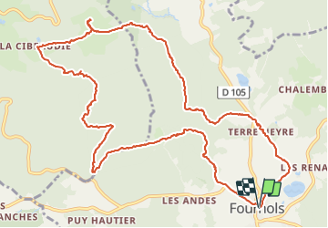
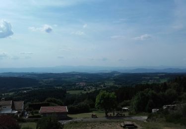
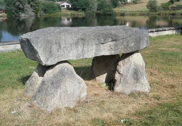
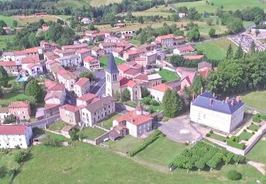
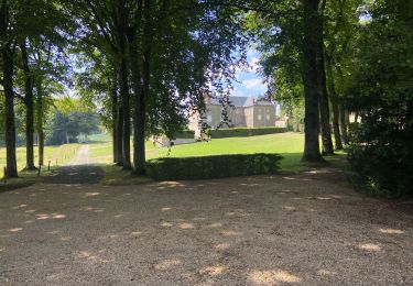
Ruta Senderismo de 14,8 km a descubrir en Auvergne-Rhône-Alpes, Puy-de-Dôme, Fournols. Esta ruta ha sido propuesta por Gegetop.
Descripción
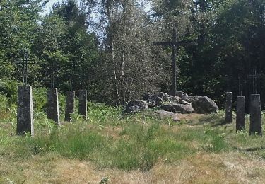
Randonnée n.45 de l'ancien guide Chamina.
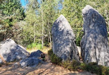
La forêt de Boigrand présente diverses essences resineuses, épicéa, mélèze, douglas mais aussi des feuillus hêtres, bouleau, sorbier, à lisier, saule cependant, l'essence principale reste le sapin dont certains dépassent 40m.
Localización
Comentarios
Excursiones cerca
![Excursión A pie Échandelys - Les Panoramas - Photo](https://media.geolcdn.com/t/375/260/b6c9543d-d4b0-4e45-81bf-a2b7f1258d7e.jpeg&format=jpg&maxdim=2)
![A pie A pie](https://static1.geolcdn.com/sitytour/trail-icons/100.png)
A pie
![](/images/other/stat-length.png)
![](https://static1.geolcdn.com/siteimages/upload/files/16400158638029165_repeat_loop_refresh_sync_direction_icon.png)
![Excursión A pie Saint-Amant-Roche-Savine - Roche-Savine - Photo](https://media.geolcdn.com/t/375/260/33e2b6f0-6c8c-409c-ab5f-7717ed153c10.jpeg&format=jpg&maxdim=2)
![A pie A pie](https://static1.geolcdn.com/sitytour/trail-icons/100.png)
A pie
![](/images/other/stat-length.png)
![](https://static1.geolcdn.com/siteimages/upload/files/16400158638029165_repeat_loop_refresh_sync_direction_icon.png)
![Excursión A pie Fournols - Les Deux-Frères - Photo](https://media.geolcdn.com/t/375/260/d5784189-973d-43a7-a97f-cca4aab8ee4e.jpeg&format=jpg&maxdim=2)
![A pie A pie](https://static1.geolcdn.com/sitytour/trail-icons/100.png)
A pie
![](/images/other/stat-length.png)
![](https://static1.geolcdn.com/siteimages/upload/files/16400158638029165_repeat_loop_refresh_sync_direction_icon.png)
![Excursión A pie Saint-Bonnet-le-Chastel - Frideroche - Photo](https://media.geolcdn.com/t/375/260/b327935d-e030-4733-947b-09de498f83c5.jpeg&format=jpg&maxdim=2)
![A pie A pie](https://static1.geolcdn.com/sitytour/trail-icons/100.png)
A pie
![](/images/other/stat-length.png)
![](https://static1.geolcdn.com/siteimages/upload/files/16400158638029165_repeat_loop_refresh_sync_direction_icon.png)
![Excursión A pie Fournols - Fournols - Puy du Sapt - Photo](https://media.geolcdn.com/t/375/260/bb2da9db-eba2-4b2a-a77a-8a634280fa0e.jpeg&format=jpg&maxdim=2)
![A pie A pie](https://static1.geolcdn.com/sitytour/trail-icons/100.png)
A pie
![](/images/other/stat-length.png)
![](https://static1.geolcdn.com/siteimages/upload/files/16400158638029165_repeat_loop_refresh_sync_direction_icon.png)
![Excursión Senderismo Échandelys - Echandelys_Panoramas - Photo](https://media.geolcdn.com/t/375/260/7ec13047-d9df-4116-9a4e-65cdef27f29f.jpg&format=jpg&maxdim=2)
![Senderismo Senderismo](https://static1.geolcdn.com/sitytour/trail-icons/101.png)
Senderismo
![](/images/other/stat-length.png)
![](https://static1.geolcdn.com/siteimages/upload/files/16400158638029165_repeat_loop_refresh_sync_direction_icon.png)
![Excursión Senderismo Échandelys - Panorama en Livradois-Forez - Photo](https://media.geolcdn.com/t/375/260/34db6a6d-9e7c-42d5-8fbe-73bdf7138b85.jpg&format=jpg&maxdim=2)
![Senderismo Senderismo](https://static1.geolcdn.com/sitytour/trail-icons/101.png)
Senderismo
![](/images/other/stat-length.png)
![](https://static1.geolcdn.com/siteimages/upload/files/16400158638029165_repeat_loop_refresh_sync_direction_icon.png)
![Excursión Senderismo Fournols - AUVERGNE 2023 Fournols - Les 2 frères - Photo](https://media.geolcdn.com/t/375/260/06e0f766-0d43-413d-a3a9-581028882a97.jpg&format=jpg&maxdim=2)
![Senderismo Senderismo](https://static1.geolcdn.com/sitytour/trail-icons/101.png)
Senderismo
![](/images/other/stat-length.png)
![](https://static1.geolcdn.com/siteimages/upload/files/16400158638029165_repeat_loop_refresh_sync_direction_icon.png)
![Excursión Senderismo Chambon-sur-Dolore - AUVERGNE 2023 Chambon-Frideroche - Photo](https://media.geolcdn.com/t/375/260/a4b0d336-9190-4c1a-b453-a0896104ecdd.jpg&format=jpg&maxdim=2)
![Senderismo Senderismo](https://static1.geolcdn.com/sitytour/trail-icons/101.png)
Senderismo
![](/images/other/stat-length.png)
![](https://static1.geolcdn.com/siteimages/upload/files/16400158638029165_repeat_loop_refresh_sync_direction_icon.png)