![](/images/other/stat-length.png)
Col des Bachassons depuis Romeyer
Philindy26
Usuario
![Longitud](/images/other/stat-length.png)
![Altitud máxima](https://static1.geolcdn.com/siteimages/upload/files/1508320355ic_sort_altitude_max_24dp.png)
![Desnivel positivo](https://static1.geolcdn.com/siteimages/upload/files/1508320355ic_sort_den_pos_24dp.png)
![Km-Effort](/images/other/stat-length.png)
![Altitud mínima](https://static1.geolcdn.com/siteimages/upload/files/1508320355ic_sort_altitude_min_24dp.png)
![Desnivel negativo](https://static1.geolcdn.com/siteimages/upload/files/1508320355ic_sort_den_neg_24dp.png)
![Boucle](https://static1.geolcdn.com/siteimages/upload/files/16400158638029165_repeat_loop_refresh_sync_direction_icon.png)
![Senderismo](https://static1.geolcdn.com/sitytour/trail-icons/101.png)
5h10
Dificultad : Difícil
![Escanee este código QR para abrir la excursión en la aplicación SityTrail](https://capi.geolives.com/qq0zvz2zws4bq2lad0pu/sitytour/trails/2806756/qr.png?size=200)
Aplicación GPS de excursión GRATIS
A propósito
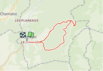
Ruta Senderismo de 17,2 km a descubrir en Auvergne-Rhône-Alpes, Drôme, Romeyer. Esta ruta ha sido propuesta por Philindy26.
Descripción
Départ du hameau des Liotards, commune de Romeyer dans le Diois…
Géolocalisation (Google Maps) : https://goo.gl/maps/hZ3PmVBTUqLUY4896
Monter au Col des Bachassons en suivant les marques Jaune/Vert et en prenant la direction du Brise Charge (529m), le Gué Déssableur (534m) puis le Ravin des Charoses pour arriver aux Charbonnières (1285m).
Au carrefour, tout droit montée finale au Col des Bachassons (1661m).
Descendre par le même chemin jusqu'aux Charbonnières.
Là prendre le sentier direction plein sud pour rejoindre Le Bichon (1118m).
Enfin descendre en direction du Gué Déssableur, Le Brise Charge et rejoindre le hameau des Liotards.
Localización
Comentarios
Excursiones cerca
![Excursión Bici de montaña Chamaloc - Chamaloc - Hauteurs de Die - Photo](https://media.geolcdn.com/t/375/260/ext.jpg?maxdim=2&url=https%3A%2F%2Fservices.sitytrail.com%2FGeolivesWS%2FDownloadMedia.ashx%3FTrailID%3D106987%26Media%3D11765_1.jpg)
![Bici de montaña Bici de montaña](https://static1.geolcdn.com/sitytour/trail-icons/202.png)
Bici de montaña
![](/images/other/stat-length.png)
![](https://static1.geolcdn.com/siteimages/upload/files/16400158638029165_repeat_loop_refresh_sync_direction_icon.png)
![Excursión Senderismo Romeyer - La rive du rocher des heures - Photo](https://media.geolcdn.com/t/375/260/86667611-d78a-47da-9447-751fb4cc13ca.jpg&format=jpg&maxdim=2)
![Senderismo Senderismo](https://static1.geolcdn.com/sitytour/trail-icons/101.png)
Senderismo
![](/images/other/stat-length.png)
![](https://static1.geolcdn.com/siteimages/upload/files/16400158638029165_repeat_loop_refresh_sync_direction_icon.png)
![Excursión Senderismo Romeyer - les rochers de plautret - Photo](https://media.geolcdn.com/t/375/260/ext.jpg?maxdim=2&url=https%3A%2F%2Fstatic1.geolcdn.com%2Fsiteimages%2Fupload%2Ffiles%2F1553511878bg_sport_marche.png)
![Senderismo Senderismo](https://static1.geolcdn.com/sitytour/trail-icons/101.png)
Senderismo
![](/images/other/stat-length.png)
![](https://static1.geolcdn.com/siteimages/upload/files/16400158638029165_repeat_loop_refresh_sync_direction_icon.png)
![Excursión sport Die - Val croissant comptoir des moutons - Photo](https://media.geolcdn.com/t/375/260/3b919326-2e50-400f-bc15-c6be506dcde0.jpg&format=jpg&maxdim=2)
sport
![](/images/other/stat-length.png)
![](https://static1.geolcdn.com/siteimages/upload/files/16400158638029165_repeat_loop_refresh_sync_direction_icon.png)
![Excursión Senderismo Marignac-en-Diois - Marignac - But de l'Aiglette - Col de Vassieux - Photo](https://media.geolcdn.com/t/375/260/bb473351-63e3-46f2-ae98-67f0e2c869f6.jpg&format=jpg&maxdim=2)
![Senderismo Senderismo](https://static1.geolcdn.com/sitytour/trail-icons/101.png)
Senderismo
![](/images/other/stat-length.png)
![](https://static1.geolcdn.com/siteimages/upload/files/16400158638029165_repeat_loop_refresh_sync_direction_icon.png)
![Excursión Senderismo Die - Col de Bergu - Photo](https://media.geolcdn.com/t/375/260/cd646939-5ef5-44d1-b09a-be899a9a43a7.jpg&format=jpg&maxdim=2)
![Senderismo Senderismo](https://static1.geolcdn.com/sitytour/trail-icons/101.png)
Senderismo
![](/images/other/stat-length.png)
![](https://static1.geolcdn.com/siteimages/upload/files/16400158638029165_repeat_loop_refresh_sync_direction_icon.png)
![Excursión Senderismo Die - Abbaye de Valcroissant - Photo](https://media.geolcdn.com/t/375/260/a9356d67-59c3-4251-97a5-c480f0ff70f4.jpg&format=jpg&maxdim=2)
![Senderismo Senderismo](https://static1.geolcdn.com/sitytour/trail-icons/101.png)
Senderismo
![](/images/other/stat-length.png)
![](https://static1.geolcdn.com/siteimages/upload/files/16400158638029165_repeat_loop_refresh_sync_direction_icon.png)
![Excursión Senderismo Romeyer - Romeyer - Col des Bachassons - Le Pison - Le Château - Photo](https://media.geolcdn.com/t/375/260/73561ee4-ea1d-48a2-8097-bbdb1d39c3b3.jpg&format=jpg&maxdim=2)
![Senderismo Senderismo](https://static1.geolcdn.com/sitytour/trail-icons/101.png)
Senderismo
![](/images/other/stat-length.png)
![](https://static1.geolcdn.com/siteimages/upload/files/16400158638029165_repeat_loop_refresh_sync_direction_icon.png)
![Excursión Senderismo Romeyer - Tourte-Barreaux - Photo](https://media.geolcdn.com/t/375/260/1088ac78-f0ff-4dec-abf8-a66b9ffd85bf.jpg&format=jpg&maxdim=2)
![Senderismo Senderismo](https://static1.geolcdn.com/sitytour/trail-icons/101.png)
Senderismo
![](/images/other/stat-length.png)
![](https://static1.geolcdn.com/siteimages/upload/files/16400158638029165_repeat_loop_refresh_sync_direction_icon.png)