![](/images/other/stat-length.png)
![Excursión Senderismo Winkel - Winkel-Petit Kohlberg_wpt_trk - Photo](https://media.geolcdn.com/t/1900/400/ext.pjpeg?maxdim=2&url=https%3A%2F%2Fstatic1.geolcdn.com%2Fsiteimages%2Fupload%2Ffiles%2F1553511878bg_sport_marche.png)
Winkel-Petit Kohlberg_wpt_trk
JCLUTT
Usuario
![Longitud](/images/other/stat-length.png)
Longitud
6,2 km
![Altitud máxima](https://static1.geolcdn.com/siteimages/upload/files/1508320355ic_sort_altitude_max_24dp.png)
Altitud máxima
791 m
![Desnivel positivo](https://static1.geolcdn.com/siteimages/upload/files/1508320355ic_sort_den_pos_24dp.png)
Desnivel positivo
148 m
![Km-Effort](/images/other/stat-length.png)
Km-Effort
8,2 km
![Altitud mínima](https://static1.geolcdn.com/siteimages/upload/files/1508320355ic_sort_altitude_min_24dp.png)
Altitud mínima
720 m
![Desnivel negativo](https://static1.geolcdn.com/siteimages/upload/files/1508320355ic_sort_den_neg_24dp.png)
Desnivel negativo
146 m
![Boucle](https://static1.geolcdn.com/siteimages/upload/files/16400158638029165_repeat_loop_refresh_sync_direction_icon.png)
Boucle
Sí
Fecha de creación :
2021-05-27 08:10:41.94
Última modificación :
2021-05-27 08:25:22.289
![Senderismo](https://static1.geolcdn.com/sitytour/trail-icons/101.png)
1h51
Dificultad : Muy fácil
![Escanee este código QR para abrir la excursión en la aplicación SityTrail](https://capi.geolives.com/qq0zvz2zws4bq2lad0pu/sitytour/trails/2803369/qr.png?size=200)
Aplicación GPS de excursión GRATIS
A propósito
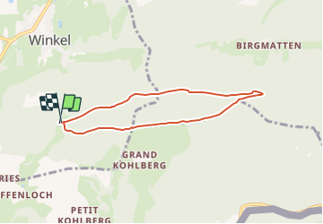
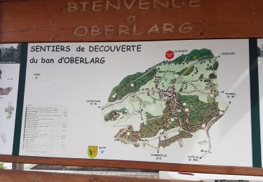
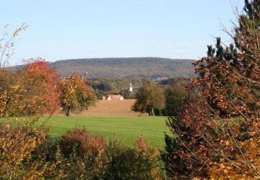
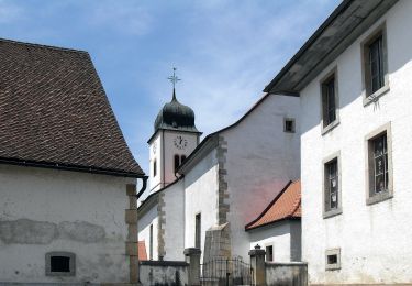
Ruta Senderismo de 6,2 km a descubrir en Gran Este, Alto Rin, Winkel. Esta ruta ha sido propuesta por JCLUTT.
Descripción
Petite balade apéritive ou digestive après un excellent repas au Petit Kohlberg ! A conseiller pour son accueil et la qualité du restaurant ! Ne pas oublier de faire un tour à la source de L'Ill et visiter la chapelle de Warth du 14ème siècle à Winkel.
Localización
País:
France
Región :
Gran Este
Departamento/provincia :
Alto Rin
Municipio :
Winkel
Localidad:
Unknown
Salida:(Dec)
Salida:(UTM)
369322 ; 5256625 (32T) N.
Comentarios
Excursiones cerca
![Excursión Senderismo Ferrette - Ferrette - Grotte des nains - Photo](https://media.geolcdn.com/t/375/260/ext.jpg?maxdim=2&url=https%3A%2F%2Fstatic1.geolcdn.com%2Fsiteimages%2Fupload%2Ffiles%2F1553511878bg_sport_marche.png)
![Senderismo Senderismo](https://static1.geolcdn.com/sitytour/trail-icons/101.png)
Ferrette - Grotte des nains
Senderismo
Fácil
(1)
Ferrette,
Gran Este,
Alto Rin,
France
![](/images/other/stat-length.png)
13,1 km | 21 km-effort
4h 0min
![](https://static1.geolcdn.com/siteimages/upload/files/16400158638029165_repeat_loop_refresh_sync_direction_icon.png)
Sí
![Excursión Senderismo Ferrette - Ferrette ,château, grotte des nains,rossberg - Photo](https://media.geolcdn.com/t/375/260/08efd9aa-9d0a-4420-acfb-5fad539ae3f9.jpg&format=jpg&maxdim=2)
![Senderismo Senderismo](https://static1.geolcdn.com/sitytour/trail-icons/101.png)
Ferrette ,château, grotte des nains,rossberg
Senderismo
Difícil
Ferrette,
Gran Este,
Alto Rin,
France
![](/images/other/stat-length.png)
8,6 km | 13,7 km-effort
5h 1min
![](https://static1.geolcdn.com/siteimages/upload/files/16400158638029165_repeat_loop_refresh_sync_direction_icon.png)
Sí
![Excursión Senderismo Levoncourt - Sortie les Copains d'abord.. 24/03/2022 - Photo](https://media.geolcdn.com/t/375/260/e59d3d7b-9ac7-43c7-934b-93ab50cd5556.jpg&format=jpg&maxdim=2)
![Senderismo Senderismo](https://static1.geolcdn.com/sitytour/trail-icons/101.png)
Sortie les Copains d'abord.. 24/03/2022
Senderismo
Medio
Levoncourt,
Gran Este,
Alto Rin,
France
![](/images/other/stat-length.png)
24 km | 34 km-effort
4h 57min
![](https://static1.geolcdn.com/siteimages/upload/files/16400158638029165_repeat_loop_refresh_sync_direction_icon.png)
Sí
![Excursión A pie Pleigne - Lucelle Douane - Pleigne - Photo](https://media.geolcdn.com/t/375/260/5e067c34-edcf-4a93-bd6c-7208fa7d1c3b.jpeg&format=jpg&maxdim=2)
![A pie A pie](https://static1.geolcdn.com/sitytour/trail-icons/100.png)
Lucelle Douane - Pleigne
A pie
Fácil
Pleigne,
Jura,
District de Delémont,
Switzerland
![](/images/other/stat-length.png)
5,3 km | 8 km-effort
1h 48min
![](https://static1.geolcdn.com/siteimages/upload/files/16400158638029165_repeat_loop_refresh_sync_direction_icon.png)
No
![Excursión Senderismo Oberlarg - Oberlarg - sa grotte - la ferme des Ebourbettes - le château de Morimont - Photo](https://media.geolcdn.com/t/375/260/12ac5782-f6dd-4515-a936-425ac3e33bf2.jpg&format=jpg&maxdim=2)
![Senderismo Senderismo](https://static1.geolcdn.com/sitytour/trail-icons/101.png)
Oberlarg - sa grotte - la ferme des Ebourbettes - le château de Morimont
Senderismo
Medio
Oberlarg,
Gran Este,
Alto Rin,
France
![](/images/other/stat-length.png)
9,5 km | 13,3 km-effort
3h 22min
![](https://static1.geolcdn.com/siteimages/upload/files/16400158638029165_repeat_loop_refresh_sync_direction_icon.png)
Sí
![Excursión Bicicleta Ferrette - La balade des étangs - Ferrette - Photo](https://media.geolcdn.com/t/375/260/ext.jpg?maxdim=2&url=https%3A%2F%2Fservices.sitytrail.com%2FGeolivesWS%2FDownloadMedia.ashx%3FTrailID%3D104300%26Media%3D7526_6.jpg)
![Bicicleta Bicicleta](https://static1.geolcdn.com/sitytour/trail-icons/200.png)
La balade des étangs - Ferrette
Bicicleta
Difícil
Ferrette,
Gran Este,
Alto Rin,
France
![](/images/other/stat-length.png)
59 km | 68 km-effort
3h 0min
![](https://static1.geolcdn.com/siteimages/upload/files/16400158638029165_repeat_loop_refresh_sync_direction_icon.png)
Sí
![Excursión A pie Pleigne - Sentier panoramique - Photo](https://media.geolcdn.com/t/375/260/ext.jpg?maxdim=2&url=https%3A%2F%2Fstatic1.geolcdn.com%2Fsiteimages%2Fupload%2Ffiles%2F1545311037marcheuse_200dpi.jpg)
![A pie A pie](https://static1.geolcdn.com/sitytour/trail-icons/100.png)
Sentier panoramique
A pie
Fácil
Pleigne,
Jura,
District de Delémont,
Switzerland
![](/images/other/stat-length.png)
5,7 km | 6,8 km-effort
1h 33min
![](https://static1.geolcdn.com/siteimages/upload/files/16400158638029165_repeat_loop_refresh_sync_direction_icon.png)
Sí
![Excursión A pie La Baroche - Pleujuse - fixme - Photo](https://media.geolcdn.com/t/375/260/ext.jpg?maxdim=2&url=https%3A%2F%2Fstatic1.geolcdn.com%2Fsiteimages%2Fupload%2Ffiles%2F1545311037marcheuse_200dpi.jpg)
![A pie A pie](https://static1.geolcdn.com/sitytour/trail-icons/100.png)
Pleujuse - fixme
A pie
Fácil
La Baroche,
Jura,
District de Porrentruy,
Switzerland
![](/images/other/stat-length.png)
3,1 km | 5,6 km-effort
1h 16min
![](https://static1.geolcdn.com/siteimages/upload/files/16400158638029165_repeat_loop_refresh_sync_direction_icon.png)
No
![Excursión A pie Pleigne - Pleigne - Bourrignon - Photo](https://media.geolcdn.com/t/375/260/33f5d971-2750-493f-8912-a7b1c456a54b.jpeg&format=jpg&maxdim=2)
![A pie A pie](https://static1.geolcdn.com/sitytour/trail-icons/100.png)
Pleigne - Bourrignon
A pie
Fácil
Pleigne,
Jura,
District de Delémont,
Switzerland
![](/images/other/stat-length.png)
4,9 km | 6,9 km-effort
1h 34min
![](https://static1.geolcdn.com/siteimages/upload/files/16400158638029165_repeat_loop_refresh_sync_direction_icon.png)
No