![](/images/other/stat-length.png)
![Excursión Senderismo Jaujac - Jaujac-Ventapet Serre-Rouge 14km. - Photo](https://media.geolcdn.com/t/1900/400/10c01bbf-ca52-4fd7-bee6-e78e2ab077af.jpg&format=pjpeg&maxdim=2)
Jaujac-Ventapet Serre-Rouge 14km.
chancha
Usuario GUIDE
![Longitud](/images/other/stat-length.png)
Longitud
14,2 km
![Altitud máxima](https://static1.geolcdn.com/siteimages/upload/files/1508320355ic_sort_altitude_max_24dp.png)
Altitud máxima
826 m
![Desnivel positivo](https://static1.geolcdn.com/siteimages/upload/files/1508320355ic_sort_den_pos_24dp.png)
Desnivel positivo
725 m
![Km-Effort](/images/other/stat-length.png)
Km-Effort
24 km
![Altitud mínima](https://static1.geolcdn.com/siteimages/upload/files/1508320355ic_sort_altitude_min_24dp.png)
Altitud mínima
371 m
![Desnivel negativo](https://static1.geolcdn.com/siteimages/upload/files/1508320355ic_sort_den_neg_24dp.png)
Desnivel negativo
725 m
![Boucle](https://static1.geolcdn.com/siteimages/upload/files/16400158638029165_repeat_loop_refresh_sync_direction_icon.png)
Boucle
Sí
Fecha de creación :
2021-05-25 08:48:10.946
Última modificación :
2025-02-12 11:02:23.187
![Senderismo](https://static1.geolcdn.com/sitytour/trail-icons/101.png)
5h25
Dificultad : Muy difícil
![Escanee este código QR para abrir la excursión en la aplicación SityTrail](https://capi.geolives.com/qq0zvz2zws4bq2lad0pu/sitytour/trails/2801480/qr.png?size=200)
Aplicación GPS de excursión GRATIS
A propósito
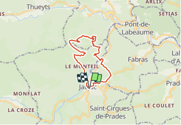
Ruta Senderismo de 14,2 km a descubrir en Auvergne-Rhône-Alpes, Ardecha, Jaujac. Esta ruta ha sido propuesta por chancha.
Descripción
Beaux Panorama. Ne pas hésiter a faire aller et retour jusqu’à la table interprétation de Serre-Rouge .
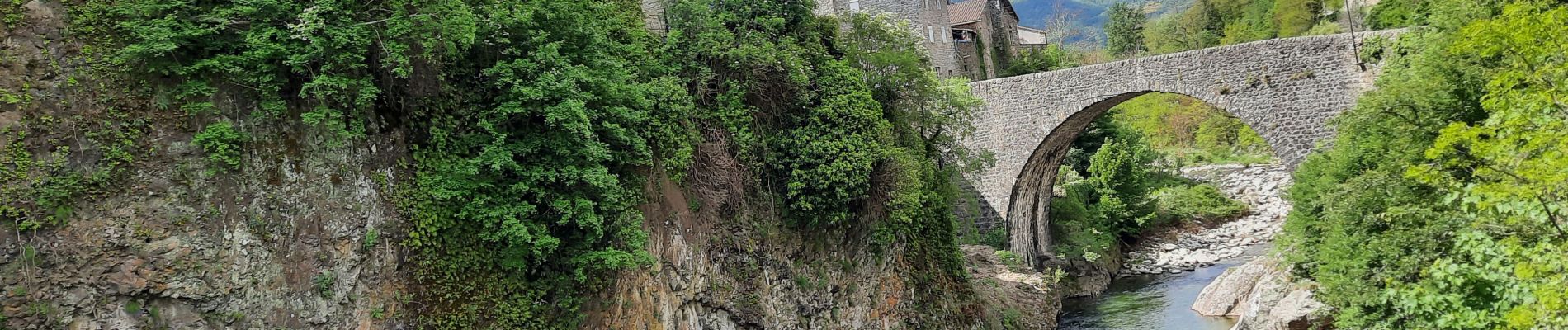
Jaujac et les Orgues Basaltiques.
Localización
País:
France
Región :
Auvergne-Rhône-Alpes
Departamento/provincia :
Ardecha
Municipio :
Jaujac
Localidad:
Unknown
Salida:(Dec)
Salida:(UTM)
599681 ; 4943202 (31T) N.
Comentarios
Excursiones cerca
![Excursión Senderismo Jaujac - Jaujac Le Ventapet 14km - Photo](https://media.geolcdn.com/t/375/260/6a0eb2eb-cf2c-4f85-a155-e7f0aba82db8.jpg&format=jpg&maxdim=2)
![Senderismo Senderismo](https://static1.geolcdn.com/sitytour/trail-icons/101.png)
Jaujac Le Ventapet 14km
Senderismo
Muy difícil
(1)
Jaujac,
Auvergne-Rhône-Alpes,
Ardecha,
France
![](/images/other/stat-length.png)
13,6 km | 23 km-effort
5h 18min
![](https://static1.geolcdn.com/siteimages/upload/files/16400158638029165_repeat_loop_refresh_sync_direction_icon.png)
Sí
![Excursión Senderismo Lentillères - Lentillières_les cretes_les Hameaux-13-02-17 - Photo](https://media.geolcdn.com/t/375/260/b26fd82a-80a8-4147-8d0f-0d41ac6326b3.jpg&format=jpg&maxdim=2)
![Senderismo Senderismo](https://static1.geolcdn.com/sitytour/trail-icons/101.png)
Lentillières_les cretes_les Hameaux-13-02-17
Senderismo
Muy fácil
(1)
Lentillères,
Auvergne-Rhône-Alpes,
Ardecha,
France
![](/images/other/stat-length.png)
12,2 km | 18,7 km-effort
3h 58min
![](https://static1.geolcdn.com/siteimages/upload/files/16400158638029165_repeat_loop_refresh_sync_direction_icon.png)
Sí
![Excursión Senderismo Fabras - Fabras - Photo](https://media.geolcdn.com/t/375/260/ext.jpg?maxdim=2&url=https%3A%2F%2Fstatic1.geolcdn.com%2Fsiteimages%2Fupload%2Ffiles%2F1553511878bg_sport_marche.png)
![Senderismo Senderismo](https://static1.geolcdn.com/sitytour/trail-icons/101.png)
Fabras
Senderismo
Medio
(1)
Fabras,
Auvergne-Rhône-Alpes,
Ardecha,
France
![](/images/other/stat-length.png)
6,4 km | 9,7 km-effort
1h 49min
![](https://static1.geolcdn.com/siteimages/upload/files/16400158638029165_repeat_loop_refresh_sync_direction_icon.png)
No
![Excursión Senderismo Jaujac - 07 jaujac rocher de l aigle - Photo](https://media.geolcdn.com/t/375/260/1a765c03-1770-4ba1-9c9c-9314823e934b.jpg&format=jpg&maxdim=2)
![Senderismo Senderismo](https://static1.geolcdn.com/sitytour/trail-icons/101.png)
07 jaujac rocher de l aigle
Senderismo
Fácil
(1)
Jaujac,
Auvergne-Rhône-Alpes,
Ardecha,
France
![](/images/other/stat-length.png)
11,2 km | 19,7 km-effort
6h 23min
![](https://static1.geolcdn.com/siteimages/upload/files/16400158638029165_repeat_loop_refresh_sync_direction_icon.png)
Sí
![Excursión Senderismo Meyras - neyrac les bains - Photo](https://media.geolcdn.com/t/375/260/ext.jpg?maxdim=2&url=https%3A%2F%2Fstatic1.geolcdn.com%2Fsiteimages%2Fupload%2Ffiles%2F1553511878bg_sport_marche.png)
![Senderismo Senderismo](https://static1.geolcdn.com/sitytour/trail-icons/101.png)
neyrac les bains
Senderismo
Fácil
(1)
Meyras,
Auvergne-Rhône-Alpes,
Ardecha,
France
![](/images/other/stat-length.png)
4,4 km | 6,8 km-effort
1h 36min
![](https://static1.geolcdn.com/siteimages/upload/files/16400158638029165_repeat_loop_refresh_sync_direction_icon.png)
Sí
![Excursión Senderismo Jaujac - ARDECHE, JAUJAC. .PONT DE L ECHELLE O - Photo](https://media.geolcdn.com/t/375/260/306eb66a-9a51-42c8-b3b4-a2c469fe7bd7.jpg&format=jpg&maxdim=2)
![Senderismo Senderismo](https://static1.geolcdn.com/sitytour/trail-icons/101.png)
ARDECHE, JAUJAC. .PONT DE L ECHELLE O
Senderismo
Medio
Jaujac,
Auvergne-Rhône-Alpes,
Ardecha,
France
![](/images/other/stat-length.png)
5,1 km | 8,3 km-effort
2h 33min
![](https://static1.geolcdn.com/siteimages/upload/files/16400158638029165_repeat_loop_refresh_sync_direction_icon.png)
No
![Excursión sport La Souche - De la Souche à Jaujac - Photo](https://media.geolcdn.com/t/375/260/3ee312a7-57c4-41b3-8f57-e35dcae92908.jpg&format=jpg&maxdim=2)
De la Souche à Jaujac
sport
Muy fácil
La Souche,
Auvergne-Rhône-Alpes,
Ardecha,
France
![](/images/other/stat-length.png)
13,3 km | 18 km-effort
Desconocido
![](https://static1.geolcdn.com/siteimages/upload/files/16400158638029165_repeat_loop_refresh_sync_direction_icon.png)
No
![Excursión Senderismo Jaujac - 07_jaujac_Orgues_9km360m - Photo](https://media.geolcdn.com/t/375/260/944ad327-537f-4f2c-8001-5010f7cb1f7d.jpg&format=jpg&maxdim=2)
![Senderismo Senderismo](https://static1.geolcdn.com/sitytour/trail-icons/101.png)
07_jaujac_Orgues_9km360m
Senderismo
Medio
Jaujac,
Auvergne-Rhône-Alpes,
Ardecha,
France
![](/images/other/stat-length.png)
9,1 km | 13,8 km-effort
3h 7min
![](https://static1.geolcdn.com/siteimages/upload/files/16400158638029165_repeat_loop_refresh_sync_direction_icon.png)
Sí
![Excursión Senderismo Thueyts - 231217 Thueyts-Brige - Photo](https://media.geolcdn.com/t/375/260/ext.jpg?maxdim=2&url=https%3A%2F%2Fstatic1.geolcdn.com%2Fsiteimages%2Fupload%2Ffiles%2F1553511878bg_sport_marche.png)
![Senderismo Senderismo](https://static1.geolcdn.com/sitytour/trail-icons/101.png)
231217 Thueyts-Brige
Senderismo
Fácil
(1)
Thueyts,
Auvergne-Rhône-Alpes,
Ardecha,
France
![](/images/other/stat-length.png)
5,7 km | 9,6 km-effort
2h 11min
![](https://static1.geolcdn.com/siteimages/upload/files/16400158638029165_repeat_loop_refresh_sync_direction_icon.png)
Sí