![](/images/other/stat-length.png)
![Excursión Senderismo Saint-Pierre-de-Trivisy - Le Garriguet Saint Pierre de Trivisy - Photo](https://media.geolcdn.com/t/1900/400/d1f5aa4e-49c4-48b2-b57f-51edce20a8b5.jpg&format=pjpeg&maxdim=2)
Le Garriguet Saint Pierre de Trivisy
tercla
Usuario
![Longitud](/images/other/stat-length.png)
Longitud
21 km
![Altitud máxima](https://static1.geolcdn.com/siteimages/upload/files/1508320355ic_sort_altitude_max_24dp.png)
Altitud máxima
715 m
![Desnivel positivo](https://static1.geolcdn.com/siteimages/upload/files/1508320355ic_sort_den_pos_24dp.png)
Desnivel positivo
753 m
![Km-Effort](/images/other/stat-length.png)
Km-Effort
31 km
![Altitud mínima](https://static1.geolcdn.com/siteimages/upload/files/1508320355ic_sort_altitude_min_24dp.png)
Altitud mínima
423 m
![Desnivel negativo](https://static1.geolcdn.com/siteimages/upload/files/1508320355ic_sort_den_neg_24dp.png)
Desnivel negativo
753 m
![Boucle](https://static1.geolcdn.com/siteimages/upload/files/16400158638029165_repeat_loop_refresh_sync_direction_icon.png)
Boucle
Sí
Fecha de creación :
2021-05-23 07:54:01.938
Última modificación :
2021-05-23 18:05:05.11
![Senderismo](https://static1.geolcdn.com/sitytour/trail-icons/101.png)
7h19
Dificultad : Difícil
![Escanee este código QR para abrir la excursión en la aplicación SityTrail](https://capi.geolives.com/qq0zvz2zws4bq2lad0pu/sitytour/trails/2798829/qr.png?size=200)
Aplicación GPS de excursión GRATIS
A propósito
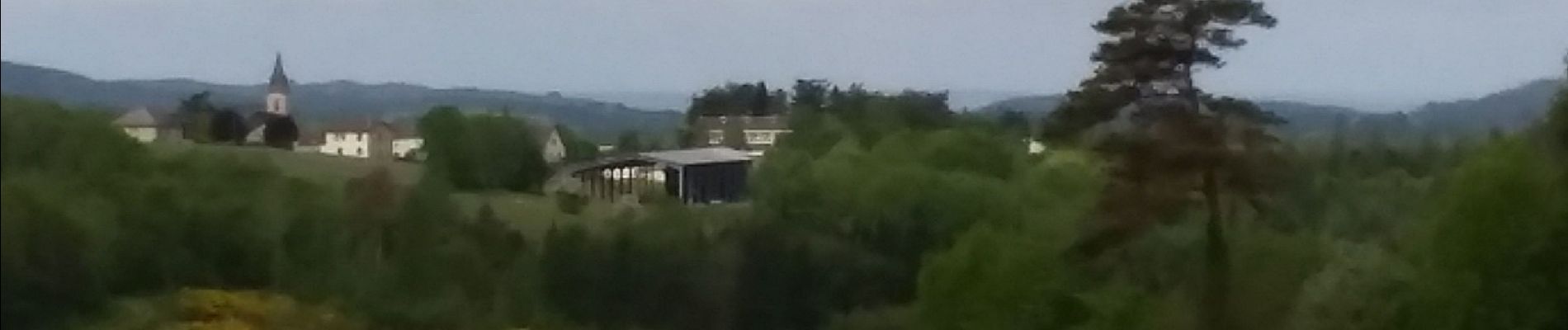
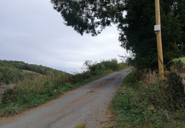
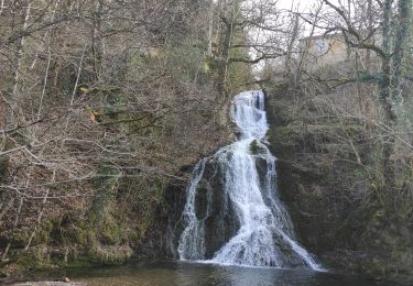
Ruta Senderismo de 21 km a descubrir en Occitania, Tarn, Saint-Pierre-de-Trivisy. Esta ruta ha sido propuesta por tercla.
Descripción
Pacours tres vallonnè avec des trew beau points de vues et passage en forêts
Localización
País:
France
Región :
Occitania
Departamento/provincia :
Tarn
Municipio :
Saint-Pierre-de-Trivisy
Localidad:
Unknown
Salida:(Dec)
Salida:(UTM)
455943 ; 4844904 (31T) N.
Comentarios
Excursiones cerca
![Excursión Senderismo Montredon-Labessonnié - Sur les pas de nos ancêtres - Photo](https://media.geolcdn.com/t/375/260/4fb0ef7c-a1b5-4fca-a7a8-202ba9f23ac1.jpg&format=jpg&maxdim=2)
![Senderismo Senderismo](https://static1.geolcdn.com/sitytour/trail-icons/101.png)
Sur les pas de nos ancêtres
Senderismo
Fácil
Montredon-Labessonnié,
Occitania,
Tarn,
France
![](/images/other/stat-length.png)
8,5 km | 12,5 km-effort
2h 6min
![](https://static1.geolcdn.com/siteimages/upload/files/16400158638029165_repeat_loop_refresh_sync_direction_icon.png)
Sí
![Excursión Senderismo Lacaze - Roquecave - Photo](https://media.geolcdn.com/t/375/260/c071a83a-62b2-41cf-a753-8ed31b882d13.jpg&format=jpg&maxdim=2)
![Senderismo Senderismo](https://static1.geolcdn.com/sitytour/trail-icons/101.png)
![Excursión Senderismo Saint-Pierre-de-Trivisy - Le moulin de Broussonié (avec variante) - Photo](https://media.geolcdn.com/t/375/260/ext.jpg?maxdim=2&url=https%3A%2F%2Fstatic1.geolcdn.com%2Fsiteimages%2Fupload%2Ffiles%2F1553511878bg_sport_marche.png)
![Senderismo Senderismo](https://static1.geolcdn.com/sitytour/trail-icons/101.png)
Le moulin de Broussonié (avec variante)
Senderismo
Medio
Saint-Pierre-de-Trivisy,
Occitania,
Tarn,
France
![](/images/other/stat-length.png)
11,4 km | 16,3 km-effort
2h 23min
![](https://static1.geolcdn.com/siteimages/upload/files/16400158638029165_repeat_loop_refresh_sync_direction_icon.png)
Sí
![Excursión Senderismo Saint-Pierre-de-Trivisy - 81_Saint_Pierre de Trivisy_longue_préreco - Photo](https://media.geolcdn.com/t/375/260/ext.jpg?maxdim=2&url=https%3A%2F%2Fstatic1.geolcdn.com%2Fsiteimages%2Fupload%2Ffiles%2F1553511878bg_sport_marche.png)
![Senderismo Senderismo](https://static1.geolcdn.com/sitytour/trail-icons/101.png)
81_Saint_Pierre de Trivisy_longue_préreco
Senderismo
Difícil
Saint-Pierre-de-Trivisy,
Occitania,
Tarn,
France
![](/images/other/stat-length.png)
16,8 km | 23 km-effort
5h 23min
![](https://static1.geolcdn.com/siteimages/upload/files/16400158638029165_repeat_loop_refresh_sync_direction_icon.png)
Sí
![Excursión Senderismo Lacaze - 81_Lacaze_Gijou_long - Photo](https://media.geolcdn.com/t/375/260/ext.jpg?maxdim=2&url=https%3A%2F%2Fstatic1.geolcdn.com%2Fsiteimages%2Fupload%2Ffiles%2F1553511878bg_sport_marche.png)
![Senderismo Senderismo](https://static1.geolcdn.com/sitytour/trail-icons/101.png)
81_Lacaze_Gijou_long
Senderismo
Difícil
Lacaze,
Occitania,
Tarn,
France
![](/images/other/stat-length.png)
16,7 km | 26 km-effort
4h 22min
![](https://static1.geolcdn.com/siteimages/upload/files/16400158638029165_repeat_loop_refresh_sync_direction_icon.png)
Sí
![Excursión Senderismo Lacaze - 81_Masnau_court - Photo](https://media.geolcdn.com/t/375/260/ext.jpg?maxdim=2&url=https%3A%2F%2Fstatic1.geolcdn.com%2Fsiteimages%2Fupload%2Ffiles%2F1553511878bg_sport_marche.png)
![Senderismo Senderismo](https://static1.geolcdn.com/sitytour/trail-icons/101.png)
81_Masnau_court
Senderismo
Medio
Lacaze,
Occitania,
Tarn,
France
![](/images/other/stat-length.png)
14,1 km | 19,8 km-effort
4h 21min
![](https://static1.geolcdn.com/siteimages/upload/files/16400158638029165_repeat_loop_refresh_sync_direction_icon.png)
Sí
![Excursión Senderismo Saint-Pierre-de-Trivisy - 81_saint pierre de trivisy_nord - Photo](https://media.geolcdn.com/t/375/260/ext.jpg?maxdim=2&url=https%3A%2F%2Fstatic1.geolcdn.com%2Fsiteimages%2Fupload%2Ffiles%2F1553511878bg_sport_marche.png)
![Senderismo Senderismo](https://static1.geolcdn.com/sitytour/trail-icons/101.png)
81_saint pierre de trivisy_nord
Senderismo
Difícil
Saint-Pierre-de-Trivisy,
Occitania,
Tarn,
France
![](/images/other/stat-length.png)
9,8 km | 14,2 km-effort
3h 13min
![](https://static1.geolcdn.com/siteimages/upload/files/16400158638029165_repeat_loop_refresh_sync_direction_icon.png)
Sí
![Excursión Senderismo Saint-Pierre-de-Trivisy - 81_saint_pierre_de_trivisy_courte_prereco - Photo](https://media.geolcdn.com/t/375/260/ext.jpg?maxdim=2&url=https%3A%2F%2Fstatic1.geolcdn.com%2Fsiteimages%2Fupload%2Ffiles%2F1553511878bg_sport_marche.png)
![Senderismo Senderismo](https://static1.geolcdn.com/sitytour/trail-icons/101.png)
81_saint_pierre_de_trivisy_courte_prereco
Senderismo
Muy difícil
Saint-Pierre-de-Trivisy,
Occitania,
Tarn,
France
![](/images/other/stat-length.png)
13,9 km | 19,2 km-effort
4h 22min
![](https://static1.geolcdn.com/siteimages/upload/files/16400158638029165_repeat_loop_refresh_sync_direction_icon.png)
Sí
![Excursión Senderismo Lacaze - lacaze à saint jean del frech - Photo](https://media.geolcdn.com/t/375/260/ext.jpg?maxdim=2&url=https%3A%2F%2Fstatic1.geolcdn.com%2Fsiteimages%2Fupload%2Ffiles%2F1553511878bg_sport_marche.png)
![Senderismo Senderismo](https://static1.geolcdn.com/sitytour/trail-icons/101.png)
lacaze à saint jean del frech
Senderismo
Medio
Lacaze,
Occitania,
Tarn,
France
![](/images/other/stat-length.png)
23 km | 33 km-effort
7h 11min
![](https://static1.geolcdn.com/siteimages/upload/files/16400158638029165_repeat_loop_refresh_sync_direction_icon.png)
Sí