![](/images/other/stat-length.png)
![Excursión Senderismo Touffreville - Touffreville - Rosay sur Lieure - Photo](https://media.geolcdn.com/t/1900/400/10927830-4a09-41fd-8fce-d1bcd8092a8b.jpg&format=pjpeg&maxdim=2)
Touffreville - Rosay sur Lieure
Marie-Claire-mcp
Usuario
![Longitud](/images/other/stat-length.png)
Longitud
11,6 km
![Altitud máxima](https://static1.geolcdn.com/siteimages/upload/files/1508320355ic_sort_altitude_max_24dp.png)
Altitud máxima
171 m
![Desnivel positivo](https://static1.geolcdn.com/siteimages/upload/files/1508320355ic_sort_den_pos_24dp.png)
Desnivel positivo
277 m
![Km-Effort](/images/other/stat-length.png)
Km-Effort
15,2 km
![Altitud mínima](https://static1.geolcdn.com/siteimages/upload/files/1508320355ic_sort_altitude_min_24dp.png)
Altitud mínima
61 m
![Desnivel negativo](https://static1.geolcdn.com/siteimages/upload/files/1508320355ic_sort_den_neg_24dp.png)
Desnivel negativo
272 m
![Boucle](https://static1.geolcdn.com/siteimages/upload/files/16400158638029165_repeat_loop_refresh_sync_direction_icon.png)
Boucle
Sí
Fecha de creación :
2021-05-20 06:50:23.334
Última modificación :
2023-09-20 14:46:22.225
![Senderismo](https://static1.geolcdn.com/sitytour/trail-icons/101.png)
3h09
Dificultad : Difícil
![Escanee este código QR para abrir la excursión en la aplicación SityTrail](https://capi.geolives.com/qq0zvz2zws4bq2lad0pu/sitytour/trails/2793804/qr.png?size=200)
Aplicación GPS de excursión GRATIS
A propósito
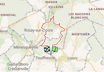
Ruta Senderismo de 11,6 km a descubrir en Normandía, Eure, Touffreville. Esta ruta ha sido propuesta por Marie-Claire-mcp.
Descripción
Touffreville - Rosay sur Lieure
Localización
País:
France
Región :
Normandía
Departamento/provincia :
Eure
Municipio :
Touffreville
Localidad:
Unknown
Salida:(Dec)
Salida:(UTM)
387042 ; 5467862 (31U) N.
Comentarios
Excursiones cerca
![Excursión Marcha nórdica Lyons-la-Forêt - MN 66 L'Essart Mador - Photo](https://media.geolcdn.com/t/375/260/ext.jpg?maxdim=2&url=https%3A%2F%2Fstatic1.geolcdn.com%2Fsiteimages%2Fupload%2Ffiles%2F1545311037marcheuse_200dpi.jpg)
![Marcha nórdica Marcha nórdica](https://static1.geolcdn.com/sitytour/trail-icons/102.png)
MN 66 L'Essart Mador
Marcha nórdica
Fácil
(2)
Lyons-la-Forêt,
Normandía,
Eure,
France
![](/images/other/stat-length.png)
8,9 km | 10,8 km-effort
1h 30min
![](https://static1.geolcdn.com/siteimages/upload/files/16400158638029165_repeat_loop_refresh_sync_direction_icon.png)
Sí
![Excursión Marcha nórdica Rosay-sur-Lieure - Marche Nordique 59 Rosay sur Lieure - Photo](https://media.geolcdn.com/t/375/260/ext.jpg?maxdim=2&url=https%3A%2F%2Fstatic1.geolcdn.com%2Fsiteimages%2Fupload%2Ffiles%2F1545311037marcheuse_200dpi.jpg)
![Marcha nórdica Marcha nórdica](https://static1.geolcdn.com/sitytour/trail-icons/102.png)
Marche Nordique 59 Rosay sur Lieure
Marcha nórdica
Medio
(1)
Rosay-sur-Lieure,
Normandía,
Eure,
France
![](/images/other/stat-length.png)
9,2 km | 10,9 km-effort
1h 30min
![](https://static1.geolcdn.com/siteimages/upload/files/16400158638029165_repeat_loop_refresh_sync_direction_icon.png)
Sí
![Excursión Senderismo Rosay-sur-Lieure - Rando Douce 1 - Rosay sur Lieure - Photo](https://media.geolcdn.com/t/375/260/ext.jpg?maxdim=2&url=https%3A%2F%2Fstatic1.geolcdn.com%2Fsiteimages%2Fupload%2Ffiles%2F1553511878bg_sport_marche.png)
![Senderismo Senderismo](https://static1.geolcdn.com/sitytour/trail-icons/101.png)
Rando Douce 1 - Rosay sur Lieure
Senderismo
Medio
(1)
Rosay-sur-Lieure,
Normandía,
Eure,
France
![](/images/other/stat-length.png)
6,2 km | 7,6 km-effort
2h 0min
![](https://static1.geolcdn.com/siteimages/upload/files/16400158638029165_repeat_loop_refresh_sync_direction_icon.png)
Sí
![Excursión Senderismo Rosay-sur-Lieure - Rosay-sur-Lieure - vers Charleval - Photo](https://media.geolcdn.com/t/375/260/ext.jpg?maxdim=2&url=https%3A%2F%2Fstatic1.geolcdn.com%2Fsiteimages%2Fupload%2Ffiles%2F1553511878bg_sport_marche.png)
![Senderismo Senderismo](https://static1.geolcdn.com/sitytour/trail-icons/101.png)
Rosay-sur-Lieure - vers Charleval
Senderismo
Fácil
(1)
Rosay-sur-Lieure,
Normandía,
Eure,
France
![](/images/other/stat-length.png)
9,4 km | 11,6 km-effort
3h 1min
![](https://static1.geolcdn.com/siteimages/upload/files/16400158638029165_repeat_loop_refresh_sync_direction_icon.png)
Sí
![Excursión Senderismo Ménesqueville - Ménesqueville - Gaillardbois - Photo](https://media.geolcdn.com/t/375/260/ext.jpg?maxdim=2&url=https%3A%2F%2Fstatic1.geolcdn.com%2Fsiteimages%2Fupload%2Ffiles%2F1553511878bg_sport_marche.png)
![Senderismo Senderismo](https://static1.geolcdn.com/sitytour/trail-icons/101.png)
Ménesqueville - Gaillardbois
Senderismo
Fácil
(2)
Ménesqueville,
Normandía,
Eure,
France
![](/images/other/stat-length.png)
11,7 km | 13,9 km-effort
3h 19min
![](https://static1.geolcdn.com/siteimages/upload/files/16400158638029165_repeat_loop_refresh_sync_direction_icon.png)
Sí
![Excursión Senderismo Lyons-la-Forêt - L'Essart Mador - Les taisnières - Photo](https://media.geolcdn.com/t/375/260/ext.jpg?maxdim=2&url=https%3A%2F%2Fstatic1.geolcdn.com%2Fsiteimages%2Fupload%2Ffiles%2F1553511878bg_sport_marche.png)
![Senderismo Senderismo](https://static1.geolcdn.com/sitytour/trail-icons/101.png)
L'Essart Mador - Les taisnières
Senderismo
Fácil
(1)
Lyons-la-Forêt,
Normandía,
Eure,
France
![](/images/other/stat-length.png)
8 km | 10 km-effort
2h 12min
![](https://static1.geolcdn.com/siteimages/upload/files/16400158638029165_repeat_loop_refresh_sync_direction_icon.png)
Sí
![Excursión Senderismo Lyons-la-Forêt - Foret de Lyons - Les Veneurs 1 - Photo](https://media.geolcdn.com/t/375/260/ext.jpg?maxdim=2&url=https%3A%2F%2Fstatic1.geolcdn.com%2Fsiteimages%2Fupload%2Ffiles%2F1553511878bg_sport_marche.png)
![Senderismo Senderismo](https://static1.geolcdn.com/sitytour/trail-icons/101.png)
Foret de Lyons - Les Veneurs 1
Senderismo
Fácil
(1)
Lyons-la-Forêt,
Normandía,
Eure,
France
![](/images/other/stat-length.png)
10,3 km | 12,9 km-effort
3h 13min
![](https://static1.geolcdn.com/siteimages/upload/files/16400158638029165_repeat_loop_refresh_sync_direction_icon.png)
Sí
![Excursión Senderismo Lyons-la-Forêt - Foret de Lyons - Les Veneurs 2 - Photo](https://media.geolcdn.com/t/375/260/ext.jpg?maxdim=2&url=https%3A%2F%2Fstatic1.geolcdn.com%2Fsiteimages%2Fupload%2Ffiles%2F1553511878bg_sport_marche.png)
![Senderismo Senderismo](https://static1.geolcdn.com/sitytour/trail-icons/101.png)
Foret de Lyons - Les Veneurs 2
Senderismo
Muy fácil
(1)
Lyons-la-Forêt,
Normandía,
Eure,
France
![](/images/other/stat-length.png)
8,4 km | 10,9 km-effort
2h 25min
![](https://static1.geolcdn.com/siteimages/upload/files/16400158638029165_repeat_loop_refresh_sync_direction_icon.png)
Sí
![Excursión Senderismo Touffreville - Touffreville - Sentier de la Jacassière - Photo](https://media.geolcdn.com/t/375/260/ext.jpg?maxdim=2&url=https%3A%2F%2Fstatic1.geolcdn.com%2Fsiteimages%2Fupload%2Ffiles%2F1553511878bg_sport_marche.png)
![Senderismo Senderismo](https://static1.geolcdn.com/sitytour/trail-icons/101.png)
Touffreville - Sentier de la Jacassière
Senderismo
Medio
(2)
Touffreville,
Normandía,
Eure,
France
![](/images/other/stat-length.png)
10,9 km | 14,5 km-effort
3h 8min
![](https://static1.geolcdn.com/siteimages/upload/files/16400158638029165_repeat_loop_refresh_sync_direction_icon.png)
Sí