![](/images/other/stat-length.png)
![Excursión Senderismo Montaud - La Dent de Moirans - Photo](https://media.geolcdn.com/t/1900/400/42159542-0525-485e-906a-e99c0c2c152d.jpg&format=pjpeg&maxdim=2)
La Dent de Moirans
patjobou
Usuario
![Longitud](/images/other/stat-length.png)
Longitud
11 km
![Altitud máxima](https://static1.geolcdn.com/siteimages/upload/files/1508320355ic_sort_altitude_max_24dp.png)
Altitud máxima
990 m
![Desnivel positivo](https://static1.geolcdn.com/siteimages/upload/files/1508320355ic_sort_den_pos_24dp.png)
Desnivel positivo
406 m
![Km-Effort](/images/other/stat-length.png)
Km-Effort
16,4 km
![Altitud mínima](https://static1.geolcdn.com/siteimages/upload/files/1508320355ic_sort_altitude_min_24dp.png)
Altitud mínima
670 m
![Desnivel negativo](https://static1.geolcdn.com/siteimages/upload/files/1508320355ic_sort_den_neg_24dp.png)
Desnivel negativo
406 m
![Boucle](https://static1.geolcdn.com/siteimages/upload/files/16400158638029165_repeat_loop_refresh_sync_direction_icon.png)
Boucle
Sí
Fecha de creación :
2021-05-13 08:35:43.37
Última modificación :
2021-05-13 17:58:24.518
![Senderismo](https://static1.geolcdn.com/sitytour/trail-icons/101.png)
4h38
Dificultad : Fácil
![Escanee este código QR para abrir la excursión en la aplicación SityTrail](https://capi.geolives.com/qq0zvz2zws4bq2lad0pu/sitytour/trails/2785072/qr.png?size=200)
Aplicación GPS de excursión GRATIS
A propósito
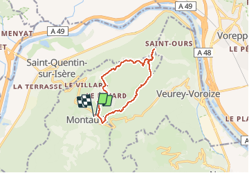
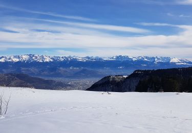
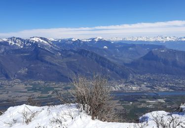
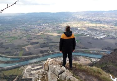
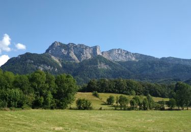
Ruta Senderismo de 11 km a descubrir en Auvergne-Rhône-Alpes, Isère, Montaud. Esta ruta ha sido propuesta por patjobou.
Descripción
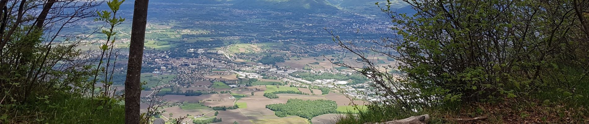
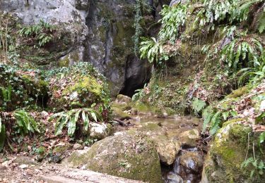
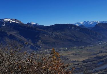
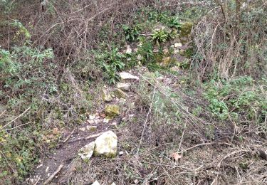
Belle boucle sans difficulté, dans une belle forêt de feuillus. Parcours sur le vieux sentiers empierrés. Dommage qu'ils soient partiellement endommagés par des travaux forestiers. Souhaitons qu'ils soient remis en état.
Localización
País:
France
Región :
Auvergne-Rhône-Alpes
Departamento/provincia :
Isère
Municipio :
Montaud
Localidad:
Unknown
Salida:(Dec)
Salida:(UTM)
701343 ; 5015562 (31T) N.
Comentarios
Excursiones cerca
![Excursión Senderismo Voreppe - 38 voreppe - Photo](https://media.geolcdn.com/t/375/260/ae534631-eaae-45ff-8bde-8ca8e28aadbe.jpg&format=jpg&maxdim=2)
![Senderismo Senderismo](https://static1.geolcdn.com/sitytour/trail-icons/101.png)
38 voreppe
Senderismo
Medio
Voreppe,
Auvergne-Rhône-Alpes,
Isère,
France
![](/images/other/stat-length.png)
8,7 km | 16,8 km-effort
6h 25min
![](https://static1.geolcdn.com/siteimages/upload/files/16400158638029165_repeat_loop_refresh_sync_direction_icon.png)
Sí
![Excursión Senderismo Saint-Quentin-sur-Isère - 38 St Quentin sur isere - Photo](https://media.geolcdn.com/t/375/260/a8213203-4838-4b30-a9a1-6f63f9fa0c7f.jpg&format=jpg&maxdim=2)
![Senderismo Senderismo](https://static1.geolcdn.com/sitytour/trail-icons/101.png)
38 St Quentin sur isere
Senderismo
Medio
Saint-Quentin-sur-Isère,
Auvergne-Rhône-Alpes,
Isère,
France
![](/images/other/stat-length.png)
17 km | 28 km-effort
7h 22min
![](https://static1.geolcdn.com/siteimages/upload/files/16400158638029165_repeat_loop_refresh_sync_direction_icon.png)
Sí
![Excursión Senderismo Voreppe - le trou au loup - Photo](https://media.geolcdn.com/t/375/260/4be90cdf-26f4-4d2a-b22f-02f0baa87490.jpg&format=jpg&maxdim=2)
![Senderismo Senderismo](https://static1.geolcdn.com/sitytour/trail-icons/101.png)
le trou au loup
Senderismo
Difícil
Voreppe,
Auvergne-Rhône-Alpes,
Isère,
France
![](/images/other/stat-length.png)
8,5 km | 16,5 km-effort
6h 29min
![](https://static1.geolcdn.com/siteimages/upload/files/16400158638029165_repeat_loop_refresh_sync_direction_icon.png)
Sí
![Excursión Senderismo Saint-Quentin-sur-Isère - Dent de Moirans - Photo](https://media.geolcdn.com/t/375/260/cc5b3296-26ad-4d08-b80e-e1eedf7283f6.jpg&format=jpg&maxdim=2)
![Senderismo Senderismo](https://static1.geolcdn.com/sitytour/trail-icons/101.png)
Dent de Moirans
Senderismo
Muy difícil
Saint-Quentin-sur-Isère,
Auvergne-Rhône-Alpes,
Isère,
France
![](/images/other/stat-length.png)
14,7 km | 26 km-effort
6h 17min
![](https://static1.geolcdn.com/siteimages/upload/files/16400158638029165_repeat_loop_refresh_sync_direction_icon.png)
Sí
![Excursión Senderismo Saint-Quentin-sur-Isère - 38 carrières echaillon - Photo](https://media.geolcdn.com/t/375/260/728d4589-2ee2-49ea-a83d-3257b1bf0904.jpg&format=jpg&maxdim=2)
![Senderismo Senderismo](https://static1.geolcdn.com/sitytour/trail-icons/101.png)
38 carrières echaillon
Senderismo
Difícil
Saint-Quentin-sur-Isère,
Auvergne-Rhône-Alpes,
Isère,
France
![](/images/other/stat-length.png)
2,4 km | 4,5 km-effort
2h 55min
![](https://static1.geolcdn.com/siteimages/upload/files/16400158638029165_repeat_loop_refresh_sync_direction_icon.png)
Sí
![Excursión Raquetas de nieve Autrans-Méaudre en Vercors - La Grande Brèche - La Buffe - La Sure (2022) - Photo](https://media.geolcdn.com/t/375/260/0ed3592b-52f6-40cf-babc-f54ce22268ca.jpg&format=jpg&maxdim=2)
![Raquetas de nieve Raquetas de nieve](https://static1.geolcdn.com/sitytour/trail-icons/504.png)
La Grande Brèche - La Buffe - La Sure (2022)
Raquetas de nieve
Medio
Autrans-Méaudre en Vercors,
Auvergne-Rhône-Alpes,
Isère,
France
![](/images/other/stat-length.png)
12,9 km | 22 km-effort
4h 28min
![](https://static1.geolcdn.com/siteimages/upload/files/16400158638029165_repeat_loop_refresh_sync_direction_icon.png)
Sí
![Excursión Senderismo Autrans-Méaudre en Vercors - boucle la Buffe - la Sure - Photo](https://media.geolcdn.com/t/375/260/9d650f75-523f-40ee-a83c-0bfaf17ae3cc.jpg&format=jpg&maxdim=2)
![Senderismo Senderismo](https://static1.geolcdn.com/sitytour/trail-icons/101.png)
boucle la Buffe - la Sure
Senderismo
Difícil
Autrans-Méaudre en Vercors,
Auvergne-Rhône-Alpes,
Isère,
France
![](/images/other/stat-length.png)
8,6 km | 16,1 km-effort
4h 52min
![](https://static1.geolcdn.com/siteimages/upload/files/16400158638029165_repeat_loop_refresh_sync_direction_icon.png)
Sí
![Excursión Senderismo Montaud - La dent de Moirans - Photo](https://media.geolcdn.com/t/375/260/c31d5ba7-98c1-4d2c-8f51-1281362b0eb5.jpg&format=jpg&maxdim=2)
![Senderismo Senderismo](https://static1.geolcdn.com/sitytour/trail-icons/101.png)
La dent de Moirans
Senderismo
Muy fácil
(1)
Montaud,
Auvergne-Rhône-Alpes,
Isère,
France
![](/images/other/stat-length.png)
8,9 km | 13,5 km-effort
2h 57min
![](https://static1.geolcdn.com/siteimages/upload/files/16400158638029165_repeat_loop_refresh_sync_direction_icon.png)
Sí
![Excursión Senderismo Montaud - BOUCLE MONTAUD DE T DE MOIRANS - Photo](https://media.geolcdn.com/t/375/260/e130ea2b-4587-4c00-ae7c-a57eb66385d6.jpg&format=jpg&maxdim=2)
![Senderismo Senderismo](https://static1.geolcdn.com/sitytour/trail-icons/101.png)
BOUCLE MONTAUD DE T DE MOIRANS
Senderismo
Medio
Montaud,
Auvergne-Rhône-Alpes,
Isère,
France
![](/images/other/stat-length.png)
11,1 km | 16,7 km-effort
3h 12min
![](https://static1.geolcdn.com/siteimages/upload/files/16400158638029165_repeat_loop_refresh_sync_direction_icon.png)
Sí