![](/images/other/stat-length.png)
![Excursión A pie Trédrez-Locquémeau - Brie-Cte-Robert - Photo](https://media.geolcdn.com/t/1900/400/ext.pjpeg?maxdim=2&url=https%3A%2F%2Fstatic1.geolcdn.com%2Fsiteimages%2Fupload%2Ffiles%2F1545311037marcheuse_200dpi.jpg)
Brie-Cte-Robert
aucamus
Usuario
![Longitud](/images/other/stat-length.png)
![Altitud máxima](https://static1.geolcdn.com/siteimages/upload/files/1508320355ic_sort_altitude_max_24dp.png)
![Desnivel positivo](https://static1.geolcdn.com/siteimages/upload/files/1508320355ic_sort_den_pos_24dp.png)
![Km-Effort](/images/other/stat-length.png)
![Altitud mínima](https://static1.geolcdn.com/siteimages/upload/files/1508320355ic_sort_altitude_min_24dp.png)
![Desnivel negativo](https://static1.geolcdn.com/siteimages/upload/files/1508320355ic_sort_den_neg_24dp.png)
![Boucle](https://static1.geolcdn.com/siteimages/upload/files/16400158638029165_repeat_loop_refresh_sync_direction_icon.png)
![A pie](https://static1.geolcdn.com/sitytour/trail-icons/100.png)
6h44
Dificultad : Medio
![Escanee este código QR para abrir la excursión en la aplicación SityTrail](https://capi.geolives.com/qq0zvz2zws4bq2lad0pu/sitytour/trails/2780766/qr.png?size=200)
Aplicación GPS de excursión GRATIS
A propósito
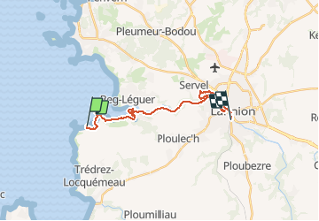
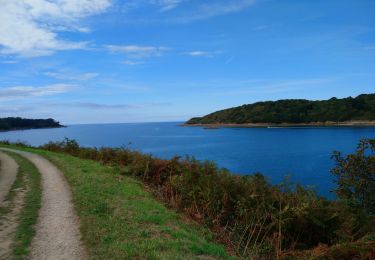
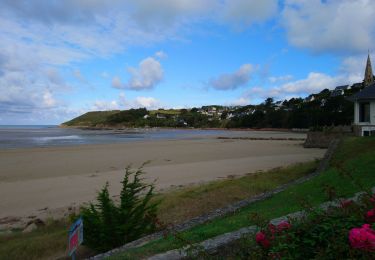
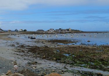
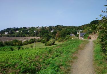
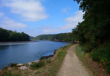
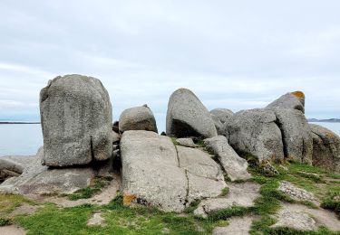
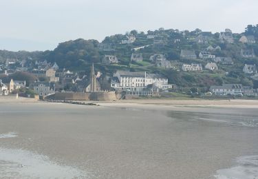
Ruta A pie de 17,8 km a descubrir en Bretaña, Côtes-d'Armor, Trédrez-Locquémeau. Esta ruta ha sido propuesta por aucamus.
Descripción
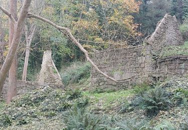
Brie-Cte-Robert - Parking gratuit Place des Fêtes
27km via Grisy-Suisnes, Coubert, Soignolles et Evry-Grégy
Aperçu de Brie (Eglise St Etienne, Château médiéval, Chemin des Roses), Grisy Suisnes (Beffroi, Gare), Coubert, Soignolles (rives de l'Yerres), Prieuré de Venelles, Evry-Grégy (Pont des Romains).
Localización
Comentarios
Excursiones cerca
![Excursión Senderismo Ploulec'h - le Yaudet - GR34 Locquémeau - 9.4km 220m 2h30 - 2023 09 11 - Photo](https://media.geolcdn.com/t/375/260/2eeb17d1-bab0-475d-9575-f8db3e07c699.jpg&format=jpg&maxdim=2)
![Senderismo Senderismo](https://static1.geolcdn.com/sitytour/trail-icons/101.png)
Senderismo
![](/images/other/stat-length.png)
![](https://static1.geolcdn.com/siteimages/upload/files/16400158638029165_repeat_loop_refresh_sync_direction_icon.png)
![Excursión Senderismo Saint-Michel-en-Grève - Saint-Michel-en-Grève - GR34 Beg ar Forn Église - 7.7km 200m 2h15 (50mn) - 2023 09 13 - Photo](https://media.geolcdn.com/t/375/260/bd360931-dba5-41e4-8b43-2e110bb983db.jpg&format=jpg&maxdim=2)
![Senderismo Senderismo](https://static1.geolcdn.com/sitytour/trail-icons/101.png)
Senderismo
![](/images/other/stat-length.png)
![](https://static1.geolcdn.com/siteimages/upload/files/16400158638029165_repeat_loop_refresh_sync_direction_icon.png)
![Excursión Senderismo Trédrez-Locquémeau - Locquémeau - GR34 Trédez - 12km 210m 3h30 (40mn) - 2023 09 12 - Photo](https://media.geolcdn.com/t/375/260/d045c6d2-b69e-45a3-8904-ac3f903b1140.jpg&format=jpg&maxdim=2)
![Senderismo Senderismo](https://static1.geolcdn.com/sitytour/trail-icons/101.png)
Senderismo
![](/images/other/stat-length.png)
![](https://static1.geolcdn.com/siteimages/upload/files/16400158638029165_repeat_loop_refresh_sync_direction_icon.png)
![Excursión Senderismo Trébeurden - Trébeurden - Porz Mabo GR34 - 6.6km 165m 1h50 (40mn) - 2023 09 04 - Photo](https://media.geolcdn.com/t/375/260/4f4a5121-d670-4014-a780-e42da8e62161.jpg&format=jpg&maxdim=2)
![Senderismo Senderismo](https://static1.geolcdn.com/sitytour/trail-icons/101.png)
Senderismo
![](/images/other/stat-length.png)
![](https://static1.geolcdn.com/siteimages/upload/files/16400158638029165_repeat_loop_refresh_sync_direction_icon.png)
![Excursión Senderismo Trébeurden - Trébeurden - Croaz Golo GR34A GR34 - 15.1km 320m 4h15 (50mn) - 2023 09 03 - Photo](https://media.geolcdn.com/t/375/260/1a08cc2b-a6d7-4306-885a-2253f395737e.jpg&format=jpg&maxdim=2)
![Senderismo Senderismo](https://static1.geolcdn.com/sitytour/trail-icons/101.png)
Senderismo
![](/images/other/stat-length.png)
![](https://static1.geolcdn.com/siteimages/upload/files/16400158638029165_repeat_loop_refresh_sync_direction_icon.png)
![Excursión Senderismo Trédrez-Locquémeau - Bretagne nord J7 / De Locquémeau à Lannion - Photo](https://media.geolcdn.com/t/375/260/8aae618b-25b0-4c49-81a5-2065b569b6ca.jpg&format=jpg&maxdim=2)
![Senderismo Senderismo](https://static1.geolcdn.com/sitytour/trail-icons/101.png)
Senderismo
![](/images/other/stat-length.png)
![](https://static1.geolcdn.com/siteimages/upload/files/16400158638029165_repeat_loop_refresh_sync_direction_icon.png)
![Excursión Senderismo Saint-Michel-en-Grève - Bretagne nord J6pm : St Michel en Grève - Locquémau - Photo](https://media.geolcdn.com/t/375/260/5addfac7-c616-4bd4-a226-cf31118124b4.jpg&format=jpg&maxdim=2)
![Senderismo Senderismo](https://static1.geolcdn.com/sitytour/trail-icons/101.png)
Senderismo
![](/images/other/stat-length.png)
![](https://static1.geolcdn.com/siteimages/upload/files/16400158638029165_repeat_loop_refresh_sync_direction_icon.png)
![Excursión Senderismo Ploulec'h - GR_34_EE_33_Ploulech_St-Michel-En-Greve_20241104 - Photo](https://media.geolcdn.com/t/375/260/2e9eb71c-2891-49ed-aa31-8d3210d67c07.jpg&format=jpg&maxdim=2)
![Senderismo Senderismo](https://static1.geolcdn.com/sitytour/trail-icons/101.png)
Senderismo
![](/images/other/stat-length.png)
![](https://static1.geolcdn.com/siteimages/upload/files/16400158638029165_repeat_loop_refresh_sync_direction_icon.png)
![Excursión Senderismo Trébeurden - GR_34_ED_32_Trebeurden_Ploulech_20241103 - Photo](https://media.geolcdn.com/t/375/260/bfd8f62a-b62e-455b-9475-994ca3fe1e84.jpg&format=jpg&maxdim=2)
![Senderismo Senderismo](https://static1.geolcdn.com/sitytour/trail-icons/101.png)
Senderismo
![](/images/other/stat-length.png)
![](https://static1.geolcdn.com/siteimages/upload/files/16400158638029165_repeat_loop_refresh_sync_direction_icon.png)