![](/images/other/stat-length.png)
![Excursión Senderismo Voeren - Ulvend (Fourons-St-Martin) - Photo](https://media.geolcdn.com/t/1900/400/96d45a53-600d-45a1-a03d-bd9e1d057c81.jpg&format=pjpeg&maxdim=2)
Ulvend (Fourons-St-Martin)
mumu.larandonneuse
Usuario GUIDE
![Longitud](/images/other/stat-length.png)
Longitud
12,5 km
![Altitud máxima](https://static1.geolcdn.com/siteimages/upload/files/1508320355ic_sort_altitude_max_24dp.png)
Altitud máxima
247 m
![Desnivel positivo](https://static1.geolcdn.com/siteimages/upload/files/1508320355ic_sort_den_pos_24dp.png)
Desnivel positivo
208 m
![Km-Effort](/images/other/stat-length.png)
Km-Effort
15,3 km
![Altitud mínima](https://static1.geolcdn.com/siteimages/upload/files/1508320355ic_sort_altitude_min_24dp.png)
Altitud mínima
124 m
![Desnivel negativo](https://static1.geolcdn.com/siteimages/upload/files/1508320355ic_sort_den_neg_24dp.png)
Desnivel negativo
207 m
![Boucle](https://static1.geolcdn.com/siteimages/upload/files/16400158638029165_repeat_loop_refresh_sync_direction_icon.png)
Boucle
Sí
Fecha de creación :
2021-04-30 11:20:15.933
Última modificación :
2021-04-30 15:27:04.934
![Senderismo](https://static1.geolcdn.com/sitytour/trail-icons/101.png)
2h44
Dificultad : Fácil
![Escanee este código QR para abrir la excursión en la aplicación SityTrail](https://capi.geolives.com/qq0zvz2zws4bq2lad0pu/sitytour/trails/2767451/qr.png?size=200)
Aplicación GPS de excursión GRATIS
A propósito
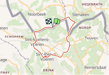
Ruta Senderismo de 12,5 km a descubrir en Flandes, Limburgo, Voeren. Esta ruta ha sido propuesta por mumu.larandonneuse.
Descripción
Superbe boucle campagnarde balisée avec les points-noeuds.
📌 Glacier 't Bakhuis.
✅ Suivre : 68 51 50 49 48 91 47 55 60 62 63 64 65 74 73 72 71 70 69 68.
Localización
País:
Belgium
Región :
Flandes
Departamento/provincia :
Limburgo
Municipio :
Voeren
Localidad:
Sint-Martens-Voeren
Salida:(Dec)
Salida:(UTM)
699607 ; 5626787 (31U) N.
Comentarios
Excursiones cerca
![Excursión Senderismo Eijsden-Margraten - 2024-07-15_17h32m47_eijsden-margraten-mh1-altenbroek - Photo](https://media.geolcdn.com/t/375/260/1dd6d074-f00f-48cf-a4e6-d95117778ebf.jpg&format=jpg&maxdim=2)
![Senderismo Senderismo](https://static1.geolcdn.com/sitytour/trail-icons/101.png)
2024-07-15_17h32m47_eijsden-margraten-mh1-altenbroek
Senderismo
Medio
(1)
Eijsden-Margraten,
Limburgo,
Desconocido,
Netherlands
![](/images/other/stat-length.png)
8,8 km | 11 km-effort
2h 29min
![](https://static1.geolcdn.com/siteimages/upload/files/16400158638029165_repeat_loop_refresh_sync_direction_icon.png)
Sí
![Excursión Senderismo Eijsden-Margraten - Mheer - Banholt - Hoogbos - Photo](https://media.geolcdn.com/t/375/260/1f70cdf1-9a0b-4d25-acc7-7c75993bbb86.jpg&format=jpg&maxdim=2)
![Senderismo Senderismo](https://static1.geolcdn.com/sitytour/trail-icons/101.png)
Mheer - Banholt - Hoogbos
Senderismo
Medio
(1)
Eijsden-Margraten,
Limburgo,
Desconocido,
Netherlands
![](/images/other/stat-length.png)
12,5 km | 14,5 km-effort
3h 4min
![](https://static1.geolcdn.com/siteimages/upload/files/16400158638029165_repeat_loop_refresh_sync_direction_icon.png)
Sí
![Excursión Senderismo Voeren - Amstel Gold Race 2024 🚲 - Photo](https://media.geolcdn.com/t/375/260/bca146f7-0c03-4970-a3ca-ea328283e994.jpg&format=jpg&maxdim=2)
![Senderismo Senderismo](https://static1.geolcdn.com/sitytour/trail-icons/101.png)
Amstel Gold Race 2024 🚲
Senderismo
Medio
(1)
Voeren,
Flandes,
Limburgo,
Belgium
![](/images/other/stat-length.png)
11,7 km | 14,9 km-effort
3h 23min
![](https://static1.geolcdn.com/siteimages/upload/files/16400158638029165_repeat_loop_refresh_sync_direction_icon.png)
Sí
![Excursión Senderismo Voeren - Ulvend - La Planck - Noorbeek - Photo](https://media.geolcdn.com/t/375/260/1b8a3af4-c436-4943-b8e2-3197209c6144.jpg&format=jpg&maxdim=2)
![Senderismo Senderismo](https://static1.geolcdn.com/sitytour/trail-icons/101.png)
Ulvend - La Planck - Noorbeek
Senderismo
Fácil
(1)
Voeren,
Flandes,
Limburgo,
Belgium
![](/images/other/stat-length.png)
17 km | 22 km-effort
4h 57min
![](https://static1.geolcdn.com/siteimages/upload/files/16400158638029165_repeat_loop_refresh_sync_direction_icon.png)
Sí
![Excursión Senderismo Voeren - 2022-11-11_17h35m36_wandelroute-de-voerstreek-mooiste - Photo](https://media.geolcdn.com/t/375/260/3df743f8-88e4-4c10-a47a-c05fdf0072fe.jpg&format=jpg&maxdim=2)
![Senderismo Senderismo](https://static1.geolcdn.com/sitytour/trail-icons/101.png)
2022-11-11_17h35m36_wandelroute-de-voerstreek-mooiste
Senderismo
Medio
(1)
Voeren,
Flandes,
Limburgo,
Belgium
![](/images/other/stat-length.png)
9,3 km | 12,5 km-effort
2h 49min
![](https://static1.geolcdn.com/siteimages/upload/files/16400158638029165_repeat_loop_refresh_sync_direction_icon.png)
Sí
![Excursión Senderismo Voeren - La Commanderie 7 - Photo](https://media.geolcdn.com/t/375/260/e2b67305-0779-4cca-9070-82e3402cc790.jpg&format=jpg&maxdim=2)
![Senderismo Senderismo](https://static1.geolcdn.com/sitytour/trail-icons/101.png)
La Commanderie 7
Senderismo
Fácil
(1)
Voeren,
Flandes,
Limburgo,
Belgium
![](/images/other/stat-length.png)
4,5 km | 6,3 km-effort
1h 26min
![](https://static1.geolcdn.com/siteimages/upload/files/16400158638029165_repeat_loop_refresh_sync_direction_icon.png)
Sí
![Excursión Senderismo Dalhem - 2021-10-21_18h00m54_1397 - Photo](https://media.geolcdn.com/t/375/260/9e5bb66b-83f0-45b1-bd6f-be4253f11322.jpg&format=jpg&maxdim=2)
![Senderismo Senderismo](https://static1.geolcdn.com/sitytour/trail-icons/101.png)
2021-10-21_18h00m54_1397
Senderismo
Medio
(2)
Dalhem,
Valonia,
Lieja,
Belgium
![](/images/other/stat-length.png)
13,9 km | 17,6 km-effort
3h 59min
![](https://static1.geolcdn.com/siteimages/upload/files/16400158638029165_repeat_loop_refresh_sync_direction_icon.png)
Sí
![Excursión Senderismo Voeren - 2021-10-13_17h01m13_fouron-le-comte - Photo](https://media.geolcdn.com/t/375/260/e05bdacf-e910-4818-b0aa-de5529cdf1e8.jpg&format=jpg&maxdim=2)
![Senderismo Senderismo](https://static1.geolcdn.com/sitytour/trail-icons/101.png)
2021-10-13_17h01m13_fouron-le-comte
Senderismo
Fácil
(1)
Voeren,
Flandes,
Limburgo,
Belgium
![](/images/other/stat-length.png)
14,5 km | 16,9 km-effort
3h 50min
![](https://static1.geolcdn.com/siteimages/upload/files/16400158638029165_repeat_loop_refresh_sync_direction_icon.png)
Sí
![Excursión Senderismo Eijsden-Margraten - 2021-06-19_19h26m43_031 - Photo](https://media.geolcdn.com/t/375/260/136c3226-85ca-4638-b449-da2a119d703c.jpg&format=jpg&maxdim=2)
![Senderismo Senderismo](https://static1.geolcdn.com/sitytour/trail-icons/101.png)
2021-06-19_19h26m43_031
Senderismo
Fácil
(1)
Eijsden-Margraten,
Limburgo,
Desconocido,
Netherlands
![](/images/other/stat-length.png)
13,3 km | 15,7 km-effort
3h 34min
![](https://static1.geolcdn.com/siteimages/upload/files/16400158638029165_repeat_loop_refresh_sync_direction_icon.png)
Sí