![](/images/other/stat-length.png)
![Excursión Senderismo Treffléan - SityTrail - Treffléan (Bizole - Randrécart - Barrage de Trégat) - Photo](https://media.geolcdn.com/t/1900/400/ext.pjpeg?maxdim=2&url=https%3A%2F%2Fstatic1.geolcdn.com%2Fsiteimages%2Fupload%2Ffiles%2F1553511878bg_sport_marche.png)
SityTrail - Treffléan (Bizole - Randrécart - Barrage de Trégat)
PAM2235
Usuario
![Longitud](/images/other/stat-length.png)
Longitud
10,7 km
![Altitud máxima](https://static1.geolcdn.com/siteimages/upload/files/1508320355ic_sort_altitude_max_24dp.png)
Altitud máxima
113 m
![Desnivel positivo](https://static1.geolcdn.com/siteimages/upload/files/1508320355ic_sort_den_pos_24dp.png)
Desnivel positivo
208 m
![Km-Effort](/images/other/stat-length.png)
Km-Effort
13,5 km
![Altitud mínima](https://static1.geolcdn.com/siteimages/upload/files/1508320355ic_sort_altitude_min_24dp.png)
Altitud mínima
47 m
![Desnivel negativo](https://static1.geolcdn.com/siteimages/upload/files/1508320355ic_sort_den_neg_24dp.png)
Desnivel negativo
207 m
![Boucle](https://static1.geolcdn.com/siteimages/upload/files/16400158638029165_repeat_loop_refresh_sync_direction_icon.png)
Boucle
Sí
Fecha de creación :
2021-04-22 17:30:16.414
Última modificación :
2021-04-25 17:51:41.316
![Senderismo](https://static1.geolcdn.com/sitytour/trail-icons/101.png)
2h40
Dificultad : Difícil
![Escanee este código QR para abrir la excursión en la aplicación SityTrail](https://capi.geolives.com/qq0zvz2zws4bq2lad0pu/sitytour/trails/2757921/qr.png?size=200)
Aplicación GPS de excursión GRATIS
A propósito
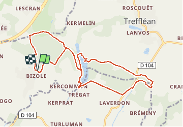
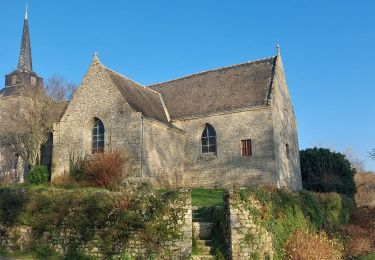
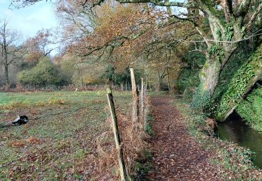
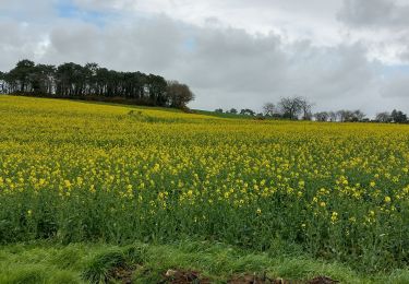
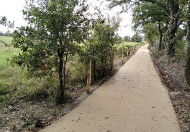
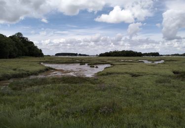
Ruta Senderismo de 10,7 km a descubrir en Bretaña, Morbihan, Treffléan. Esta ruta ha sido propuesta por PAM2235.
Descripción
Circuit de 9,6 km au départ du parking situé au chevet de la chapelle de Bizole. Cette variante du circuit de Bizole permet de découvrir le barrage de Trégat.
Localización
País:
France
Región :
Bretaña
Departamento/provincia :
Morbihan
Municipio :
Treffléan
Localidad:
Unknown
Salida:(Dec)
Salida:(UTM)
526382 ; 5279722 (30T) N.
Comentarios
Excursiones cerca
![Excursión Senderismo Treffléan - Bizole - Photo](https://media.geolcdn.com/t/375/260/ext.jpg?maxdim=2&url=https%3A%2F%2Fservices.sitytrail.com%2FGeolivesWS%2FDownloadMedia.ashx%3FTrailID%3D191920%26Media%3Dfb5fe928-9f5d-4af5-aad3-ccb04a0144c1.JPG)
![Senderismo Senderismo](https://static1.geolcdn.com/sitytour/trail-icons/101.png)
![Excursión Senderismo Treffléan - PR_56_Trefflean_BA_02_Circuit1b_Chemin-De-Cran_20240507 - Photo](https://media.geolcdn.com/t/375/260/ext.jpg?maxdim=2&url=https%3A%2F%2Fmedia.geolcdn.com%2Ff%2Fb832eb83-9ae2-4127-a1d1-f2e6e6666b1a.jpg)
![Senderismo Senderismo](https://static1.geolcdn.com/sitytour/trail-icons/101.png)
PR_56_Trefflean_BA_02_Circuit1b_Chemin-De-Cran_20240507
Senderismo
Fácil
Treffléan,
Bretaña,
Morbihan,
France
![](/images/other/stat-length.png)
5,4 km | 6,5 km-effort
1h 12min
![](https://static1.geolcdn.com/siteimages/upload/files/16400158638029165_repeat_loop_refresh_sync_direction_icon.png)
Sí
![Excursión Senderismo Saint-Nolff - PR_56_St-Nolf_AB_02_Circuit1b_De-La-Vallee-Du-Condat_20240119 - Photo](https://media.geolcdn.com/t/375/260/ext.jpg?maxdim=2&url=https%3A%2F%2Fmedia.geolcdn.com%2Ff%2F0e42b6aa-72a8-47c5-a4ef-d03dd001716a.jpg)
![Senderismo Senderismo](https://static1.geolcdn.com/sitytour/trail-icons/101.png)
PR_56_St-Nolf_AB_02_Circuit1b_De-La-Vallee-Du-Condat_20240119
Senderismo
Fácil
Saint-Nolff,
Bretaña,
Morbihan,
France
![](/images/other/stat-length.png)
12,4 km | 15,1 km-effort
2h 31min
![](https://static1.geolcdn.com/siteimages/upload/files/16400158638029165_repeat_loop_refresh_sync_direction_icon.png)
Sí
![Excursión Senderismo Treffléan - PR_56_Trefflean_AA_01_Circuit1b_De-La-Chapelle-De-Bizole_20240111 - Photo](https://media.geolcdn.com/t/375/260/ext.jpg?maxdim=2&url=https%3A%2F%2Fmedia.geolcdn.com%2Ff%2F33cdd34a-a9e1-478f-975c-2bd4facddb06.jpg)
![Senderismo Senderismo](https://static1.geolcdn.com/sitytour/trail-icons/101.png)
PR_56_Trefflean_AA_01_Circuit1b_De-La-Chapelle-De-Bizole_20240111
Senderismo
Medio
Treffléan,
Bretaña,
Morbihan,
France
![](/images/other/stat-length.png)
6,4 km | 8,2 km-effort
1h 20min
![](https://static1.geolcdn.com/siteimages/upload/files/16400158638029165_repeat_loop_refresh_sync_direction_icon.png)
Sí
![Excursión Senderismo Saint-Nolff - PR_56_St-Nolf_AA_01_Circuit1b-Court_De-La-Vallee-Du-Condat_20231119 - Photo](https://media.geolcdn.com/t/375/260/ext.jpg?maxdim=2&url=https%3A%2F%2Fmedia.geolcdn.com%2Ff%2F2b53e2b9-cdcb-4572-9474-136823668337.jpg)
![Senderismo Senderismo](https://static1.geolcdn.com/sitytour/trail-icons/101.png)
PR_56_St-Nolf_AA_01_Circuit1b-Court_De-La-Vallee-Du-Condat_20231119
Senderismo
Medio
Saint-Nolff,
Bretaña,
Morbihan,
France
![](/images/other/stat-length.png)
7,6 km | 9 km-effort
1h 31min
![](https://static1.geolcdn.com/siteimages/upload/files/16400158638029165_repeat_loop_refresh_sync_direction_icon.png)
Sí
![Excursión Senderismo Theix-Noyalo - PR_56_Theix-Noyalo_AA_01_Circuit3b_Vers-Corn-Er-Hoet_20230401 - Photo](https://media.geolcdn.com/t/375/260/ext.jpg?maxdim=2&url=https%3A%2F%2Fmedia.geolcdn.com%2Ff%2F53a27219-59ef-468a-9654-2c8ca963d998.jpg)
![Senderismo Senderismo](https://static1.geolcdn.com/sitytour/trail-icons/101.png)
PR_56_Theix-Noyalo_AA_01_Circuit3b_Vers-Corn-Er-Hoet_20230401
Senderismo
Medio
Theix-Noyalo,
Bretaña,
Morbihan,
France
![](/images/other/stat-length.png)
8,3 km | 9,9 km-effort
1h 40min
![](https://static1.geolcdn.com/siteimages/upload/files/16400158638029165_repeat_loop_refresh_sync_direction_icon.png)
Sí
![Excursión Bici de montaña Theix-Noyalo - 56-vtt-theix-ambon-26km - Photo](https://media.geolcdn.com/t/375/260/ext.jpg?maxdim=2&url=https%3A%2F%2Fmedia.geolcdn.com%2Ff%2Feaaae4e6-3ad5-4e2c-842f-c8c95c871393.jpg)
![Bici de montaña Bici de montaña](https://static1.geolcdn.com/sitytour/trail-icons/202.png)
56-vtt-theix-ambon-26km
Bici de montaña
Fácil
(1)
Theix-Noyalo,
Bretaña,
Morbihan,
France
![](/images/other/stat-length.png)
27 km | 29 km-effort
1h 51min
![](https://static1.geolcdn.com/siteimages/upload/files/16400158638029165_repeat_loop_refresh_sync_direction_icon.png)
Sí
![Excursión Bici de montaña Theix-Noyalo - 56-vtt-theix-le-hezo-le-passage-28km - Photo](https://media.geolcdn.com/t/375/260/ext.jpg?maxdim=2&url=https%3A%2F%2Fmedia.geolcdn.com%2Ff%2F8557ccb4-2e17-4c47-addf-23d7458c9c8a.jpg)
![Bici de montaña Bici de montaña](https://static1.geolcdn.com/sitytour/trail-icons/202.png)
56-vtt-theix-le-hezo-le-passage-28km
Bici de montaña
Fácil
(1)
Theix-Noyalo,
Bretaña,
Morbihan,
France
![](/images/other/stat-length.png)
28 km | 31 km-effort
2h 41min
![](https://static1.geolcdn.com/siteimages/upload/files/16400158638029165_repeat_loop_refresh_sync_direction_icon.png)
Sí
![Excursión Bici de montaña Theix-Noyalo - 56-vtt-Theix-Séné-St-Armel-34km - Photo](https://media.geolcdn.com/t/375/260/ext.jpg?maxdim=2&url=https%3A%2F%2Fmedia.geolcdn.com%2Ff%2F381b67cb-3370-4df9-ba80-427f77016130.jpg)
![Bici de montaña Bici de montaña](https://static1.geolcdn.com/sitytour/trail-icons/202.png)
56-vtt-Theix-Séné-St-Armel-34km
Bici de montaña
Fácil
Theix-Noyalo,
Bretaña,
Morbihan,
France
![](/images/other/stat-length.png)
32 km | 35 km-effort
3h 1min
![](https://static1.geolcdn.com/siteimages/upload/files/16400158638029165_repeat_loop_refresh_sync_direction_icon.png)
Sí