![](/images/other/stat-length.png)
![Excursión Senderismo Laval-en-Belledonne - tour de Monfalet- Prapoutel - Photo](https://media.geolcdn.com/t/1900/400/ext.pjpeg?maxdim=2&url=https%3A%2F%2Fstatic1.geolcdn.com%2Fsiteimages%2Fupload%2Ffiles%2F1553511878bg_sport_marche.png)
tour de Monfalet- Prapoutel
jm.lemore
Usuario
![Longitud](/images/other/stat-length.png)
Longitud
14,8 km
![Altitud máxima](https://static1.geolcdn.com/siteimages/upload/files/1508320355ic_sort_altitude_max_24dp.png)
Altitud máxima
1371 m
![Desnivel positivo](https://static1.geolcdn.com/siteimages/upload/files/1508320355ic_sort_den_pos_24dp.png)
Desnivel positivo
579 m
![Km-Effort](/images/other/stat-length.png)
Km-Effort
23 km
![Altitud mínima](https://static1.geolcdn.com/siteimages/upload/files/1508320355ic_sort_altitude_min_24dp.png)
Altitud mínima
706 m
![Desnivel negativo](https://static1.geolcdn.com/siteimages/upload/files/1508320355ic_sort_den_neg_24dp.png)
Desnivel negativo
850 m
![Boucle](https://static1.geolcdn.com/siteimages/upload/files/16400158638029165_repeat_loop_refresh_sync_direction_icon.png)
Boucle
No
Fecha de creación :
2021-04-20 08:42:11.333
Última modificación :
2021-04-20 15:26:49.252
![Senderismo](https://static1.geolcdn.com/sitytour/trail-icons/101.png)
5h21
Dificultad : Fácil
![Escanee este código QR para abrir la excursión en la aplicación SityTrail](https://capi.geolives.com/qq0zvz2zws4bq2lad0pu/sitytour/trails/2755307/qr.png?size=200)
Aplicación GPS de excursión GRATIS
A propósito
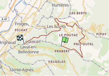
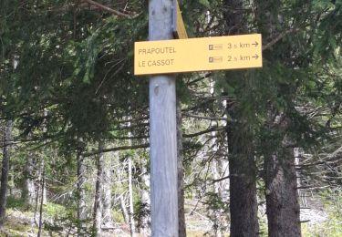
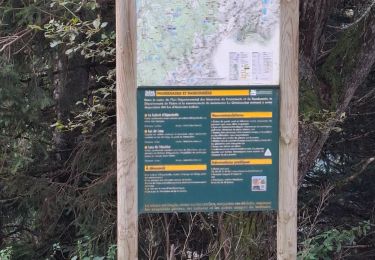
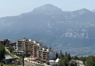
Ruta Senderismo de 14,8 km a descubrir en Auvergne-Rhône-Alpes, Isère, Laval-en-Belledonne. Esta ruta ha sido propuesta por jm.lemore.
Descripción
L'enregistrement n'a pas été mis en route au départ, mais il se fait à la Tour de Montfalet
Localización
País:
France
Región :
Auvergne-Rhône-Alpes
Departamento/provincia :
Isère
Municipio :
Laval-en-Belledonne
Localidad:
Unknown
Salida:(Dec)
Salida:(UTM)
733024 ; 5015563 (31T) N.
Comentarios
Excursiones cerca
![Excursión Senderismo Les Adrets - les 7 laux - Photo](https://media.geolcdn.com/t/375/260/ext.jpg?maxdim=2&url=https%3A%2F%2Fservices.sitytrail.com%2FGeolivesWS%2FDownloadMedia.ashx%3FTrailID%3D210621%26Media%3Dfix__20130806134428.jpg)
![Senderismo Senderismo](https://static1.geolcdn.com/sitytour/trail-icons/101.png)
les 7 laux
Senderismo
Medio
(1)
Les Adrets,
Auvergne-Rhône-Alpes,
Isère,
France
![](/images/other/stat-length.png)
12,4 km | 21 km-effort
4h 23min
![](https://static1.geolcdn.com/siteimages/upload/files/16400158638029165_repeat_loop_refresh_sync_direction_icon.png)
Sí
![Excursión Esquí de fondo Les Adrets - le jas de lièvre et vol de Bédina - Photo](https://media.geolcdn.com/t/375/260/fb6d4008-e294-44a8-86f0-b378b0a893a8.jpg&format=jpg&maxdim=2)
![Esquí de fondo Esquí de fondo](https://static1.geolcdn.com/sitytour/trail-icons/503.png)
le jas de lièvre et vol de Bédina
Esquí de fondo
Difícil
Les Adrets,
Auvergne-Rhône-Alpes,
Isère,
France
![](/images/other/stat-length.png)
12,6 km | 30 km-effort
7h 10min
![](https://static1.geolcdn.com/siteimages/upload/files/16400158638029165_repeat_loop_refresh_sync_direction_icon.png)
Sí
![Excursión Esquí de fondo Laval-en-Belledonne - col du Rafour et couloir ouest de la montagne de Barlet - Photo](https://media.geolcdn.com/t/375/260/93573ad3-540b-4442-acb2-432d15b1a0ec.jpg&format=jpg&maxdim=2)
![Esquí de fondo Esquí de fondo](https://static1.geolcdn.com/sitytour/trail-icons/503.png)
col du Rafour et couloir ouest de la montagne de Barlet
Esquí de fondo
Difícil
Laval-en-Belledonne,
Auvergne-Rhône-Alpes,
Isère,
France
![](/images/other/stat-length.png)
10,9 km | 26 km-effort
6h 29min
![](https://static1.geolcdn.com/siteimages/upload/files/16400158638029165_repeat_loop_refresh_sync_direction_icon.png)
No
![Excursión Esquí de fondo Laval-en-Belledonne - la dent du Pra par le col de l'Aigleton - Photo](https://media.geolcdn.com/t/375/260/35f172bb-b4cf-4c46-abfa-0c6386b3c585.jpg&format=jpg&maxdim=2)
![Esquí de fondo Esquí de fondo](https://static1.geolcdn.com/sitytour/trail-icons/503.png)
la dent du Pra par le col de l'Aigleton
Esquí de fondo
Difícil
Laval-en-Belledonne,
Auvergne-Rhône-Alpes,
Isère,
France
![](/images/other/stat-length.png)
12,7 km | 31 km-effort
7h 34min
![](https://static1.geolcdn.com/siteimages/upload/files/16400158638029165_repeat_loop_refresh_sync_direction_icon.png)
Sí
![Excursión Esquí de fondo Laval-en-Belledonne - couloir Est du sifflet et pas du pin par couloir ouest - Photo](https://media.geolcdn.com/t/375/260/923162f4-fc60-40a4-900d-69278daa194d.jpg&format=jpg&maxdim=2)
![Esquí de fondo Esquí de fondo](https://static1.geolcdn.com/sitytour/trail-icons/503.png)
couloir Est du sifflet et pas du pin par couloir ouest
Esquí de fondo
Difícil
Laval-en-Belledonne,
Auvergne-Rhône-Alpes,
Isère,
France
![](/images/other/stat-length.png)
13,2 km | 31 km-effort
8h 22min
![](https://static1.geolcdn.com/siteimages/upload/files/16400158638029165_repeat_loop_refresh_sync_direction_icon.png)
Sí
![Excursión Senderismo Theys - PROMENADE AUTOUR DU COL DES AYES - Photo](https://media.geolcdn.com/t/375/260/abb3a05c-1892-4f25-9e89-1857c335746d.jpg&format=jpg&maxdim=2)
![Senderismo Senderismo](https://static1.geolcdn.com/sitytour/trail-icons/101.png)
PROMENADE AUTOUR DU COL DES AYES
Senderismo
Medio
Theys,
Auvergne-Rhône-Alpes,
Isère,
France
![](/images/other/stat-length.png)
5,1 km | 8,1 km-effort
3h 31min
![](https://static1.geolcdn.com/siteimages/upload/files/16400158638029165_repeat_loop_refresh_sync_direction_icon.png)
Sí
![Excursión Senderismo Theys - BALADE DIGESTIVE APRES UNE FONDUE - Photo](https://media.geolcdn.com/t/375/260/be78689d-589e-4895-90df-62de51c805ee.jpg&format=jpg&maxdim=2)
![Senderismo Senderismo](https://static1.geolcdn.com/sitytour/trail-icons/101.png)
BALADE DIGESTIVE APRES UNE FONDUE
Senderismo
Medio
Theys,
Auvergne-Rhône-Alpes,
Isère,
France
![](/images/other/stat-length.png)
3,5 km | 6,1 km-effort
1h 5min
![](https://static1.geolcdn.com/siteimages/upload/files/16400158638029165_repeat_loop_refresh_sync_direction_icon.png)
Sí
![Excursión Senderismo Laval-en-Belledonne - PETITE RANDONNEE AU DEPART DU PONT DE LA BETTA - Photo](https://media.geolcdn.com/t/375/260/75136744-9eff-4307-a3ab-8becdc263614.jpg&format=jpg&maxdim=2)
![Senderismo Senderismo](https://static1.geolcdn.com/sitytour/trail-icons/101.png)
PETITE RANDONNEE AU DEPART DU PONT DE LA BETTA
Senderismo
Medio
Laval-en-Belledonne,
Auvergne-Rhône-Alpes,
Isère,
France
![](/images/other/stat-length.png)
6,1 km | 9,9 km-effort
1h 35min
![](https://static1.geolcdn.com/siteimages/upload/files/16400158638029165_repeat_loop_refresh_sync_direction_icon.png)
Sí
![Excursión sport Les Adrets - Les sept Laux - Photo](https://media.geolcdn.com/t/375/260/305680db-d5bf-44eb-bf28-b61ed10554dc.jpg&format=jpg&maxdim=2)
Les sept Laux
sport
Muy fácil
Les Adrets,
Auvergne-Rhône-Alpes,
Isère,
France
![](/images/other/stat-length.png)
4,1 km | 6,2 km-effort
Desconocido
![](https://static1.geolcdn.com/siteimages/upload/files/16400158638029165_repeat_loop_refresh_sync_direction_icon.png)
No