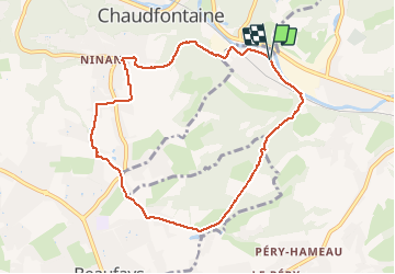
![](/images/other/stat-length.png)
![Excursión Senderismo Trooz - La Brouck Ninane Bois de la Walthine - Photo](https://media.geolcdn.com/t/1900/400/741fbe36-a351-48aa-84f1-5dbf765a3ac1.jpg&format=pjpeg&maxdim=2)
La Brouck Ninane Bois de la Walthine
amyrose
Usuario
![Longitud](/images/other/stat-length.png)
![Altitud máxima](https://static1.geolcdn.com/siteimages/upload/files/1508320355ic_sort_altitude_max_24dp.png)
![Desnivel positivo](https://static1.geolcdn.com/siteimages/upload/files/1508320355ic_sort_den_pos_24dp.png)
![Km-Effort](/images/other/stat-length.png)
![Altitud mínima](https://static1.geolcdn.com/siteimages/upload/files/1508320355ic_sort_altitude_min_24dp.png)
![Desnivel negativo](https://static1.geolcdn.com/siteimages/upload/files/1508320355ic_sort_den_neg_24dp.png)
![Boucle](https://static1.geolcdn.com/siteimages/upload/files/16400158638029165_repeat_loop_refresh_sync_direction_icon.png)
![Senderismo](https://static1.geolcdn.com/sitytour/trail-icons/101.png)
2h07
Dificultad : Medio
![Escanee este código QR para abrir la excursión en la aplicación SityTrail](https://capi.geolives.com/qq0zvz2zws4bq2lad0pu/sitytour/trails/2754084/qr.png?size=200)
Aplicación GPS de excursión GRATIS
A propósito
Ruta Senderismo de 8 km a descubrir en Valonia, Lieja, Trooz. Esta ruta ha sido propuesta por amyrose.
Descripción
départ La Brouck aller vers le bois de Dames tourner à gauche avant l'épuration longer le dressage pour chiens monter jusque la cahute d'information aller tout doit au pont continuer droit vers Ninâne dans le village tourner à gauche longer la grand route tourner à gauche (très pt chemin entre deux maisons balade jaune 3) chemin communal aller vers le panorama tourner à droite vers les maison ne pas rater le très
pt chemin à gauche lierre puis suivre Le balisage La Loignerie
Avant le rond point de Beaufays prendre le rue de la Walthine pour redescendre vers la brouck
Localización
Comentarios
Excursiones cerca
![Excursión Senderismo Chaudfontaine - RB-Lg-21_Chaudfontaine_via-racc-1-et-2 - Photo](https://media.geolcdn.com/t/375/260/ext.jpg?maxdim=2&url=https%3A%2F%2Fservices.sitytrail.com%2FGeolivesWS%2FDownloadMedia.ashx%3FTrailID%3D400756%26Media%3Db4e5d748-2e9a-46aa-887f-e41bafbe80d7.jpg)
![Senderismo Senderismo](https://static1.geolcdn.com/sitytour/trail-icons/101.png)
Senderismo
![](/images/other/stat-length.png)
![](https://static1.geolcdn.com/siteimages/upload/files/16400158638029165_repeat_loop_refresh_sync_direction_icon.png)
![Excursión Senderismo Chaudfontaine - RB-Lg-21_Chaudfontaine - Photo](https://media.geolcdn.com/t/375/260/ext.jpg?maxdim=2&url=https%3A%2F%2Fservices.sitytrail.com%2FGeolivesWS%2FDownloadMedia.ashx%3FTrailID%3D400753%26Media%3D0173f844-fd8a-4443-984d-43fa65695365.jpg)
![Senderismo Senderismo](https://static1.geolcdn.com/sitytour/trail-icons/101.png)
Senderismo
![](/images/other/stat-length.png)
![](https://static1.geolcdn.com/siteimages/upload/files/16400158638029165_repeat_loop_refresh_sync_direction_icon.png)
![Excursión Senderismo Chaudfontaine - Chaudfontaine, Natura 2000 - Des sites qui valent le détour, Lg7 - Photo](https://media.geolcdn.com/t/375/260/ext.jpg?maxdim=2&url=https%3A%2F%2Fservices.sitytrail.com%2FGeolivesWS%2FDownloadMedia.ashx%3FTrailID%3D188128%26Media%3Df5c5efa3-ad1d-47ec-bc6a-d75c5f96ada1.JPG)
![Senderismo Senderismo](https://static1.geolcdn.com/sitytour/trail-icons/101.png)
Senderismo
![](/images/other/stat-length.png)
![](https://static1.geolcdn.com/siteimages/upload/files/16400158638029165_repeat_loop_refresh_sync_direction_icon.png)
![Senderismo Senderismo](https://static1.geolcdn.com/sitytour/trail-icons/101.png)
Senderismo
![](/images/other/stat-length.png)
![](https://static1.geolcdn.com/siteimages/upload/files/16400158638029165_repeat_loop_refresh_sync_direction_icon.png)
![Senderismo Senderismo](https://static1.geolcdn.com/sitytour/trail-icons/101.png)
Senderismo
![](/images/other/stat-length.png)
![](https://static1.geolcdn.com/siteimages/upload/files/16400158638029165_repeat_loop_refresh_sync_direction_icon.png)
![Excursión Senderismo Trooz - 2021-05-16_08h02m48_1403 - Photo](https://media.geolcdn.com/t/375/260/d573d865-936c-49e5-ac73-8dda0a954532.jpg&format=jpg&maxdim=2)
![Senderismo Senderismo](https://static1.geolcdn.com/sitytour/trail-icons/101.png)
Senderismo
![](/images/other/stat-length.png)
![](https://static1.geolcdn.com/siteimages/upload/files/16400158638029165_repeat_loop_refresh_sync_direction_icon.png)
![Excursión Senderismo Olne - 2021-03-10_16h10m11_1409 - Photo](https://media.geolcdn.com/t/375/260/8c16a020-3972-4fd4-95a4-e68b814bf4ee.jpg&format=jpg&maxdim=2)
![Senderismo Senderismo](https://static1.geolcdn.com/sitytour/trail-icons/101.png)
Senderismo
![](/images/other/stat-length.png)
![](https://static1.geolcdn.com/siteimages/upload/files/16400158638029165_repeat_loop_refresh_sync_direction_icon.png)
![Excursión Senderismo Lieja - GG-Lg-10_Angleur - Nessonvaux - Photo](https://media.geolcdn.com/t/375/260/04d5e1fb-7fbe-4c80-8636-73a8d0ed7b0e.jpg&format=jpg&maxdim=2)
![Senderismo Senderismo](https://static1.geolcdn.com/sitytour/trail-icons/101.png)
Senderismo
![](/images/other/stat-length.png)
![](https://static1.geolcdn.com/siteimages/upload/files/16400158638029165_repeat_loop_refresh_sync_direction_icon.png)
![Excursión Senderismo Chaudfontaine - RB-Lg-21_Chaudfontaine_via-racc-1 - Photo](https://media.geolcdn.com/t/375/260/ext.jpg?maxdim=2&url=https%3A%2F%2Fservices.sitytrail.com%2FGeolivesWS%2FDownloadMedia.ashx%3FTrailID%3D400755%26Media%3Db4e5d748-2e9a-46aa-887f-e41bafbe80d7.jpg)
![Senderismo Senderismo](https://static1.geolcdn.com/sitytour/trail-icons/101.png)
Senderismo
![](/images/other/stat-length.png)
![](https://static1.geolcdn.com/siteimages/upload/files/16400158638029165_repeat_loop_refresh_sync_direction_icon.png)